- Shire of Yarra Ranges
-
Yarra Ranges Shire 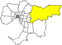
Lage des Yarra Ranges Shire in Melbourne Basisdaten Bundesstaat: Victoria Hauptort: Lilydale Fläche: 2.460 km² Einwohner: 142.701 (Juni 2006) Wards: 9 Stadtteile: 51 Yarra Ranges Shire ist ein lokales Verwaltungsgebiet (LGA) im australischen Bundesstaat Victoria. Yarra Ranges gehört zur Outer Metropolitan Area von Melbourne, dem äußeren Großstadtgebiet der Hauptstadt Victorias. Das Gebiet ist mit 2.460 km² die flächenmäßig größte LGA der Stadt und hat etwa 143.000 Einwohner.
Yarra Ranges liegt 34 bis 80 km entfernt vom Stadtzentrum am nordöstlichen Ende Melbournes und enthält 51 Stadtteile und Ortschaften: Badger Creek, Belgrave, Belgrave Heights, Belgrave South, Chirnside Park, Chum Creek, Coldstream, Dixons Creek, Don Valley, Ferntree Gully Upper, Ferny Creek, Gruyere, Healesville, Kallista, Kalorama, Kilsyth, Launching Place, Lilydale, Macclesfield, Menzies Creek, Millgrove, Monbulk, Montrose, Mooroolbark, Mount Dandenong, Mount Evelyn, Narre Warren East, Olinda, Sassafras, Selby, Seville, Seville East, Sherbrooke, Silvan, Steels Creek, Tarrawarra, Tecoma, The Patch, Tremont, Upwey, Wandin East, Wandin North, Warburton, Warburton East, Wesburn, Woori Yallock, Yarra Glen, Yarra Junction, Yellingbo und Yering. Der Sitz des City Councils befindet sich in Lilydale.
Das Shire liegt in hügeligem bis bergigem Gelände. Etwa in der Mitte befindet sich der Mount Donna Buang. Auf dem Gipfel mit einer Höhe von 1250 m liegt im Winter gewöhnlich Schnee und es ist damit das dem Stadtzentrum Melbournes am nächsten gelegene Schneegebiet. In den Yarra Ranges wurden aufgrund der geologischen Gegebenheiten eine ganze Reihe von Stauseen angelegt, die größten sind das Upper Yarra Reservoir, das Silvan und das Maroondah Reservoir. Das Gebiet leistet somit einen wichtigen Beitrag zur Wasserversorgung der Metropole Melbourne.
Der 633 m hohe Mount Dandenong inmitten der Dandenong Ranges ist der Standort der Rundfunksendemasten für Melbourne, die nochmals zwischen 72 m und 180 m hoch sind. Entsprechend reicht die Sicht bei gutem Wetter vom Gipfel des Berges bis ins Stadtzentrum oder die Port Phillip Bay.
Yering war eine der frühen Hochburgen australischen Weinbaus und bekam bereits Ende des 19. Jahrhunderts internationale Anerkennung. Nach einer zwischenzeitlichen Flaute ist das Yarra Valley heute wieder eine beliebte Weinregion. Daneben wird auf den landwirtschaftlichen Nutzflächen des Shires viel Obst angebaut.
Belgrave im Südwesten des Shires ist der Ausgangspunkt von Puffing Billy, der einzigen erhaltenen historischen Dampfeisenbahn Melbournes. Die Strecke der Touristenbahn führt Richtung Südwesten zum Emerald Lake und durch den Norden des Cardinia Shire bis nach Gembrook.
Verwaltung
Der Yarra Ranges Shire Council hat neun Mitglieder, die von den Bewohnern der neun Wards gewählt werden. Diese neun Wahlbezirke (Billanook, Chandler, Chrinside, Lyster, Melba, O'Shannassy, Ryrie, Streeton und Walling) sind unabhängig von den Stadtteilen festgelegt. Aus dem Kreis der Councillor rekrutiert sich auch der Mayor (Bürgermeister) des Councils.
Weblinks
Ländliche Gebiete: Alpine | Ararat | Ballarat | Bass Coast | Baw Baw | Benalla | Buloke | Campaspe | Central Goldfields | Colac Otway | Corangamite | East Gippsland | Gannawarra | Glenelg | Golden Plains | Greater Bendigo | Greater Geelong | Greater Shepparton | Hepburn | Hindmarsh | Horsham | Indigo | Latrobe | Loddon | Macedon Ranges | Mansfield | Mildura | Mitchell | Moira | Moorabool | Mount Alexander | Moyne | Murrindindi | Northern Grampians | Pyrenees | Queenscliffe | South Gippsland | Southern Grampians | Strathbogie | Surf Coast | Swan Hill | Towong | Wangaratta | Warrnambool | Wellington | West Wimmera | Wodonga | Yarriambiack
Greater Melbourne: Banyule | Bayside | Boroondara | Brimbank | Cardinia | Casey | Darebin | Frankston | Glen Eira | Greater Dandenong | Hobsons Bay | Hume | Kingston | Knox | Manningham | Maroondah | Maribyrnong | Melbourne | Melton | Monash | Moonee Valley | Moreland | Mornington Peninsula | Nillumbik | Port Phillip | Stonnington | Whitehorse | Whittlesea | Wyndham | Yarra | Yarra Ranges

Wikimedia Foundation.