- Boroondara City
-
City of Boroondara 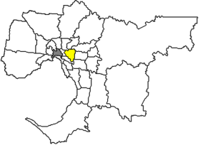
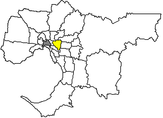
Lage von Boroondara City in MelbourneGliederung Staat:  Australien
Bundesstaat:  Victoria
Verwaltungssitz: Camberwell Daten und Zahlen Fläche: 60 km² Einwohner: 154.450 (2006) [1] Bevölkerungsdichte: 2.574 Einwohner je km² Postleitzahl: 3101-3147 Wards: 10 -37.833333333333145.06666666667Koordinaten: 37° 50′ S, 145° 4′ OBoroondara City ist ein lokales Verwaltungsgebiet (LGA) im australischen Bundesstaat Victoria. Boroondara gehört zur Metropole Melbourne, der Hauptstadt Victorias. Das Gebiet ist 60 km² groß und hat etwa 160.000 Einwohner.
Boroondara liegt 5 bis 14 km östlich des Stadtzentrums von Melbourne und enthält 12 Stadtteile: Ashburton, Balwyn, Balwyn North, Camberwell, Canterbury, Hawthorn, Hawthorn East, Kew, Kew East und Teile von Glen Iris, Mont Albert und Surrey Hills. Die Westgrenze der City bildet der Yarra River. Der Sitz des City Councils befindet sich in Camberwell.
Der Name Boroondara bedeutet "schattig dichtes Land" in der Sprache der lokalen Ureinwohner und deutet auf die waldreiche Vergangenheit des Gebietes hin. 1837 siedelten dort die ersten Europäer. Heute hat die City neben Parkanlagen große Wohngebiete und einige der teuersten und exklusivsten Wohngegenden Melbournes z. B. in den Stadtteilen Canterbury und Kew.
Boroondara ist ein Zentrum für Bildung in Melbourne. Es hat die größte Dichte an Privatschulen weltweit. Außerdem gibt es fünf Bibliotheken in Boroondara.
Der australische Komiker und Dame-Edna-Darsteller Barry Humphries ist im Stadtteil Camberwell geboren und aufgewachsen.
Verwaltung
Der Boroondara City Council hat zehn Mitglieder, die von den Bewohnern der zehn Wards gewählt werden. Diese zehn Bezirke (Bellevue, Maranoa, Maling, Lynden, Solway, Gardiner, Studley, Cotham, Junction und Glenferrie) sind unabhängig von den Stadtteilen festgelegt. Aus dem Kreis der Councillor rekrutiert sich auch der Mayor (Bürgermeister) des Councils.
Weblinks
- Offizielle Seite (englisch)
Einzelnachweise
- ↑ Australian Bureau of Statistics (25. Oktober 2007): Boroondara (C) (Local Government Area) (Englisch). 2006 Census QuickStats. Abgerufen am 6. April 2010.
Ländliche Gebiete: Alpine | Ararat | Ballarat | Bass Coast | Baw Baw | Benalla | Buloke | Campaspe | Central Goldfields | Colac Otway | Corangamite | East Gippsland | Gannawarra | Glenelg | Golden Plains | Greater Bendigo | Greater Geelong | Greater Shepparton | Hepburn | Hindmarsh | Horsham | Indigo | Latrobe | Loddon | Macedon Ranges | Mansfield | Mildura | Mitchell | Moira | Moorabool | Mount Alexander | Moyne | Murrindindi | Northern Grampians | Pyrenees | Queenscliffe | South Gippsland | Southern Grampians | Strathbogie | Surf Coast | Swan Hill | Towong | Wangaratta | Warrnambool | Wellington | West Wimmera | Wodonga | Yarriambiack
Greater Melbourne: Banyule | Bayside | Boroondara | Brimbank | Cardinia | Casey | Darebin | Frankston | Glen Eira | Greater Dandenong | Hobsons Bay | Hume | Kingston | Knox | Manningham | Maroondah | Maribyrnong | Melbourne | Melton | Monash | Moonee Valley | Moreland | Mornington Peninsula | Nillumbik | Port Phillip | Stonnington | Whitehorse | Whittlesea | Wyndham | Yarra | Yarra Ranges
Wikimedia Foundation.
Schlagen Sie auch in anderen Wörterbüchern nach:
City of Boroondara — Victoria City of Harmony Population: 168,090(2009)[1] … Wikipedia
City of Boroondara — Lage von Boroondara City in Melbourne Basisdaten Bundesstaat: Victoria Hauptort: Camberwell Fläche … Deutsch Wikipedia
City of Whitehorse — Victoria Map of Melbourne showing City of Whitehorse Population: 155,725(2009) … Wikipedia
City of Banyule — Lage der Banyule City in Melbourne Basisdaten Bundesstaat: Victoria Hauptort: Ivanhoe Fläche: 63 … Deutsch Wikipedia
City of Bayside — Lage von Bayside City in Melbourne Basisdaten Bundesstaat: Victoria Hauptort: Sandringham Fläche: 37 … Deutsch Wikipedia
City of Brimbank — Lage von Brimbank City in Melbourne Basisdaten Bundesstaat: Victoria Hauptort: Sunshine Fläche: 123 … Deutsch Wikipedia
City of Casey — Lage von Casey City in Melbourne Basisdaten Bundesstaat: Victoria Hauptort: Narre Warren Fläche: 395 … Deutsch Wikipedia
City of Darebin — Lage von Darebin City in Melbourne Basisdaten Bundesstaat: Victoria Hauptort: Preston Fläche … Deutsch Wikipedia
City of Frankston — Lage von Frankston City in Melbourne Basisdaten Bundesstaat: Victoria Hauptort: Frankston Fläche: 131 … Deutsch Wikipedia
City of Glen Eira — Lage von Glen Eira City in Melbourne Basisdaten Bundesstaat: Victoria Hauptort: Caulfield Fläche: 37 … Deutsch Wikipedia
Boroondara City
18+
© Academic, 2000-2026
- Kontaktieren Sie uns: Unterstützung, Werbung
Wörterbücher Export, schritte mit PHP, Joomla, Drupal, WordPress, MODx.