- Balabac
-
Municipality of Balabac Lage von Balabac in der Provinz Palawan Basisdaten Bezirk: Western Visayas Provinz: Palawan Barangays: 20 Distrikt: 2. Distrikt von Palawan PSGC: 175304000 Einkommensklasse: unbekannt (1-6) Haushalte: 4723 Zensus 1. Mai 2000Einwohnerzahl: 29.622 Zensus 1. August 2007Koordinaten: 7° 59′ N, 117° 4′ O7.982117.06Koordinaten: 7° 59′ N, 117° 4′ O Postleitzahl: 5307 Geographische Lage auf den Philippinen Balabac ist eine philippinische Insel und Stadtgemeinde in der Provinz Palawan. Nach dem Zensus vom 1. Mai 2000 hat sie 25.257 Einwohner in 4723 Haushalten.
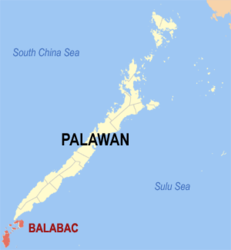
Die Insel mißt in Nord-Süd-Richtung ungefähr 30 km, in Ost-West 12 km.
Zur Gemeinde gehören neben der Hauptinsel weitere Inseln im Nordosten: Bancalan, Bugsuk, Pandanan und Mantangule, sowie im Norden, nur durch einen schmalen Meeresarm getrennt, Ramos, eine kreisförmige Insel von beinahe 6 km Durchmesser.
10 km im Osten liegt die kleine Insel Lumbucan, die eine dreieckige Form hat, wobei die längste Seite weniger als 2 km lang ist. Neben Lumbucan erstreckt sich der Lumbucan-Kanal.
Im Süden, jenseits der Balabacstraße, beginnt Malaysia.
Das seltene Palawan-Bartschwein lebt auf Balabac.
Verwaltungsgliederung
1957 wurde Balabac von einem Gemeindedistrikt zu einer Gemeinde angehoben [1].
Die Insel selbst ist in 20 Baranggays unterteilt.
- Agutayan
- Bugsuk (New Cagayancillo)
- Bancalaan
- Indalawan
- Catagupan
- Malaking Ilog
- Mangsee
- Melville
- Pandanan
- Pasig
- Rabor
- Ramos
- Salang
- Sebaring
- Poblacion I
- Poblacion II
- Poblacion III
- Poblacion IV
- Poblacion V
- Poblacion VI
Anmerkung: Población (spanisch für Population) bezeichnet auf den Philippinen mehrere im Zentrum einer Stadtgemeinde liegende Barangays.
Einzelnachweise
- ↑ R.A. No. 2022, An Act Converting the Municipal District of Balabac, Province of Palawan, into a Regular Municipality. LawPH.com. Abgerufen am 12. Juni 2011.
Städte und Stadtgemeinden in der Provinz PalawanStädte: Puerto Princesa City
Stadtgemeinden: Aborlan | Agutaya | Araceli | Balabac | Bataraza | Brooke's Point | Busuanga | Cagayancillo | Coron | Culion | Cuyo | Dumaran | El Nido | Kalayaan | Linapacan | Magsaysay | Narra | Quezon | Rizal | Roxas | San Vicente | Sofronio Española | Taytay
Wikimedia Foundation.
Schlagen Sie auch in anderen Wörterbüchern nach:
Balabac — ▪ island, Philippines island, extreme southwestern Philippines. It is located about 19 miles (30 km) southwest of the southern tip of Palawan island, and hardly twice that north of Borneo. Balabac rises to an elevation of about 1,890 feet… … Universalium
Balabac — Original name in latin Balabac Name in other language Balabac State code PH Continent/City Asia/Manila longitude 7.9868 latitude 117.0645 altitude 5 Population 9881 Date 2011 07 31 … Cities with a population over 1000 database
Balábac (Palawan) — Saltar a navegación, búsqueda Mapa que muestra la localización de Balábac. Balábac es una municipalidad de 3ra clase en la provincia de Palawan, en Filipinas. De acuerdo con el censo del 2000, tiene una población de 25,257 habitantes y 4,723… … Wikipedia Español
Balabac, Palawan — Balabac is a 3rd class municipality in the province of Palawan, Philippines. According to the 2000 census, it has a population of 25,257 people in 4,723 households.BarangaysBalabac is politically subdivided into 20 barangays.External links* [http … Wikipedia
Balabac Strait — is a strait in the South China Sea, at coord|7.6666667|N|117|E|. It separates the Balabac island (Palawan province), Philippines from the islands north of Borneo that are a part of Malaysia s Sabah state … Wikipedia
Balabac Island — is an island in the Philippines, at coord|7.95|N|117.0208333|E|. It is a part of the Palawan province.The island is home to various endemic species. It is the home of birds like Grey Imperial pigeon ( Ducula pickeringii ), Philippine Cockatoo… … Wikipedia
Isla de Balabac — Mapa de Palawan mostrando la ubicación de Balábac. La isla de Balabac es la isla más grande hacia el sur. La isla de Balabac es una isla ubicada en Filipinas, (coordenadas … Wikipedia Español
Détroit de Balabac — 7°40′00″N 117°00′00″E / 7.666667, 117 Le détroit de Balabac est un détroit reliant la mer de Sulu à la … Wikipédia en Français
Straße von Balabac — DMS … Deutsch Wikipedia
gobemouche de Balabac — palavaninė mėlynoji musinukė statusas T sritis zoologija | vardynas atitikmenys: lot. Cyornis lemprieri angl. Palawan blue flycatcher vok. Palawanblauschnäpper, m pranc. gobemouche de Balabac, m ryšiai: platesnis terminas – mėlynosios musinukės … Paukščių pavadinimų žodynas