- Tabontabon
-
Municipality of Tabontabon Lage von Tabontabon in der Provinz Leyte 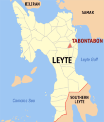
Basisdaten Bezirk: Eastern Visayas Provinz: Leyte Barangays: 16 Distrikt: 2. Distrikt von Leyte PSGC: 083746000 Einkommensklasse: 5. Einkommensklasse Haushalte: 1692 Zensus 1. Mai 2000Einwohnerzahl: 9.518 Zensus 1. August 2007Koordinaten: 11° 2′ N, 124° 58′ O11.041124.961Koordinaten: 11° 2′ N, 124° 58′ O Offizielle Webpräsenz: Tabontabon Geographische Lage auf den Philippinen 

Tabontabon Tabontabon ist eine philippinische Stadtgemeinde in der Provinz Leyte. Nach dem Zensus vom 1. Mai 2000 hat sie 8372 Einwohner in 1692 Haushalten.
Baranggays
Tabontabon ist politisch in 16 Baranggays unterteilt.
- Amandangay
- Aslum
- Balingasag
- Belisong
- Cambucao
- Capahuan
- Guingawan
- Jabong
- Mercadohay
- Mering
- Mohon
- District I Pob. (Quezon)
- District II Pob. (Rizal)
- District III Pob. (Bonifacio
- District IV Pob. (Macarthur)
- San Pablo (Mooc)
Städte und Stadtgemeinden in der Provinz LeyteStädte: Baybay City | Ormoc City | Tacloban City
Stadtgemeinden: Abuyog | Alangalang | Albuera | Babatngon | Barugo | Bato | Burauen | Calubian | Capoocan | Carigara | Dagami | Dulag | Hilongos | Hindang | Inopacan | Isabel | Jaro | Javier | Julita | Kananga | La Paz | Leyte | MacArthur | Mahaplag | Matag-ob | Matalom | Mayorga | Merida | Palo | Palompon | Pastrana | San Isidro | San Miguel | Santa Fe | Tabango | Tabontabon | Tanauan | Tolosa | Tunga | Villaba
Wikimedia Foundation.
Schlagen Sie auch in anderen Wörterbüchern nach:
Tabontabon — Original name in latin Tabontabon Name in other language Tabontabon State code PH Continent/City Asia/Manila longitude 11.04083 latitude 124.96111 altitude 20 Population 2557 Date 2011 07 31 … Cities with a population over 1000 database
Tabontabon, Leyte — Tabontabon is a 5th class municipality in the province of Leyte, Philippines. According to the 2000 census, it has a population of 8,372 people in 1,692 households.BarangaysTabontabon is politically subdivided into 16 barangays.External links*… … Wikipedia
Dagami, Leyte — Municipality Seal … Wikipedia
Legislative districts of Leyte — Philippines This article is part of the series: Politics and government of the Philippines … Wikipedia
Dulag, Leyte — Dulag is a third class municipality in the province of Leyte in Eastern Visayas (Region VIII) in the Philippines. This coastal town covering 11,007 hectares of land is home to 44,143 residents. It lies 36 kilometers south of the concurrent… … Wikipedia
PH-LEY — Lage der Provinz Leyte Die Provinz Leyte ist eine Provinz des Inselstaates der Philippinen. Sie erstreckt sich über den nördlichen Teil der Insel Leyte und ist eine von sechs Provinzen, die politisch dem Regierungsbezirk Eastern Visayas (Region… … Deutsch Wikipedia
Battle of Leyte — Infobox Military Conflict conflict=Battle of Leyte caption=Gen. Douglas MacArthur and staff land at Palo Beach, Leyte, 20 October 1944. partof=the Pacific Theatre of World War II date=20 October – 31 December 1944 place=Leyte Island, Philippines… … Wikipedia
Provinces of the Philippines — The provinces of the Philippines are the primary administrative divisions of the Philippines. There are 81 provinces, further subdivided into cities and municipalities. The National Capital Region is autonomous of provincial government. Each… … Wikipedia
Leyte — Infobox Philippine province name = Leyte sealfile = Ph seal leyte.png region = Eastern Visayas (Region VIII) capital = Tacloban City founded = 1543 and March 10, 1917 pop2000 = 1,592,336 pop2000rank = 14th largest popden2000 = 279 popden2000rank … Wikipedia
96th Sustainment Brigade (United States) — Infobox Military Unit unit name= 96th Infantry Division caption=96th Sustainment Brigade shoulder sleeve insignia dates= 1942 1946 country= United States allegiance= branch= U.S. Army type= role= size= command structure= garrison= garrison label … Wikipedia
Tabontabon


18+
© Academic, 2000-2026
- Kontaktieren Sie uns: Unterstützung, Werbung
Wörterbücher Export, schritte mit PHP, Joomla, Drupal, WordPress, MODx.