- Leyte (Leyte)
-
Municipality of Leyte Lage von Leyte in der Provinz Leyte Basisdaten Bezirk: Eastern Visayas Provinz: Leyte Barangays: 30 Distrikt: 3. Distrikt von Leyte PSGC: 083729000 Einkommensklasse: 4. Einkommensklasse Haushalte: 6889 Zensus 1. Mai 2000Einwohnerzahl: 35.478 Zensus 1. August 2007Koordinaten: 11° 22′ N, 124° 29′ O11.366666666667124.48333333333Koordinaten: 11° 22′ N, 124° 29′ O Postleitzahl: 6533 Bürgermeister: Armando Mendiola Ysidro Geographische Lage auf den Philippinen Leyte ist eine philippinische Stadtgemeinde in der Provinz Leyte. Nach dem Zensus vom 1. Mai 2000 hat sie 35.241 Einwohner in 6889 Haushalten.
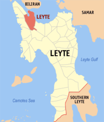
Baranggays
Leyte ist politisch in 30 Baranggays unterteilt.
- Bachao
- Baco
- Bagaba-o
- Basud
- Belen
- Burabod
- Calaguise
- Consuegra
- Culasi
- Danus
- Elizabeth
- Kawayan
- Libas
- Maanda
- Macupa
- Mataloto
- Palarao
- Palid I (Ilawod)
- Palid II (Iraya)
- Parasan
- Poblacion
- Salog
- Sambulawan
- Tag-abaca
- Tapol
- Tigbawan
- Tinocdugan
- Toctoc
- Ugbon
- Wague
Städte und Stadtgemeinden in der Provinz LeyteStädte: Baybay City | Ormoc City | Tacloban City
Stadtgemeinden: Abuyog | Alangalang | Albuera | Babatngon | Barugo | Bato | Burauen | Calubian | Capoocan | Carigara | Dagami | Dulag | Hilongos | Hindang | Inopacan | Isabel | Jaro | Javier | Julita | Kananga | La Paz | Leyte | MacArthur | Mahaplag | Matag-ob | Matalom | Mayorga | Merida | Palo | Palompon | Pastrana | San Isidro | San Miguel | Santa Fe | Tabango | Tabontabon | Tanauan | Tolosa | Tunga | Villaba
Wikimedia Foundation.
Schlagen Sie auch in anderen Wörterbüchern nach:
Leyte (disambiguation) — Leyte may refer to: In the Philippines *Leyte (island), the fourth largest island in the Visayas group of the Philippines. *Leyte Gulf, the body of water immediately east of the island of Leyte. *Leyte, a province of the Philippines that occupies … Wikipedia
Leyte (Begriffsklärung) — Leyte steht für: Leyte, eine Insel der Philippinen den Golf von Leyte, ein Meeresbecken, das östlich der gleichnamigen Insel liegt Leyte (Provinz), eine Provinz der Philippinen, die drei viertel der Insel Leyte einnimmt Leyte (Leyte), eine… … Deutsch Wikipedia
LEYTE — Île de l’archipel des Visayas (Philippines), dans la région de Visayas Est, située au nord de l’île de Mindanao, Leyte est par sa superficie (7 215 km2) la huitième île des Philippines. Ses côtes sont indentées de profondes baies au nord, à… … Encyclopédie Universelle
Leyte del Sur — Provincia de Filipinas … Wikipedia Español
Leyte — prop. n. The name of an island in the Pacific Ocean and of a battle in World War II, at which the American forces experienced the first use of Kamikaze aircraft by the Japanese. The return of U. S. troops to the Philippines after their expulsion… … The Collaborative International Dictionary of English
Leyte Gulf — is the body of water immediately east of the island of Leyte in the Philippines, adjoining the Philippine Sea of the Pacific Ocean, at coord|10|50|N|125|25|E| display=title,inline.The gulf is bounded on the north by the island of Samar, which is… … Wikipedia
Leyte, Leyte — Leyte is a 5th class municipality in the province of Leyte, Philippines. According to the 2000 census, it has a population of 35,241 people in 6,889 households.BarangaysLeyte is politically subdivided into 30 barangays. * Bachao * Baco * Bagaba o … Wikipedia
Leyte — Leyte, batalla del golfo de ► Isla de Filipinas, en el grupo de las Visayas, entre las de Samar (NE), Cebú (O) y Bohol (SO); 7 213 km2 y 1 362 051 h. Forma las prov. de Leyte (con las islas de Biliran y Maripipi; 6 268 km2 y 1 302 648 h; cap.,… … Enciclopedia Universal
Leyte — [ lɛi̯tə], im östlichen Teil des Visayas Archipels, Philippinen, gelegene Insel, 7 214 km2, rd. 1,5 Mio. Einwohner. Ein zentrales bewaldetes Gebirge (bis 1 350 m über dem Meeresspiegel) durchzieht Leyte von Südsüdosten nach Nordnordwesten. Die… … Universal-Lexikon
Leyte — Leyte, Insel, aus der Gruppe der Bissayer (s.d. g) … Pierer's Universal-Lexikon
Leyte — Leyte, Insel der Visayasgruppe der Philippinen, unter 11° nördl. Br., von Mindanao durch die Surigaostraße getrennt, hat mit den Nebeninseln 7923 (nach andrer Messung 9976) qkm mit (1899) 270,491 Einw. (malaiische Visayas, im Innern Negrito). Die … Meyers Großes Konversations-Lexikon