Traeth Mawr

Traeth Mawr
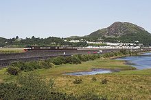
Ansicht des Dammes von der Landseite mit Porthmadog im Hintergrund.
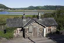
Das historische Mauthaus am südlichen Ende.

Der Traeth Mawr (walisisch "Großer Strand") ist ein Polder bei Porthmadog im Nordwesten von Wales. Das Gebiet östlich der Lleyn-Halbinsel war ursprünglich der Ästuar des Afon Glaslyn, der sich bis zur Pont Aberglaslyn etwa 12 Kilometer ins Hinterland erstreckt hat.


Im 18. Jahrhundert wurden dem Ästuar durch Deichbauten stückweise kleinere Landgebiete abgerungen. 1798 kaufte William Madocks (1773–1829) ein Stück Land und gründete darauf den Ort Tremadog [1] . Zwischen 1808 und 1811 ließ er einen Deich quer über die Flussmündung bauen und trennte damit den größten Teil des Ästauars vom Meer. Dieser Deich wird lokal „The Cob“ genannt und ist etwa 1,3 Kilometer lang. Über ihn führen die Küstenstraße A487 sowie die Strecke der Ffestiniog Railway. Die Mautpflicht für die Straßenbenützung wurde nach Verkauf der Straße an die walisische Nationalversammlung im Jahr 2003 aufgehoben. [2]

Am nordwestlichen Ende des Deichs entstand die Stadt Porthmadog; am südöstlichen Ende befindet sich der Steinbruch, in dem das notwendige Material gewonnen wurde. Hier ist auch das historische Mauthaus erhalten geblieben.

Außerhalb des Deichs vereinigt sich der Traeth Mawr mit dem Traeth Bach ("Kleiner Strand"), dem südöstlich gelegenen Ästuar des Afon Dwyryd. Das Poldergebiet wird landwirtschaftlich genutzt; außer den am Rand liegenden Orten Porthmadog und Tremadog gibt es, abgesehen von einzelnen Höfen, keine Ansiedlungen.

Treath Mawr war auch der Name einer provisorischen Endhaltestelle des von Porthmadog ausgehenden südlichen Teils der Welsh Highland Railway.

Einzelnachweise

  1. National Library of Wales – Portmadoc (Porthmadog) records
  2. BBC News: End of line for historic toll

Weblinks

 Commons: The Cob – Sammlung von Bildern, Videos und Audiodateien
 Commons: Virtuelle Reise auf der Ffestiniog Railway – Album mit Bildern und/oder Videos und Audiodateien

Wikimedia Foundation.

Игры ⚽ Поможем сделать НИР

Schlagen Sie auch in anderen Wörterbüchern nach:

  • Traeth Mawr — The Traeth Mawr (Welsh for big sands ) is a polder near Porthmadog in Gwynedd in Wales. It was formerly the tidal estuary of the river Glaslyn, and many travellers sank in its quicksands trying to cross it. Much of it is between high mountains.… …   Wikipedia

  • Traeth Mawr Loop — Infobox UK station name = Traeth Mawr Loop caption = manager = WHR Ltd locale = Porthmadog borough = Gwynedd latitude = 52.93998 longitude = 4.11254 lowusage0203 = lowusage0405 = lowusage0506 = platforms = 0 original = Croesor Tramway years = 23… …   Wikipedia

  • Welsh Highland Railway restoration — The restoration of Welsh Highland Railway has a colourful and complex history. This article provides the modern history: Welsh Highland Railway LimitedAfter the 1944 winding up of the old 1922 company, a few articles appeared in the railway press …   Wikipedia

  • Welsh Highland Railway (Porthmadog) — Heritage Railway name = Welsh Highland Railway (Rheilffordd Ucheldir Cymru) caption = Lyd2 No. 60 awaits work in Gelerts Farm Works yard locale = Wales terminus = Porthmadog and Traeth Mawr Loop| linename = Welsh Highland Railway Ltd builtby =… …   Wikipedia

  • Welsh Highland Railway — Heritage Railway name = Welsh Highland Railway (Rheilffordd Eryri / Rheilffordd Ucheldir Cymru) caption = Locomotive No. 138 Millennium/Mileniwm and train, leaving Caernarfon station locale = Wales terminus = Caernarfon and Porthmadog linename =… …   Wikipedia

  • Pen-y-Mount railway station — Infobox UK station name = Pen y Mount caption = manager = WHR Ltd locale = Porthmadog borough = Gwynedd latitude = 52.93415 longitude = 4.12392 lowusage0203 = 0.0 lowusage0405 = 0.0 lowusage0506 = 0.0 platforms = 1 years = 1980 events = Opened… …   Wikipedia

  • Pont Croesor railway station — Infobox UK station name = Pont Croesor other name = caption = Pont Croesor looking at the river Glaslyn from the bridge. manager = Ffestiniog Railway locale = Porthmadog borough = Gwynedd latitude = 52.95058 longitude = 4.09684 original = Croesor …   Wikipedia

  • Ffestiniog Railway — Heritage Railway name = Ffestiniog Railway caption = Two trains passing at Tan y Bwlch, c. 1900 locale = Wales terminus = Porthmadog linename = Festiniog Railway Company builtby = Festiniog Railway Company originalgauge = RailGauge|23.5… …   Wikipedia

  • Wick, Vale of Glamorgan — infobox UK place country = Wales welsh name= Y Wig constituency welsh assembly= latitude= 51.4376 longitude= 3.5508 map type= United Kingdom official name= Wick unitary wales= Vale of Glamorgan lieutenancy wales= South Glamorgan constituency… …   Wikipedia

  • Aberglaslyn Pass — The Aberglaslyn Pass ( cy. Bwlch Aberglaslyn) is a narrow gorge of considerable beauty in Snowdonia, Gwynedd, north Wales. The A498 road/A4085 road follows a relatively level route along the Afon Glaslyn through the pass from Beddgelert to… …   Wikipedia

Share the article and excerpts

Direct link
Do a right-click on the link above
and select “Copy Link”