- Tusayan
-
Tusayan 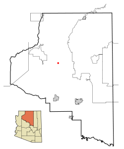 Lage im County und in Arizona
Basisdaten Staat: Vereinigte Staaten Bundesstaat: Arizona County: Koordinaten: 35° 59′ N, 112° 8′ W35.975277777778-112.128888888892015Koordinaten: 35° 59′ N, 112° 8′ W Zeitzone: Mountain Standard Time (UTC−7) Einwohner: 562 (Stand: 2000) Bevölkerungsdichte: 7,6 Einwohner je km² Fläche: 74,1 km² (ca. 29 mi²)
davon 74,0 km² (ca. 29 mi²) LandHöhe: 2015 m Postleitzahl: 86023 Vorwahl: +1 928 FIPS: 04-77490 GNIS-ID: 0042842 Tusayan ist eine Ortschaft mit 562 Einwohnern auf 74 km² im Coconino County im US-Bundesstaat Arizona. Bis 2010 war es ein sog Census-designated place. Das Dorf liegt an der Grenze zum Grand-Canyon-Nationalpark am U.S. Highway 180 sowie an der Arizona State Route 64. Nahe dem Dorf befindet sich auch der Grand Canyon National Park Airport.
 Orte im Coconino County
Bitter Springs | Cameron | Flagstaff | Fredonia | Grand Canyon Village | Kachina Village | Kaibito | Lechee | Leupp | Moenkopi | Mountainaire | Munds Park | Page | Parks | Sedona | Supai | Tonalea | Tuba City | Tusayan | Valle | Williams
Wikimedia Foundation.
Schlagen Sie auch in anderen Wörterbüchern nach:
Tusayan — Lugar designado por el censo de los Estados Unidos … Wikipedia Español
Tusayan — Tusayan, AZ U.S. Census Designated Place in Arizona Population (2000): 562 Housing Units (2000): 313 Land area (2000): 28.566507 sq. miles (73.986911 sq. km) Water area (2000): 0.012869 sq. miles (0.033331 sq. km) Total area (2000): 28.579376 sq … StarDict's U.S. Gazetteer Places
Tusayan, AZ — U.S. Census Designated Place in Arizona Population (2000): 562 Housing Units (2000): 313 Land area (2000): 28.566507 sq. miles (73.986911 sq. km) Water area (2000): 0.012869 sq. miles (0.033331 sq. km) Total area (2000): 28.579376 sq. miles… … StarDict's U.S. Gazetteer Places
Tusayan (Arizona) — Tusayan Lage im County und in Arizona Basisdaten Staat: V … Deutsch Wikipedia
Tusayan National Forest — was established by the U.S. Forest Service in Arizona on July 1, 1910 with 1,830,487 acres from part of Coconino National Forest and other lands. On October 22, 1934 the entire forest was transferred to Prescott National Forest and the name was… … Wikipedia
Tusayan, Arizona — Infobox Settlement official name = Tusayan, Arizona settlement type = CDP imagesize = image caption = image imagesize = image caption = image mapsize = 250px map caption = Location in Coconino County and the state of Arizona mapsize1 = map… … Wikipedia
Tusayan ruines — The Tusayan Ruines is a place near the Grand Canyon in Arizona where Chief Payan and his family lived. The ruines are on highway 64 in Arizona s Grand Canyon National Park … Wikipedia
National Register of Historic Places listings in Coconino County, Arizona — Location of Coconino County in Arizona This is a list of the National Register of Historic Places listings in Coconino County, Arizona. It is intended to be a complete list of the properties and districts on the National Register of Historic… … Wikipedia
Coconino County, Arizona — Coconino County, Arizona … Wikipedia
Glen Canyon — Glen Canyon, in southeastern and south central Utah and northwestern Arizona within the Vermilion Cliffs area, was carved by the Colorado River.A reservoir, Lake Powell, was created by the Glen Canyon Dam. Lake Powell emerged from a struggle over … Wikipedia
Tusayan


18+
© Academic, 2000-2024
- Kontaktieren Sie uns: Unterstützung, Werbung
Wörterbücher Export, schritte mit PHP, Joomla, Drupal, WordPress, MODx.