Ultisol

Ultisol
Ultisol

Als Ultisol bezeichnet man gemäß der USDA-Bodenklassifikation Waldböden der Tropen und Subtropen, die aufgrund intensiver Verwitterung und Auslaugung stark säurehaltig sind. Sie finden sich insbesondere in den südöstlichen Teilen der USA, in Mittelamerika, Brasilien und Argentinien, West- und Zentralafrika, Südostasien sowie Teilen Koreas, Japans und Nordostaustraliens und haben sich meist über einen verhältnismäßig langen Zeitraum hinweg ausgebildet.

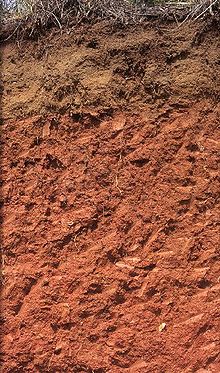
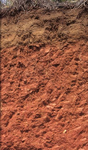
Typisch für Ultisole ist ein dünner gelblich gefärbter A-Horizont nahe der Oberfläche, unter dem sich ein tiefer, durch Eisenoxide rot gefärbter B-Horizont befindet.

Landwirtschaftlich sind Ultisole nur nach intensiver Düngung nutzbar, da die meisten Nährstoffe durch die Verwitterung in tiefere Bodenschichten verbracht wurden. Der niedrige pH-Wert muss zudem durch Kalkzusatz neutralisiert werden. Aus forstwirtschaftlicher Sicht werden Ultisole dagegen als sehr produktiv eingeschätzt.

Weltweit sind etwa 11 Millionen Quadratkilometer Land von Ultisolen bedeckt, dies entspricht 8,5 Prozent der eisfreien Landfläche.

Klassifikation

Man unterteilt Ultisole in fünf Unterordnungen:

  • Aquult
  • Humult
  • Udult
  • Ustult
  • Xerult

Weblinks


Wikimedia Foundation.

Игры ⚽ Поможем написать реферат

Schlagen Sie auch in anderen Wörterbüchern nach:

  • ultisol — /ul teuh sawl , sol /, n. a weathered, red and yellow acidic soil of warm, humid areas that is agriculturally productive when treated with lime and organic fertilizers. [1965 70; ULTI(MATE) + SOL] * * * ▪ soil type  one of the 12 soil orders in… …   Universalium

  • ultisol — noun A moist soil that has clay horizons and little lime …   Wiktionary

  • ultisol — /ul teuh sawl , sol /, n. a weathered, red and yellow acidic soil of warm, humid areas that is agriculturally productive when treated with lime and organic fertilizers. [1965 70; ULTI(MATE) + SOL] …   Useful english dictionary

  • Tschadbecken — Staubsturm über dem Tschadbecken am 18. November 2004 Quelle: NASA Das Schari Logone Fl …   Deutsch Wikipedia

  • North America — North American. the northern continent of the Western Hemisphere, extending from Central America to the Arctic Ocean. Highest point, Mt. McKinley, 20,300 ft. (6187 m); lowest, Death Valley, 276 ft. (84 m) below sea level. 400,000,000 including… …   Universalium

  • Soil — For other uses, see Soil (disambiguation). A represents soil; B represents laterite, a regolith; C represents saprolite, a less weathered regolith; the bottommost layer represents bedrock …   Wikipedia

  • Columbia, South Carolina — For other uses, see Columbia (disambiguation). Columbia   State Capital   City of Columbia …   Wikipedia

  • Swamp Laurel Oak — Taxobox color = lightgreen name = Swamp Laurel Oak status = secure regnum = Plantae divisio = Magnoliophyta classis = Magnoliopsida ordo = Fagales familia = Fagaceae genus = Quercus sectio = Lobatae species = Q. laurifolia binomial = Quercus… …   Wikipedia

  • Ultisols — are an order in USDA soil taxonomy. They are defined as mineral soils which contain no calcareous material anywhere within the soil , have less than 10% weatherable minerals in the extreme top layer of soil, and have less the 35% base saturation… …   Wikipedia

  • Sharavathi River — Geobox River name = Sharavathi native name = ಶರಾವತಿ other name = other name1 = image size = 300 image caption = Jog Falls formed by the Sharavathi river. country = India state = Karnataka city = Hosanagara city1 = Honnavar length = 128 watershed …   Wikipedia

Share the article and excerpts

Direct link
Do a right-click on the link above
and select “Copy Link”