- Vhembe
-
Vhembe
Vhembe District Municipality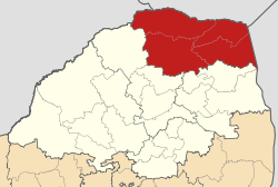
Symbole Wappen
Basisdaten Staat Südafrika Provinz Limpopo Sitz Thohoyandou Fläche 21.407,1 km² Einwohner 1.240.039 (24. Oktober 2007) Dichte 57,9 Einwohner pro km² Schlüssel DC34 ISO 3166-2 ZA-LP Webauftritt www.vhembe.gov.za (englisch) Politik Bürgermeister Rumane Florence Dzhombere -22.93333333333330.466666666667Koordinaten: 22° 56′ S, 30° 28′ OVhembe ist ein Distrikt innerhalb der Provinz Limpopo in Südafrika. Er hat 1.240.039 Einwohner (Stand: 24. Oktober 2007)[1] auf einer Gesamtfläche von 21.407 km². Sitz der Distriktverwaltung ist Thohoyandou. [2]
Der Distriktname ist die Bezeichnung für den Fluss Limpopo in den Sprachen Xitsonga und Tshivenda. [3]
Inhaltsverzeichnis
Gemeinden (Local Municipalities) mit ihren größten Städten
Demographische Daten
Datenstand 2001, Volkszählung. [4]
Sprache Einwohner % Tshivenda 818.894 68,35% Xitsonga 314.890 26,28% Sepedi 27.914 2,33% Afrikaans 13.696 1,14% Sesotho 7.706 0,64% Other 5.941 0,50% Englisch 4.545 0,38% IsiNdebele 1.759 0,15% IsiZulu 870 0,07% Setswana 832 0,07% IsiXhosa 655 0,05% SiSwati 329 0,03% Nationalparks und Naturschutzgebiete
Einzelnachweise
- ↑ Community Survey 2007. Basic Results. Statistics South Africa, 24. Oktober 2007, abgerufen am 29. Juni 2010 (englisch)..
Hinweise zu den Daten (englisch). - ↑ Verwaltungsgrenzen Südafrika
- ↑ Namensbedeutung Gemeinden
- ↑ Gemeindestatistik Südafrika
Distrikte der Provinz LimpopoCapricorn | Greater Sekhukhune | Mopani | Vhembe | Waterberg
Wikimedia Foundation.
Schlagen Sie auch in anderen Wörterbüchern nach:
Vhembe District Municipality — Vhembe is one of the 6 districts of Limpopo province of South Africa. It is the northernmost district of the country. The seat of Vhembe is Thohoyandou. The majority of its 1 199 856 people speak Venda (2001 Census). The district code is… … Wikipedia
Vhembe District Municipality — Admin ASC 2 Code Orig. name Vhembe District Municipality Country and Admin Code ZA.09.DC34 ZA … World countries Adminstrative division ASC I-II
Liste der Gemeinden Südafrikas — Dies ist eine Liste der südafrikanischen Gemeinden. Inhaltsverzeichnis 1 Metropolgemeinden 2 Freistaat 2.1 Xhariep – Xhariep District Municipality (DC16) 2.2 … Deutsch Wikipedia
Makhado Local Municipality — Local municipality Location in Limpopo … Wikipedia
Musina Local Municipality — Local municipality Location in Limpopo … Wikipedia
Mutale Local Municipality — Local municipality Location in Limpopo … Wikipedia
Liste der Gemeinden in der Provinz Limpopo — Limpopo mit eingezeichneten Distrikten und Gemeinden Die Liste der Gemeinden in der Provinz Limpopo führt alle Gemeinden (Local Municipalities) in der südafrikanischen Provinz Limpopo auf. Limpopo ist in 5 Distrikte (District Municipalities) mit… … Deutsch Wikipedia
Limpopo — This article is about the province in South Africa. For other uses, see Limpopo (disambiguation). Northern Transvaal redirects here. For the rugby union team, see Blue Bulls. Limpopo Province of South Africa The Province… … Wikipedia
Distrikte Südafrikas — (nummeriert) Südafrika ist in 52 Distrikte aufgeteilt. Es gibt 6 Metropolitan (gekennzeichnet mit *) und 46 District Municipalitys). Inhaltsverzeichnis 1 Westkap 2 Ostkap … Deutsch Wikipedia
Makhado — Local Municipality Symbole … Deutsch Wikipedia
- ↑ Community Survey 2007. Basic Results. Statistics South Africa, 24. Oktober 2007, abgerufen am 29. Juni 2010 (englisch)..
Vhembe

18+
© Academic, 2000-2026
- Kontaktieren Sie uns: Unterstützung, Werbung
Wörterbücher Export, schritte mit PHP, Joomla, Drupal, WordPress, MODx.