- Greater Sekhukhune
-
Greater Sekhukhune
Greater Sekhukhune District Municipality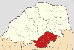
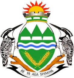
Symbole Wappen
Wahlspruch
„Re Ya Aga Siyakha“Basisdaten Staat Südafrika Provinz Limpopo Sitz Groblersdal Fläche 13.381,6 km² Einwohner 1.090.424 (24. Oktober 2007) Dichte 81,5 Einwohner pro km² Schlüssel DC47 ISO 3166-2 ZA-LP Webauftritt www.sekhukhune.gov.za (englisch) Politik Bürgermeister Mogobo David Magabe Greater Sekhukhune ist ein Distrikt innerhalb der Provinz Limpopo in Südafrika.[1] Benannt ist der Distrikt nach dem Pedi-König Sekhukhune, der hier im 18. Jahrhundert regierte.[2]
Der Distrikt ist selbst nochmals unterteilt in fünf Gemeinden:
- Elias Motsoaledi
- Fetakgomo
- Ephraim Mogale
- Greater Tubatse
- Makhudutamaga
Demographische Daten
Datenstand 2001, Volkszählung. [3]
Sprache Einwohner % Sepedi 806.206 83,36% IsiNdebele 42.453 4,39% IsiZulu 26.757 2,77% SiSwati 22.023 2,28% Setswana 22.002 2,27% Xitsonga 19.372 2,00% Sesotho 12.813 1,32% Afrikaans 7.956 0,82% IsiXhosa 2.186 0,23% Englisch 2.163 0,22% Tshivenda 1.659 0,17% Andere 1.564 0,16% Altersstruktur der Distriktbevölkerung
Alter Anzahl Anteil 0-19 531.652 54,97% 20-39 234.038 24,20% 40-59 121.099 12,52% 60 > 80.355 8,31% Schlagen Sie auch in anderen Wörterbüchern nach:
Sekhukhune District Municipality — Greater Sekhukhune is one of the 6 districts of Limpopo province of South Africa. The seat of Sekhukhune is Groblersdal. The majority of its 967 126 people speak Northern Sotho (2001 Census). The district code is DC47 (old code: CBDC3).… … Wikipedia
Liste der Gemeinden in der Provinz Limpopo — Limpopo mit eingezeichneten Distrikten und Gemeinden Die Liste der Gemeinden in der Provinz Limpopo führt alle Gemeinden (Local Municipalities) in der südafrikanischen Provinz Limpopo auf. Limpopo ist in 5 Distrikte (District Municipalities) mit… … Deutsch Wikipedia
Liste der Gemeinden Südafrikas — Dies ist eine Liste der südafrikanischen Gemeinden. Inhaltsverzeichnis 1 Metropolgemeinden 2 Freistaat 2.1 Xhariep – Xhariep District Municipality (DC16) 2.2 … Deutsch Wikipedia
Fetakgomo — Local Municipality Symbole … Deutsch Wikipedia
Distrikte Südafrikas — (nummeriert) Südafrika ist in 52 Distrikte aufgeteilt. Es gibt 6 Metropolitan (gekennzeichnet mit *) und 46 District Municipalitys). Inhaltsverzeichnis 1 Westkap 2 Ostkap … Deutsch Wikipedia
Liste des municipalités d'Afrique du Sud — Afrique du Sud Cet article fait partie de la série sur la politique de l Afrique du Sud, sous série sur la politique … Wikipédia en Français
Elias Motsoaledi (Gemeinde) — Elias Motsoaledi Elias Motsoaledi Local Municipality Symbole … Deutsch Wikipedia
Groblersdal — is a farming town situated 32 km North of the 178 million m³ Loskop Dam in the Sekhukhune District of Limpopo.The town is South Africa s second largest irrigation settlement. The main crops in this man made floodplain are cotton, tobacco, citrus… … Wikipedia
Liste der Distrikte in Südafrika — Distrikte Südafrikas (nummeriert) Die Liste der Distrikte in Südafrika führt alle Distrikte (District Municipalities) in Südafrika auf. Legende Nr.: Nummer des Distrikts auf der oben angeführten Karte Distrikt: Name des Distrikts Voller Name:… … Deutsch Wikipedia
List of South African Municipalities — This is a list of South African Municipalities. Refer to the main page for an explanation of how these are classified, and their inter relationships.Metropolitan Municipalities*City of Cape Town Metropolitan Municipality (Cape Town) (CPT)… … Wikipedia
Greater Sekhukhune

18+
© Academic, 2000-2024
- Kontaktieren Sie uns: Unterstützung, Werbung
Wörterbücher Export, schritte mit PHP, Joomla, Drupal, WordPress, MODx.