Watford Island

Watford Island
Boaz Island
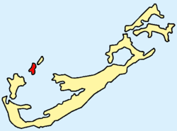
Lage der Insel innerhalb der Bermudas
Gewässer Atlantischer Ozean
Inselgruppe Bermuda
Geographische Lage 32° 18′ 32″ N, 64° 51′ 9″ W32.308888888889-64.85252Koordinaten: 32° 18′ 32″ N, 64° 51′ 9″ W
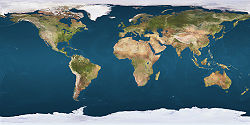
Boaz Island (Erde)
DEC
Boaz Island
Länge 900 m
Breite 200 m
Fläche 0,17 km²dep1
Höchste Erhebung 2 m
Einwohner dep1

Boaz Island ist eine flache Insel am Großen Sund im Nordwesten der atlantischen Inselgruppe Bermuda. Sie liegt südwestlich von Ireland Island (Südinsel) und nordöstlich von Somerset Island, mit denen sie jeweils über Brücken verbunden ist.

Das der Südküste unmittelbar vorgelagerte Eiland Watford Island (Geographische Lage: 32° 18′ 22″ N, 64° 51′ 23″ W32.306111111111-64.8563888888897) ist heute über einen befahrbaren Damm fest mit Boaz Island verbunden, und wird daher meist als deren Bestandteil angesehen.

Boaz Island war früher (ab 1933) ein Stützpunkt der britischen Seestreitkräfte (Royal Navy). Auf Watford Island findet sich aus dieser Zeit noch ein Friedhof für Militärpersonen.

Seit etlichen Jahren ist der militärische Stützpunkt aufgegeben; hier wohnen heute nur noch Zivilisten.

Boaz Island (nebst Watford Island) zählt zum Verwaltungsbezirk Sandys Parish.

Weblinks

Siehe auch


Wikimedia Foundation.

Игры ⚽ Нужна курсовая?

Schlagen Sie auch in anderen Wörterbüchern nach:

  • Watford Junction — Liste des stations du métro de Londres Article principal : Métro de Londres. Liste alphabétique des stations en service du Métro de Londres et du Docklands Light Railway (Underground et DLR). Seules les stations de correspondance du London… …   Wikipédia en Français

  • Boaz Island — Lage der Insel innerhalb der Bermudas Gewässer Atlantischer Ozean …   Deutsch Wikipedia

  • Islands of Bermuda — This is a list of the islands of Bermuda, listed alphabetically.*Agar s Island *Alpha Island *Banjo Island *Bartlett s Island *Bartram Island *Bay Island *Beta Island *Bethell s Island *Bird Island *Bluck s Island *Boaz Island *Brooks Island… …   Wikipedia

  • Liste der Inseln von Bermuda — Lage der 9 Parishes von Bermuda Bermuda ist eine aus etwa 150 Inseln bestehende Inselgruppe im Atlantischen Ozean und geopolitisch ein Britisches Überseegebiet. In dieser (unvollständigen) Liste werden einige der Bermuda Inseln aufgeführt. Die… …   Deutsch Wikipedia

  • Список островов Бермуд — Топографическая карта Бермудских островов Ниже приведен список островов Бермуд, отсортированный в алфавитном порядке …   Википедия

  • List of schools in the East of England — The following is a partial list of currently operating schools in the East region of England. You may also find of use to find a particular school. See also the List of the oldest schools in the United Kingdom.Listed by local education authority… …   Wikipedia

  • London Overground — Not to be confused with London Underground. London Overground …   Wikipedia

  • Heidar Helguson — Heiðar Helguson (* 22. August 1977 in Akureyri) ist ein isländischer Fußballspieler. Heiðar Helguson Spielerinformationen Geburtstag 22. August 1977 Geburtsort Akureyri, Island Position …   Deutsch Wikipedia

  • Helguson — Heiðar Helguson (* 22. August 1977 in Akureyri) ist ein isländischer Fußballspieler. Heiðar Helguson Spielerinformationen Geburtstag 22. August 1977 Geburtsort Akureyri, Island Position …   Deutsch Wikipedia

  • Martin Dugas — Personal information Date of birth 1 …   Wikipedia

Share the article and excerpts

Direct link
Do a right-click on the link above
and select “Copy Link”