Boaz Island

Boaz Island
Boaz Island
Lage der Insel innerhalb der Bermudas
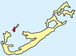
Gewässer Atlantischer Ozean
Inselgruppe Bermuda
Geographische Lage 32° 18′ 32″ N, 64° 51′ 9″ W32.308888888889-64.85252Koordinaten: 32° 18′ 32″ N, 64° 51′ 9″ W
Boaz Island (Bermuda)
Boaz Island
Länge 900 m
Breite 200 m
Fläche 0,17 km²dep1
Höchste Erhebung m

Boaz Island ist eine flache Insel am Großen Sund im Nordwesten der atlantischen Inselgruppe Bermuda. Sie liegt südwestlich von Ireland Island (Südinsel) und nordöstlich von Somerset Island, mit denen sie jeweils über Brücken verbunden ist.

Das der Südküste unmittelbar vorgelagerte Eiland Watford Island (Geographische Lage: 32° 18′ 22″ N, 64° 51′ 23″ W32.306111111111-64.856388888889) ist heute über einen befahrbaren Damm fest mit Boaz Island verbunden, und wird daher meist als deren Bestandteil angesehen.

Boaz Island war früher (ab 1933) ein Stützpunkt der britischen Seestreitkräfte (Royal Navy). Auf Watford Island findet sich aus dieser Zeit noch ein Friedhof für Militärpersonen.

Seit etlichen Jahren ist der militärische Stützpunkt aufgegeben; hier wohnen heute nur noch Zivilisten.

Boaz Island (nebst Watford Island) zählt zum Verwaltungsbezirk Sandys Parish.

Weblinks

Siehe auch


Wikimedia Foundation.

Игры ⚽ Нужно сделать НИР?

Schlagen Sie auch in anderen Wörterbüchern nach:

  • Boaz Island, Bermuda — Boaz Island, formerly known as Gate s Island or Yates Island , is one of the six main islands of Bermuda. It is part of a chain of islands in the west of the country that make up Sandys Parish, lying between the larger Ireland Island and Somerset …   Wikipedia

  • RNAS Boaz Island (HMS Malabar) — was a Royal Naval Air Station in Bermuda. The station became the primary base for the Royal Navy in the North West Atlantic following American independence. It was the location of a dockyard, an Admiralty House, and the base of a naval squadron.… …   Wikipedia

  • Watford Island — Boaz Island Lage der Insel innerhalb der Bermudas Gewässer Atlantischer Ozean Inselgruppe Bermuda …   Deutsch Wikipedia

  • Island of Vanar — The Land of Vanar = Vanar is a fictional land, the setting for the novel Vanity of Vanities by Martin Bertram. The Three Kingdoms of Vanar Kingdom of Rorq The greatest of the kingdoms of Vanar, Rorq was founded by Zacharias, the wealthy merchant… …   Wikipedia

  • Isla Boaz — Boaz Island Localización País  Reino Unido Archipiélago Berm …   Wikipedia Español

  • Darrell's Island — Darell’s Island Karte des Warwick Parish (Darell’s Island ist eingekreist) Gewässer Atlantischer Ozean …   Deutsch Wikipedia

  • Ordinance Island — Ordnance Island (Ordinance Island) Ordnance Island (Bildmitte) in der Bucht Bermuda Harbour Gewässer Atlantischer Ozean …   Deutsch Wikipedia

  • Saint David's Island (Bermuda) — Saint David’s Island Lage der Insel innerhalb der Bermudas Gewässer Atlantischer Ozean Inselgruppe Bermud …   Deutsch Wikipedia

  • Hinson's Island — Hinson’s Island Karte des Paget Parish (Hinson’s Island in der Bildmitte links) Gewässer Atlantischer Ozean Inselgr …   Deutsch Wikipedia

  • Ireland Island — North Lage der Inseln (Ireland Nord und Südinsel) innerhalb der Bermudas Gewässer Atlantischer Ozean …   Deutsch Wikipedia

Share the article and excerpts

Direct link
Do a right-click on the link above
and select “Copy Link”