- Åmot
-
Wappen Karte 
Basisdaten Kommunennummer: 0429 (auf Statistik Norwegen) Provinz (fylke): Hedmark Verwaltungssitz: Rena Koordinaten: 61° 8′ N, 11° 22′ O61.13166666666711.373055555556Koordinaten: 61° 8′ N, 11° 22′ O Fläche: 1.339 km² Einwohner: 4300 (1. Jan. 2011)[1]
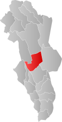
Bevölkerungsdichte: 3 Einwohner je km² Sprachform: neutral Webpräsenz: Politik Bürgermeister: Ole Gustav Narud (Sp) (2003) Lage in der Provinz Hedmark 
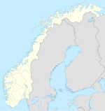
Åmot ist eine norwegische Kommune nordöstlich von Oslo in der Fylke Hedmark.
Geographie
Die Kommune ist 1.339 km² groß und hat 4300 Einwohner (1. Januar 2011). Im Norden grenzt Åmot an die Kommune Rendalen, im Osten an Trysil, im Süden an Elverum, im Südwesten an Løten, Hamar, Ringsaker und im Westen an Stor-Elvdal. Der Namen der Kommune leitet sich aus dem norwegischen å møte („treffen“) ab, da sich hier die Flüsse Glomma und Renaelva treffen.
Das Zentrum der Kommune ist der Ort Rena.
Einzelnachweise
- ↑ Statistics Norway – Berekna folkemengd 1. januar 2011 og berekna folketilvekst i 2010. Fylke og kommunar
Weblinks
 Commons: Åmot – Sammlung von Bildern, Videos und Audiodateien
Schlagen Sie auch in anderen Wörterbüchern nach:
Åmot — Blason de Åmot Localisation de Åmot dans le Hedmark … Wikipédia en Français
Åmot — Infobox Kommune name=Åmot idnumber=0429 county=Hedmark landscape=Østerdalen capital=Rena governor=Ole Gustav Narud (Sp) governor as of=2003 arearank=67 area=1340 arealand=1293 areapercent=0.41 population as of=2004 populationrank=217 population=4 … Wikipedia
Åmot IF — Football club infobox clubname = Åmot fullname = Åmot Idrettsforening nickname = founded = 10 March 1919 ground = Åmot stadion, Åmot, Norway capacity = | chairman = manager = Trygve Hagen league = Norwegian Fourth Division season = position =… … Wikipedia
AMOT — Angiomotin, also known as AMOT, is a human gene.cite web | title = Entrez Gene: AMOT angiomotin| url = http://www.ncbi.nlm.nih.gov/sites/entrez?Db=gene Cmd=ShowDetailView TermToSearch=154796| accessdate = ] PBB Summary section title = summary… … Wikipedia
Åmot — Sp Òmutas Ap Åmot L P Norvegija … Pasaulio vietovardžiai. Internetinė duomenų bazė
Amot — Admin ASC 2 Code Orig. name Åmot Country and Admin Code NO.06.0429 NO … World countries Adminstrative division ASC I-II
Åmot (disambiguation) — Åmot may refer to: *Åmot, a municipality in Hedmark, Norway *Åmot, Buskerud, a village in Modum Municipality, Buskerud, Norway *Åmot, Seljord, a village in Seljord Municipality, Telemark, Norway *Åmot, Skien, a village in Skien Municipality,… … Wikipedia
Åmot Lower Secondary School — ( no. Åmot Ungdomsskole) is a lower secondary school located in Åmot, Norway, with approximately 150 pupils and 20 employees.The school is nationally known in Norway for developing information and communication technology… … Wikipedia
Åmot, Vinje — Åmot is the administrative centre of Vinje municipality, Norway. Its population (SSB 2005) is 592.The European route E134 and the Tokke river pass through the village … Wikipedia
Åmot, Buskerud — Åmot is a village in Modum municipality, Norway. Located just south of Geithus, the two villages have grown closer to each other. They have a combined population of 5.694 [cite paper | author=Statistics Norway | title=Urban settlements.… … Wikipedia

