Boigu Island

Boigu Island
Boigu Island
Lage der Torres-Strait-Inseln:
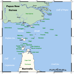
Boigu oben, Mitte.
Lage der Torres-Strait-Inseln:
Boigu oben, Mitte.
Gewässer Pazifischer Ozean
Inselgruppe Talbot-Inseln
Geographische Lage 9° 16′ S, 142° 13′ O-9.2623055555556142.2142972222218Koordinaten: 9° 16′ S, 142° 13′ O
Boigu Island (Papua-Neuguinea)
DEC
Boigu Island
Länge 18,12 km
Breite 5,05 km
Fläche 89,6 km²
Höchste Erhebung 18 m
Einwohner 270
Hauptort Boigu

Boigu, engl.: Boigu Island, ist die größte Insel der Talbot-Inseln, einer zum australischen Bundesstaat Queensland gehörigen Inselgruppe im Archipel der Torres-Strait-Inseln.

Verwaltungstechnisch zählt Boigu zu den Top Western Islands, einer Inselregion im Verwaltungsbezirk Torres Shire.

Die rund 90 km² große und flache Insel liegt 6 km vor der Südküste von Papua-Neuguinea in Höhe der Mündung des Mai Kussa. Sie gilt als die nördlichste bewohnte Insel von Australien.

Im Norden der Insel befindet sich die einzige (gleichnamige) Ansiedlung sowie eine für kleinere Flugzeuge geeignete Start- und Landebahn von etwa 800 Metern Länge.

Auf Boigu leben heute noch etwa 270 Menschen.

Siehe auch


Wikimedia Foundation.

Игры ⚽ Нужен реферат?

Schlagen Sie auch in anderen Wörterbüchern nach:

  • Boigu Island (Queensland) — Boigu Island (coord|9|16|S|142|13|E|region:AU QLD type:isle|display=inline,title) is the most northerly inhabited island in Australian territory. It is part of the top western group of the Torres Strait Islands, which lie in the Torres Strait… …   Wikipedia

  • Boigu Island Airport — airport codes|GIC|YBOI is an airport in Boigu Island, Queensland, Australia.Airlines and Destinations*Aero Tropics Air Services (Horn Island, Saibai Island) *Regional Pacific Airlines (Saibai Island) …   Wikipedia

  • Boigu — Island Landsat Bild von Boigu (Bildmitte), mit Moimi im Nordosten und Aubusi im Nordwesten …   Deutsch Wikipedia

  • Birds of Boigu, Saibai and Dauan Islands (Torres Strait) — The Birds of Boigu, Saibai and Dauan Islands (the Top Western group of Torres Strait), are of particular interest to Australian birders because the islands are home to, and visited by, birds which are essentially New Guinea species not found, or… …   Wikipedia

  • Île Boigu — 9° 16′ 00″ S 142° 13′ 00″ E / 9.266667, 142.216667 …   Wikipédia en Français

  • Horn Island Airport — Infobox Airport name = Horn Island Airprot IATA = HID ICAO = YHID location = Horn Island, Queensland elevation f = 43 elevation m = r1 number = 08/26 r1 length f = r1 length m = 1389 r1 surface = Asphalt r2 number = 14/32 r2 length m = 1235 r2… …   Wikipedia

  • Coconut Island Airport — (IATA: CNC[1], ICAO: YCCT[2]) is an airport located on Coconut Island (Poruma Island) in Queensland, Australia. Airlines and destinations Aero Tropics Air Services (Horn Island, Warraber Island, Yam Island, Yorke Island) Regional Pacific… …   Wikipedia

  • Darnley Island Airport — (IATA: NLF) is an airport in Darnley Island, Queensland, Australia. Airlines and destinations Aero Tropics Air Services (Horn Island, Murray Island, Yorke Island) Regional Pacific Airlines (Yorke Island) Coordinates …   Wikipedia

  • Murray Island Airport — IATA: MYI – ICAO: YMUI Summary Airport type Public Location Murray Island, Queensland, Australia …   Wikipedia

  • Mornington Island Airport — (IATA: ONG, ICAO: YMTI) is an airport on Mornington Island, Queensland, Australia. in 2006 the airport received $200,853 in funds to improve security.[1] Airlines and destinations Airlines Destinations Skytrans Airlines Burketown, Doomadgee …   Wikipedia

Share the article and excerpts

Direct link
Do a right-click on the link above
and select “Copy Link”