- Darnley Island
-
Darnley Island
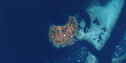
(Erub)Landsat-Bild der Insel Gewässer Pazifischer Ozean Geographische Lage 9° 35′ 41″ S, 143° 46′ 35″ O-9.5947777777778143.77639166667125Koordinaten: 9° 35′ 41″ S, 143° 46′ 35″ O Länge 3,25 km Breite 1,75 km Fläche 5,50 km² Höchste Erhebung 125 m Einwohner 320 (2006)
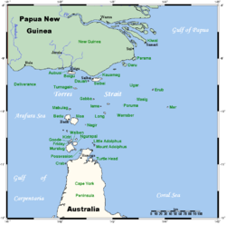
58 Einw./km²Lage der Torres-Strait-Inseln:
Darnley Island (Erub) Bildmitte, halbrechts.Darnley Island, von den Einheimischen Erub genannt, ist die nordöstlichste der bewohnten Torres-Strait-Inseln. Sie liegt etwa 200 km nordöstlich von Thursday Island, der "Hauptinsel" in der Torres Strait.
Die hügelige, flach bewachsene Insel ist vulkanischen Ursprungs, von unregelmäßiger Form und etwa 5,5 km² groß. Die höchste Erhebung von 125 Metern findet sich im Nordwesten. Einige kleinere Ansiedlungen liegen ebenfalls an der Nordwest- sowie der Südwestküste. Nach dem Zensus von 2006 lebten 320 Menschen auf der Insel, geringfügig mehr als 2001 (316).
Verwaltungstechnisch gehört Darnley zu den Eastern Islands, der östlichsten Inselregion im Verwaltungsbezirk Torres Shire von Queensland (Australien). Zur Region zählen auch die rund 45 km südöstlich gelegene Murray Island und das 25 km westlich gelegene Stephens Island.
Die Besitzer von Darnley Island sind die Meuran, einer der acht Stämme von Murray Island. Dieser Stamm ist auch im Besitz der Riffe und Sandbänke bis Bramble Cay im äußersten Nordosten der Torres-Strait-Inseln.[1]
Siehe auch
Einzelnachweise
Weblinks
zu Papua-Neuguinea gehörige Torres-Strait-Inseln: Bristow Island | Daru Island | Parama Island • Kawai-Inseln | Talbot-Inseln
Top Western: Boigu | Dauan | Deliverance | Saibai | Turnagain • Talbot-Inseln
Western: Badu | Mabuiag | Moa | Portlock | Tobin • Bellevue-Inseln | Duncan-Inseln | Farewell-Inseln | Kulbi-Inseln
Central: Aureed | Bourke | Coconut | Sassie | Sue | Yam | Yorke • Bourke-Inseln | Tetley-Inseln | The Three Sisters | Yorke-Inseln
Eastern: Bramble | Darnley | Murray | Stephens • Murray-Inseln
Inner: Albany | Booby | Crab | Entrance | Friday | Goods | Hammond | Horn | Packe | Port Lihou | Prince-of-Wales | Thursday | Wednesday • Manar-Inseln | Red-Wallis-Inseln | Thursday-Inseln | Tuesday-Inseln
Wikimedia Foundation.


