- Hammond Island
-
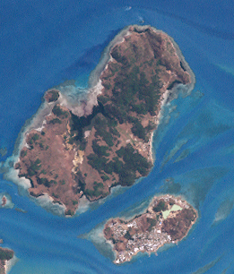
Hammond Island Landsat-Bild von Hammond Island (oben, Norden) und Thursday Island (unten)
Gewässer Pazifischer Ozean Inselgruppe Thursday-Inseln Geographische Lage 10° 33′ 17″ S, 142° 12′ 20″ O-10.554733333333142.2054333333370Koordinaten: 10° 33′ 17″ S, 142° 12′ 20″ O Länge 6,2 km Breite 2,7 km Fläche 14,5 km² Höchste Erhebung 70 m Einwohner 204 (2001) Lage der Torres-Strait-Inseln: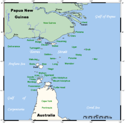
Hammond Island in der unteren Bildmitte.Hammond Island, von seinen Bewohnern Keriri genannt, ist eine kleine Insel im Süden des Archipels der Torres-Strait-Inseln. Sie liegt in der Untergruppe der Thursday-Inseln und ist von Thursday Island, der Hauptinsel in der Torres Strait, nur knapp einen Kilometer entfernt.
Die hügelige Insel ist etwa 6,2 Kilometer lang und bis zu 2,7 Kilometer breit. Kleinere Ansiedlungen finden sich an der Südostküste. 2001 lebten 204 Menschen auf der Insel.
Verwaltungstechnisch gehört Hammond Island zu den Inner Islands, der südlichsten Inselregion im Verwaltungsbezirk Torres Shire des australischen Bundesstaats Queensland.
Siehe auch
Weblinks
Inselregionen, Hauptinseln und Inselgruppen im Archipel der Torres-Strait-Inselnzu Papua-Neuguinea gehörige Torres-Strait-Inseln: Bristow Island | Daru Island | Parama Island • Kawai-Inseln | Talbot-Inseln
Top Western: Boigu | Dauan | Deliverance | Saibai | Turnagain • Talbot-Inseln
Western: Badu | Mabuiag | Moa | Portlock | Tobin • Bellevue-Inseln | Duncan-Inseln | Farewell-Inseln | Kulbi-Inseln
Central: Aureed | Bourke | Coconut | Sassie | Sue | Yam | Yorke • Bourke-Inseln | The Three Sisters | Yorke-Inseln
Eastern: Bramble | Darnley | Murray | Stephens • Murray-Inseln
Inner: Albany | Booby | Crab | Entrance | Friday | Goods | Hammond | Horn | Packe | Prince-of-Wales | Thursday | Wednesday • Manar-Inseln | Red-Wallis-Inseln | Thursday-Inseln | Tuesday-Inseln
Wikimedia Foundation.
Schlagen Sie auch in anderen Wörterbüchern nach:
Hammond (town), New York — Hammond is a town in St. Lawrence County, New York, United States. The population was 1,207 at the 2000 census. The name is derived from early land owner Abijah Hammond.The Town of Hammond is in the northwest corner of St. Lawrence County. The… … Wikipedia
Hammond River — The Hammond River is a New Brunswick river running approximately 40 kilometres in southern Kings County along the border of Saint John County.One of southern New Brunswick s best salmon rivers, the Hammond River rises in the Caledonia Highlands… … Wikipedia
Island Princess (steamboat) — Daily (upper) Island Princess (lower) Career … Wikipedia
Island Lake, Illinois — Coordinates: 42°16′40″N 88°12′3″W / 42.27778°N 88.20083°W / 42.27778; 88.20083 … Wikipedia
Thursday Island — Landsat Bild von Thursday Island (unten) und Hammond Island (oben) … Deutsch Wikipedia
Albany Island (Queensland) — w1 Albany Island Lage der Torres Strait Inseln Gewässer Pazifischer Ozean Inselgruppe … Deutsch Wikipedia
Boigu Island — Lage der Torres Strait Inseln: Boigu oben, Mitte. Gewässer Pazifischer Ozean Ins … Deutsch Wikipedia
Mer Island — w1 Murray Island (Mer) Lage der Torres Strait Inseln: Murray (Mer) Bildmitte, rechts. Gewässer Pazifischer Ozean … Deutsch Wikipedia
Mulgrave Island — w1 Badu Island Lage der Torres Strait Inseln: Badu Island in der Bildmitte, links. Gewässer Pazifischer Ozean … Deutsch Wikipedia
Stephen Island — w1 Stephen Island (Ugar) Lage der Torres Strait Inseln: Stephen Island (Ugar) Bildmitte, oben. Gewässer Pazifisc … Deutsch Wikipedia
Hammond Island

18+
© Academic, 2000-2026
- Kontaktieren Sie uns: Unterstützung, Werbung
Wörterbücher Export, schritte mit PHP, Joomla, Drupal, WordPress, MODx.