- Brisbane Road
-
Matchroom Stadium 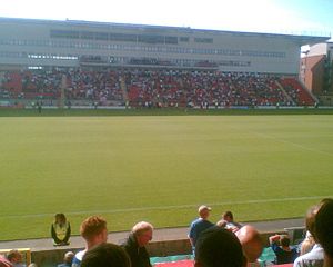
Daten Ort  London, England
Koordinaten 51° 33′ 36,5″ N, 0° 0′ 45,6″ W51.56015-0.01265833333332Koordinaten: 51° 33′ 36,5″ N, 0° 0′ 45,6″ W Eröffnung 1937 Kapazität 9.271 Spielfläche 110 × 76 Verein(e) Leyton Orient
Tottenham Hotspurs ReserveDie Brisbane Road (früher auch Osborne Road und aktuell Matchroom Stadium) ist das Stadion der englischen Fußballmannschaft Leyton Orient sowie der Reserve der Tottenham Hotspurs. Die Brisbane Road befindet sich im Stadtteil Leyton im Osten Londons.
Das Stadion wurde 1937 eröffnet und hat 9.271 Sitzplätze. Die Firma Matchroom Sport von Leyton Orient Präsident Barry Hearn ist aktueller Namenssponsor des Stadions.
Weblinks
 Commons: Brisbane Road – Sammlung von Bildern, Videos und Audiodateien
 Stadien der englischen Football League One in der Saison 2011/12
Seward Stadium (AFC Bournemouth) | Griffin Park (FC Brentford) | Gigg Lane (FC Bury) | Brunton Park (Carlisle United) | The Valley (Charlton Athletic) | B2net Stadium (FC Chesterfield) | Weston Homes Community Stadium (Colchester United) | St. James’ Park (Exeter City) | Victoria Park (Hartlepool United) | Galpharm Stadium (Huddersfield Town) | Matchroom Stadium (Leyton Orient) | Stadium:mk (Milton Keynes Dons) | Meadow Lane (Notts County) | Boundary Park (Oldham Athletic) | Deepdale (Preston North End) | Spotland Stadium (AFC Rochdale) | Glanford Park (Scunthorpe United) | Bramall Lane (Sheffield United) | Hillsborough Stadium (Sheffield Wednesday) | The Lamex Stadium (FC Stevenage) | Prenton Park (Tranmere Rovers) | Banks’s Stadium (FC Walsall) | Adams Park (Wycombe Wanderers) | Huish Park (Yeovil Town)
Wikimedia Foundation.
Schlagen Sie auch in anderen Wörterbüchern nach:
Brisbane Road — Full name Matchroom Stadium, Brisbane Road Location Leyton, London, E10 5NE Built 1937 … Wikipedia
Brisbane Road — Généralités Nom complet Matchroom Stadium, Brisbane Road Adresse Leyton, Londres, E10 5NE … Wikipédia en Français
Brisbane road routes 31-60 — Routes 31 to 40 = Australian road routes table extended state = Queensland route shield = AUSR31.png route type = State Route route number = 31 from locality = Dundas to locality = Brisbane via locality1 = Mount Glorious via locality2 = Mount… … Wikipedia
Brisbane road routes 1-30 — Routes 1 to 10 = Australian road routes table extended state = Queensland route shield = Qld M1.png route number = M1 route type = from locality = Cooroy to locality = Currumbin via locality1 = Caboolture via locality2 = Eagle Farm via locality3 … Wikipedia
Road routes in Brisbane — Brisbane s system of road routes is numbered mostly separately to the rest of the state, and the systems on the Gold Coast and Sunshine Coast. The route numbering is basically distributed as so (with a few exceptions):: Routes 1 6, 13 15: Major… … Wikipedia
Brisbane Tramway Museum — is a transport museum which preserves and displays trams and trolley buses, most of which operated in Brisbane, Queensland, Australia. The museum also has a collection of vehicles and other equipment used in maintaining Brisbane s electric street … Wikipedia
Brisbane central business district — Brisbane CBD Brisbane, Queensland Brisbane CBD from Kangaroo Point … Wikipedia
Brisbane North Institute of TAFE — is one of the largest vocational education and training organisations in Australia, serving more than 30,000 students across six campuses in the northern regions of Brisbane. Campuses are located at Bracken Ridge, Ithaca, Grovely (a neighbourhood … Wikipedia
Brisbane Forest Park — Brisbane Forest Park, which is located on part of the D Aguilar Range, is a large nature reserve on the western boundary of the City of Brisbane, bordering on the Mount Coot tha Reserve. Brisbane Forest Park supports a huge variety of plants and… … Wikipedia
Brisbane Boys’ College — Schulform Jungenschule, Internat Gründung Februar 1902 Ort Toowong Staat … Deutsch Wikipedia
Brisbane Road

18+
© Academic, 2000-2026
- Kontaktieren Sie uns: Unterstützung, Werbung
Wörterbücher Export, schritte mit PHP, Joomla, Drupal, WordPress, MODx.