- Arrondissement Condom
-
Arrondissement Condom Region Midi-Pyrénées Département Gers Unterpräfektur Condom Einwohner 64.598 (1. Jan. 2008) Bevölkerungsdichte 27 Einw./km² Fläche 2.437 km² Kantone 11 Gemeinden 159 INSEE-Code 322 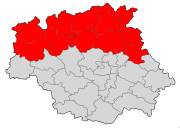
Lage des Arrondissements Condom im Département GersDas Arrondissement Condom ist eine Verwaltungseinheit des französischen Départements Gers innerhalb der Region Midi-Pyrénées. Verwaltungssitz (Unterpräfektur) ist Condom.
Es besteht aus elf Kantonen und 159 Gemeinden.
Kantone
- Cazaubon
- Condom
- Eauze
- Fleurance
- Lectoure
- Mauvezin
- Miradoux
- Montréal
- Nogaro
- Saint-Clar
- Valence-sur-Baïse

Albi | Argelès-Gazost | Auch | Bagnères-de-Bigorre | Cahors | Castelsarrasin | Castres | Condom | Figeac | Foix | Gourdon | Millau | Mirande | Montauban | Muret | Pamiers | Rodez | Saint-Gaudens | Saint-Girons | Tarbes | Toulouse | Villefranche-de-Rouergue
Wikimedia Foundation.
Schlagen Sie auch in anderen Wörterbüchern nach:
Condom (Arrondissement) — Arrondissement Condom Staat Frankreich Region Midi Pyrénées Département Gers Unterpräfektur Condom Einwohner – insgesamt – … Deutsch Wikipedia
Condom-en-Armagnac — Condom (Gers) Pour les articles homonymes, voir Condom. Condom Condom … Wikipédia en Français
Condom, Gers — Condom Condom Cathedral … Wikipedia
Condom — ist: eine andere Schreibweise für Kondom eine französische Gemeinde im Département Gers, siehe Condom (Gers) ein französischer Kanton im Département Gers, siehe Kanton Condom ein französisches Arrondissement, siehe Arrondissement Condom eine… … Deutsch Wikipedia
Condom (Gers) — Condom … Deutsch Wikipedia
Arrondissement Nérac — Region Aquitanien Département Lot et Garonne Unterpräfektur Nérac Einwohner 38.335 (1. Jan. 2008) Bevölkerungsdichte 27 Einw./km² Fläche … Deutsch Wikipedia
Arrondissement Agen — Region Aquitaine Département Lot et Garonne Präfektur Agen Einwohner 116.130 (1. Jan. 2008) Bevölkerungsdichte 115 Einw./km² Fläche … Deutsch Wikipedia
Condom (Gers) — Pour les articles homonymes, voir Condom. 43° 57′ 30″ N 0° 22′ 25″ E … Wikipédia en Français
Arrondissement De Condom — Administration Pays France Région Midi Py … Wikipédia en Français
Arrondissement de condom — Administration Pays France Région Midi Py … Wikipédia en Français
Arrondissement Condom

18+
© Academic, 2000-2026
- Kontaktieren Sie uns: Unterstützung, Werbung
Wörterbücher Export, schritte mit PHP, Joomla, Drupal, WordPress, MODx.