- Belgaum (Division)
-
Belgaum Division Bundesstaat: Karnataka Verwaltungssitz: Belgaum Fläche: 54.514 km² Einwohner: 13.042.163 Bevölkerungsdichte: 239 Einwohner/km² Distrikte: 7 Die Division Belgaum ist eine Division im indischen Bundesstaat Karnataka.
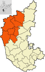
Distrikte
Die Division Belgaum gliedert sich in sieben Distrikte:
Distrikt Verwaltungssitz Fläche in km² Einwohner (2001) Ew./km² Bagalkot Bagalkot 6.575 1.651.892 251 Belgaum Belgaum 13.415 4.214.505 314 Bijapur Bijapur 10.494 1.806.918 172 Dharwad Hubli-Dharwad 4.260 1.604.253 377 Gadag Gadag 4.656 971.835 209 Haveri Haveri 4.823 1.439.116 298 Uttara Kannada Karwar 10.291 1.353.644 132 Schlagen Sie auch in anderen Wörterbüchern nach:
Belgaum Division — is one of the four divisions of karnataka state of India. The division comprises the districts of Bagalkot, Belgaum, Bijapur, Dharwad, Gadag, Haveri, and Uttara Kannada.ee also*Districts of Karnataka … Wikipedia
Belgaum district — Infobox Indian Jurisdiction type = district native name = Belgaum hq = Belgaum area total = 12000 latd = longd = locator position = left state name = Karnataka altitude = abbreviation = collector = population total = 4214505 population as of =… … Wikipedia
Belgaum — Belgaum, Distrikt in der südlichen Division der britisch ind. Präsidentschaft Bombay, 12,061 qkm groß. Der fast ganz ebene Distrikt wird nur von einzelnen, z. T. wohlbewaldeten, mit kleinen Forts gekrönten Hügelreihen durchzogen und von der… … Meyers Großes Konversations-Lexikon
Belgaum — Infobox Indian Jurisdiction native name=Belgaum latd = 15.55|longd=74.35 state name=Karnataka district=Belgaum leader title=Mayor leader name= Under DC Rule altitude=762 population as of = 2005 | population total = 564000 | area magnitude=1 E?… … Wikipedia
Mysore Division — Mysore district Mysore Division includes the districts of Mysore, Chamarajanagar, Mandya, Dakshina Kannada, Udupi, Kodagu, Chikmagalur and Hassan. The administrative headquarters of the division is Mysore. This division is home to :… … Wikipedia
Bangalore (Division) — Bangalore Division Bundesstaat: Karnataka … Deutsch Wikipedia
Gulbarga (Division) — Gulbarga Division Bundesstaat: Karnataka … Deutsch Wikipedia
Mysore (Division) — Mysore Division Bundesstaat: Karnataka V … Deutsch Wikipedia
List of districts of Karnataka — A map showing the 30 districts of Karnataka. The Indian State of Karnataka is located within 11°30 North and 18°30 North latitudes and 74° East and 78°30 East longitude. It is situated on a tableland where the Western and Eastern Ghat ranges… … Wikipedia
Uttara Kannada — North Kanara district … Wikipedia