Deming (New Mexico)

Deming (New Mexico)
Icon tools.svg Dieser Artikel wurde aufgrund von inhaltlichen Mängeln auf der Qualitätssicherungsseite des Projektes USA eingetragen. Hilf mit, die Qualität dieses Artikels auf ein akzeptables Niveau zu bringen, und beteilige dich an der Diskussion!
US-GreatSeal-Obverse.svg
Deming
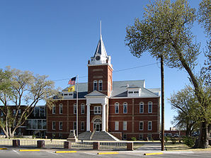
Luna County Courthouse
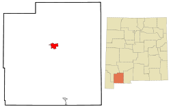
Lage in New Mexico
Luna County New Mexico Incorporated and Unincorporated areas Deming Highlighted.svg
Basisdaten
Gründung: 1881
Staat: Vereinigte Staaten
Bundesstaat: New Mexico
County:

Luna County

Koordinaten: 32° 16′ N, 107° 45′ W32.261111111111-107.755833333331321Koordinaten: 32° 16′ N, 107° 45′ W
Zeitzone: Mountain Standard Time (UTC−7)
Einwohner: 14.116 (Stand: 2000)
Bevölkerungsdichte: 583,3 Einwohner je km²
Fläche: 24,2 km² (ca. 9 mi²)
davon 24,2 km² (ca. 9 mi²) Land
Höhe: 1321 m
Postleitzahlen: 88030-88031
Vorwahl: +1 505, 575
FIPS: 35-20270
GNIS-ID: 0920584
Webpräsenz: www.cityofdeming.org
Bürgermeister: Andres Z. Silva

Deming (auch New Chicago[1]) ist eine Stadt im US-Bundesstaat New Mexico im Luna County mit 14.116 Einwohnern. Die Stadt ist auch Sitz der County-Verwaltung (County Seat) des Luna County.

Deming ist Geburtsort des Songwriters Nacio Herb Brown. Eine Sehenswürdigkeit Demings ist die spanische Disco, eine der wenigen restlichen Discos im County.

Einzelnachweise

  1. N.M. Geographic Names Data Base, 1992. Compiled by Bob Julyan over more than five years of researching individual geographic names in New Mexico. Especially useful for historical names, name changes; and variants. Subsumed within this bibliographical reference is the much larger bibliography of the data base, comprising 235 references, including county histories, local histories, other historical works, correspondence, and numerous oral sources

Weblinks

 Commons: Deming – Sammlung von Bildern, Videos und Audiodateien

Wikimedia Foundation.

Игры ⚽ Нужна курсовая?

Schlagen Sie auch in anderen Wörterbüchern nach:

  • Deming, New Mexico — The City of Deming   City   Sunset at the Sonic Drive In, Deming …   Wikipedia

  • Camp Cody Deming New Mexico — Camp Cody, located 3 miles northwest of Deming, New Mexico. Important World War One Army camp from 1916 to 1918.HistoryDuring World War One, Camp Cody was an army training camp for the National Guard units from North and South Dakota, Nebraska,… …   Wikipedia

  • New Mexico wine — New Mexico (wine region) Southern New Mexico Vineyard Official name State of New Mexico Type …   Wikipedia

  • New Mexico Airlines — IATA LW ICAO NMI Callsign TSUNAMI …   Wikipedia

  • New Mexico locations by per capita income — New Mexico has the fifth lowest per capita income in the United States of America, at $17,261 (2000). Its personal per capita income is $25,541 (2003). Contents 1 New Mexico counties ranked by per capita income 2 New Mexico places ranked by Per… …   Wikipedia

  • New Mexico Airlines — IATA LW OACI NMI Indicativo TSUNAMI Fundación 2007 …   Wikipedia Español

  • New Mexico World War II Army Airfields — Part of World War II Type Army A …   Wikipedia

  • New Mexico — • A state of the United States Catholic Encyclopedia. Kevin Knight. 2006. New Mexico     New Mexico     † …   Catholic encyclopedia

  • New Mexico State Police — Abbreviation NMSP Patch of the New Mexico State Police …   Wikipedia

  • New Mexico House of Representatives — New Mexico State Legislature Type Type Lower House Term limits None New session started …   Wikipedia

Share the article and excerpts

Direct link
Do a right-click on the link above
and select “Copy Link”