- Foni Kansala
-
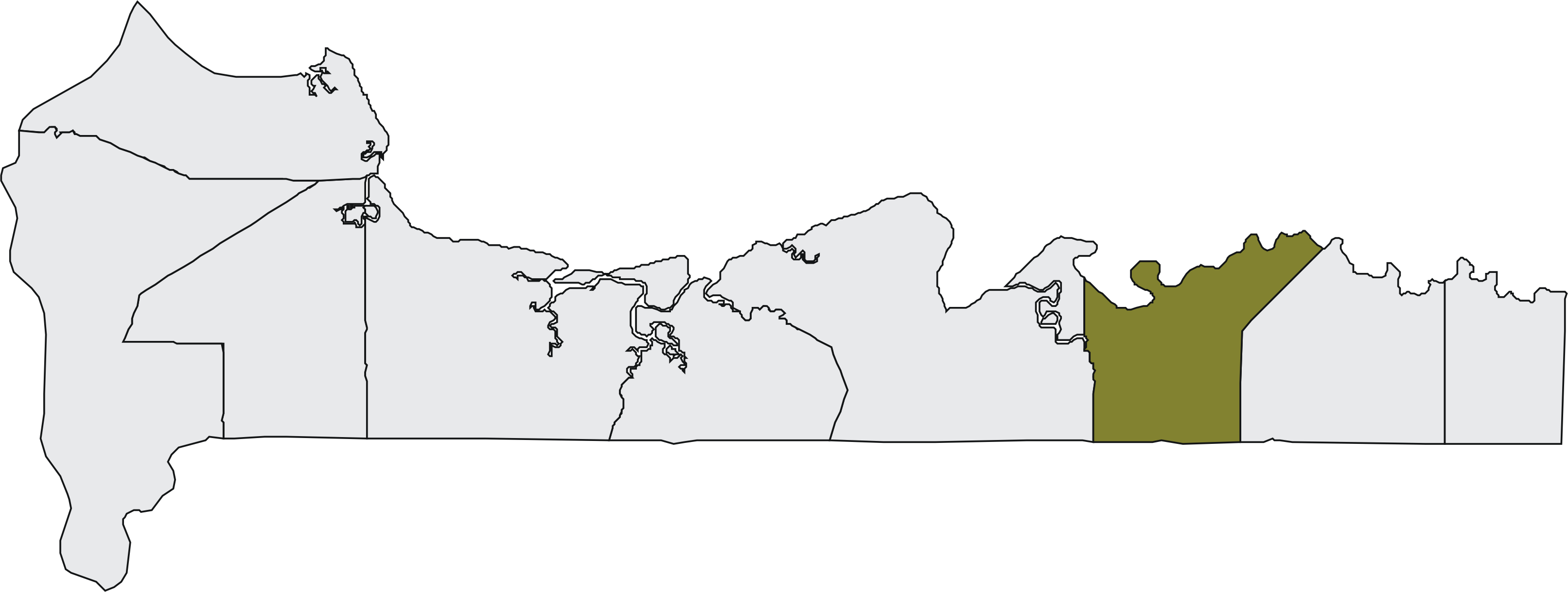
Foni Kansala 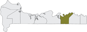 Lage des Distrikts in der West Coast Region

Lage des Distrikts in GambiaBasisdaten Übergeordnete Region West Coast Region Geographische Lage 13° 13′ N, 16° 3′ W13.216666666667-16.05Koordinaten: 13° 13′ 0″ N, 16° 3′ 0″ W Einwohnerzahl 15.780 (Stand 2010) Foni Kansala ist einer von 35 Distrikten – der zweithöchsten Ebene der Verwaltungsgliederung – im westafrikanischen Staat Gambia. Es ist einer von neun Distrikten in der West Coast Region.
Nach einer Berechnung von 2010 leben dort etwa 15.780 Einwohner, das Ergebnis der letzten veröffentlichten Volkszählung von 2003 betrug 12.247.[1]
Der Name ist von Foni abgeleitet, einem ehemaligen kleinen Reich.
Ortschaften
Die zehn größten Orte sind:
- Bwiam, 3970
- Sanajor, 1405
- Kankuntu, 892
- Kanilai, 836
- Kamfenda, 813
- Dasilami, 774
- Burock, 682
- Dobong, 656
- Kamfenda Baji Kunda, 425
- Kampant, 386
- siehe auch Liste der Städte in Gambia
Bevölkerung
Nach einer Erhebung von 1993[2] (damalige Volkszählung) stellt die größte Bevölkerungsgruppe die der Jola mit einem Anteil von rund sieben Zehnteln, gefolgt von den Mandinka und den Fula. Die Verteilung im Detail: 13,7 % Mandinka, 5,6 % Fula, 3 % Wolof, 71,9 % Jola, 2,5 % Serahule, 0,9 % Serer, 0 % Aku, 0,7 % Manjago, 0,3 % Bambara und 1,4 % andere Ethnien.
Einzelnachweise
- ↑ Foni Kansala in World Gazetteer, Zugriff Juni 2010
- ↑ Population by Ethnicity, by Settlement and Local Government Area. (Gambians Only) PDF-Datei
 Distrikte der West Coast Region
Kombo North | Kombo South | Kombo Central | Kombo East | Foni Brefet | Foni Bintang-Karanai | Foni Kansala | Foni Bondali | Foni Jarrol
Wikimedia Foundation.
Schlagen Sie auch in anderen Wörterbüchern nach:
Foni Kansala — is one of the nine districts of The Gambia s Western Division, which is located to the south of the Gambia River in the southwest of the country. Foni Kansala is in the southeast of the division, between Foni Bintang Karenai and Foni Bondali … Wikipedia
Foni Kansala — Admin ASC 2 Code Orig. name Foni Kansala Country and Admin Code GM.05.2413477 GM … World countries Adminstrative division ASC I-II
Foni Bintang-Karanai — Lage des Distrikts in der West Coast Region … Deutsch Wikipedia
Foni Bondali — Lage des Distrikts in der West Coast Region … Deutsch Wikipedia
Foni Brefet — Lage des Distrikts in der West Coast Region … Deutsch Wikipedia
Foni Jarrol — Lage des Distrikts in der West Coast Region … Deutsch Wikipedia
Foni (Begriffsklärung) — Foni steht für: ein historisches afrikanisches Reich, siehe Foni die gambischen Distrikte Foni Brefet, Foni Bintang Karanai, Foni Kansala,Foni Bondali und Foni Jarrol, siehe West Coast Region Alfredo Foni, italienischer Fußballspieler … Deutsch Wikipedia
Foni Bintang-Karenai — is one of the nine districts of The Gambia s Western Division, which is located to the south of the Gambia River in the southwest of the country. Foni Bintang Karenai is in the central south of the division, between Foni Kansala and Foni Brefet … Wikipedia
Foni Bondali — is one of the nine districts of The Gambia s Western Division, which is located to the south of the Gambia River in the southwest of the country. Foni Bondali is in the southeast of the division, between Foni Kansala and Foni Jarrol … Wikipedia
Foni — Alte Karte von der Region aus dem Andrees Allgemeiner Handatlas (1881) Foni (Schreibvarianten: Fogni, Fogny oder Fooñi) war ein historisches Reich im westafrikanischen Staat Gambia. Geschichte Das Reich war im frühen 19. Jahrhundert eines der… … Deutsch Wikipedia
Foni Kansala

18+
© Academic, 2000-2026
- Kontaktieren Sie uns: Unterstützung, Werbung
Wörterbücher Export, schritte mit PHP, Joomla, Drupal, WordPress, MODx.