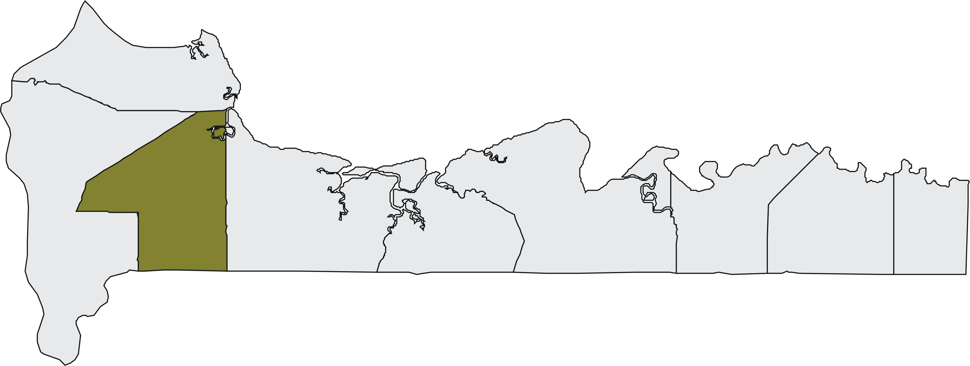
- Kombo Central
-
Kombo Central 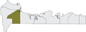 Lage des Distrikts in der West Coast Region

Lage des Distrikts in GambiaBasisdaten Übergeordnete Region West Coast Region Geographische Lage 13° 15′ N, 16° 40′ W13.25-16.666666666667Koordinaten: 13° 15′ 0″ N, 16° 40′ 0″ W Einwohnerzahl 104.589 (Stand 2010) Kombo Central ist einer von 35 Distrikten – der zweithöchsten Ebene der Verwaltungsgliederung – im westafrikanischen Staat Gambia. Es ist einer von neun Distrikten in der West Coast Region.
Nach einer Berechnung von 2010 leben dort etwa 104.589 Einwohner, das Ergebnis der letzten veröffentlichten Volkszählung von 2003 betrug 84.315.[1]
Der Name ist von Kombo abgeleitet, einem ehemaligen kleinen Reich.
Ortschaften
Die zehn größten Orte sind:
- Brikama, 94.838
- Kembujeh, 3903
- Kitty, 3365
- Dasilameh, 3080
- Mara Kissa, 2220
- Busura, 2187
- Manduar, 2185
- Madina, 1129
- Penyem, 1092
- Nyonfellah Madina, 942
- siehe auch Liste der Städte in Gambia
Bevölkerung
Nach einer Erhebung von 1993[2] (damalige Volkszählung) stellt die größte Bevölkerungsgruppe die der Mandinka mit einem Anteil von rund fünf Zehnteln, gefolgt von den Jola und den Fula. Die Verteilung im Detail: 49,2 % Mandinka, 12,8 % Fula, 5 % Wolof, 21,8 % Jola, 1,7 % Serahule, 1,9 % Serer, 0,3 % Aku, 4,9 % Manjago, 0,4 % Bambara und 2 % andere Ethnien.
Einzelnachweise
- ↑ Kombo Central in World Gazetteer, Zugriff Juni 2010
- ↑ Population by Ethnicity, by Settlement and Local Government Area. (Gambians Only) PDF-Datei
 Distrikte der West Coast Region
Kombo North | Kombo South | Kombo Central | Kombo East | Foni Brefet | Foni Bintang-Karanai | Foni Kansala | Foni Bondali | Foni Jarrol
Wikimedia Foundation.
Schlagen Sie auch in anderen Wörterbüchern nach:
Kombo Central — is one of the nine districts of The Gambia s Western Division, which is located to the south of the Gambia River in the southwest of the country. Kombo Central is in the southwest of the division, between Kombo East and Kombo South … Wikipedia
Kombo Central District — Admin ASC 2 Code Orig. name Kombo Central District Country and Admin Code GM.05.2412852 GM … World countries Adminstrative division ASC I-II
Kombo East — Lage des Distrikts in der West Coast Region … Deutsch Wikipedia
Kombo North — Lage des Distrikts in der West Coast Region … Deutsch Wikipedia
Kombo South — Lage des Distrikts in der West Coast Region … Deutsch Wikipedia
Kombo East — is one of the nine districts of The Gambia s Western Division, which is located to the south of the Gambia River in the southwest of the country. Kombo East is in the central south of the division, between Kombo Central and Foni Brefet … Wikipedia
Kombo South — is one of the nine districts of The Gambia s Western Division, which is located to the south of the Gambia River in the southwest of the country. Kombo South is in the southwest of the division, between Kombo Central and Kombo North/Saint Mary.… … Wikipedia
Kombo — Alte Karte der Region aus dem Andrees Allgemeiner Handatlas (1881) Kombo (Schreibvariante Combo) war ein kleines Reich im heutigen westafrikanischen Staat Gambia, an der Mündung des Gambia Flusses. Die heutigen Distrikte Kombo Central, Kombo East … Deutsch Wikipedia
Central African Republic — a republic in central Africa: a member of the French Community. 3,342,051; 238,000 sq. mi. (616,420 sq. km). Cap.: Bangui. Formerly, Central African Empire, Ubangi Shari. * * * Central African Republic Introduction Central African Republic… … Universalium
Central African Republic — <p></p> <p></p> Introduction ::Central African Republic <p></p> Background: <p></p> The former French colony of Ubangi Shari became the Central African Republic upon independence in 1960. After… … The World Factbook
Kombo Central

18+
© Academic, 2000-2024
- Kontaktieren Sie uns: Unterstützung, Werbung
Wörterbücher Export, schritte mit PHP, Joomla, Drupal, WordPress, MODx.