- Forgottonia
-
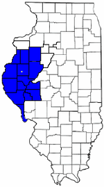 Die Countys von Forgottonia (blau gefärbt) auf einer Karte von Illinois, der weiße Punkt in der Mitte zeigt den Standort der Hauptstadt Fandon
Forgottonia (auch Forgotonia oder Republic of Forgottonia, abgeleitet von englisch forgotten ‚vergessen‘) ist der Name eines fiktiven US-Bundesstaates, den der US-amerikanische Student Neal Gamm 1971 aus Protest über die Verkehrsanbindung im westlichen Teil von Illinois ausrief.
Geschichte
Ende der 1960er, Anfang der 1970er Jahre wurden hohe Investitionen in die Infrastruktur des Staates Illinois getätigt, wobei der Großteil des Geldes in den Ausbau der Transportwege in den Raum Chicago floss.[1] Die Einwohner des westlichen Teils des Bundesstaates fühlten sich vernachlässigt, der regelmäßige Zugverkehr aus ihrer Region nach Chicago wurde eingestellt und der Bau eines Highways von Chicago nach Kansas City durch ihre Heimatregion zweimal abgelehnt.[2] Eine Neufassung der Verfassung von Illinois aus dem Jahr 1970 ermöglichte den Zusammenschluss von mehreren Countys, um ihre regionalen Interessen besser vertreten zu können. Der erste dieser Zusammenschlüsse war das Western Illinois Regional County, das aus sechs Countys im Westen von Illinois bestand.[1] An deren Gebiet grenzten die 16 Countys an, die zu der vom 25-jährigen Studenten Neal Gamm 1971 ausgerufenen Republik Forgottonia gehörten.[3] Gamm ernannte sich zum Gouverneur und bestimmte Fandon, eine kleine gemeindefreie Siedlung südlich der Stadt Colchester im McDonough County zur Hauptstadt.[2] Seine Unterstützer druckten den Namen Forgottonia auf Briefmarken und stellten an den Grenzen des fiktiven Bundesstaates Schilder auf, die Autofahrer darauf hinwiesen, dass sie sich nun in Forgottonia befinden. Das Vergissmeinnicht wurde zur Staatsblume, der Albatros zum Wappentier erkoren.[2] Außenwirkung erreichte Forgottonia durch den Bürgermeister von Canton, der die Aktion als wirksame Staatsgründung ansah und öffentlich dagegen opponierte. Weitere Aufmerksamkeit erhielt die Initiative durch Douglas Kane, Mitglied des Repräsentantenhauses von Illinois, der errechnete, dass die westlichen Countys von Illinois mehr an staatlichem Geld erhalten hätten als sie an Steuern zahlen.[1] Im Sommer 1972 nach rund einem Jahr ließ das öffentliche Interesse an Forgottonia nach und mit der Gründung von Amtrak wurden die Zugverbindungen wieder aufgenommen.[4] Noch heute zählt der Westen von Illinois zu den unterentwickeltsten Regionen der USA und die Einwohner nennen sie nach wie vor Forgottonia.[5]
Einzelnachweise
- ↑ a b c James L. Erwin: Declarations of Independence: Encyclopedia of American Autonomous and Secessionist Movements. Greenwood Publishing, 2007, ISBN 978-0-313332-67-8, S. 51.
- ↑ a b c Richard Moreno: Illinois Curiosities: Quirky Characters, Roadside Oddities & Other Offbeat Stuff. Globe Pequot, 2011, ISBN 9780762758616, S. 134f.
- ↑ James D. Nowlan: From Lincoln to Forgottonia. In: Illinois Issues. September 1998, S. 27-30 (online).
- ↑ Nathan Woodside: When we seceded: Remembering Forgottonia. The McDonough County Voice, 28. Dezember 2010, abgerufen am 24. Oktober 2011 (englisch).
- ↑ Michael Kleen: Haunting the Prairie: A Tourist's Guide to the Weird and Wild Places of Illinois. Black Oak Media, 2010, ISBN 978-0-979040-14-6, S. 62.

Wikimedia Foundation.