- Gougaram
-
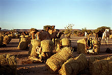
Gougaram (auch: Goûgaram) ist ein Dorf und gleichzeitig Militärstation für Kontrollzwecke im nördlichen Sektor des Departements Arlit, zwischen Arlit, Iferouane und der Hauptstadt der Region, Agadez am Westrand des Air-Gebirge im Niger. Im Umkreis dieses Wüstensiedlungspunktes leben keine 100 Menschen. Gleichwohl hat Gougaram eine Grundschule für das Bildungswesen.[1]
In der Region herrscht das Klima des Sahel vor, mit hohen Temperaturen und niedrigen, unregelmäßigen Niederschlägen zwischen 50 und 100 mm Regen pro Jahr[2].
Weblinks
Einzelnachweise
18.48257.7844444444444Koordinaten: 18° 29′ N, 7° 47′ OSchlagen Sie auch in anderen Wörterbüchern nach:
Diffa — Urban Commune … Wikipedia
N'guigmi — Nguigmi, Ngigmi Camel riders line up outside the residence of the traditional chief of Nguigmi … Wikipedia
Dosso, Niger — Dosso Officials at the opening of the Regional Maternity hospital, 2008 … Wikipedia
Djado Plateau — The ruined city of Djado, with nomadic women gathered in the foreground. October 1989. The Djado Plateau lies in the Sahara, in north eastern Niger. It is known for its cave art (often of large mammals long since absent from the area), but is now … Wikipedia
Dakoro — is a town and commune located in the Maradi Region of Niger. Coordinates: 14°30′N 6°45′E / … Wikipedia
Dogondoutchi — Dogondoutchi … Wikipedia
Mayahi — (var. Mayaki) is a town located in the Maradi Region of Niger. It is the seat of Mayahi Department and a Commune about 45km from Tessaoua. In the mid 1990s it had a population of 2,200.[1] The name Mayaki is also a rulers title among the Sudié… … Wikipedia
Communes of Niger — Niger This article is part of the series: Politics and government of Niger Constitution President … Wikipedia
Ouallam — is a town in southwestern Niger. It is around 300 km north of Niamey, is the capital of Ouallam Department, one of four in the Tillabery Region. Contents 1 Culture 2 Agricultural center 3 Intercommunal violence … Wikipedia
Matankari — is a town in southwestern Niger. It is near the city of Niamey. Coordinates: 13°48′22″N 4°01′55″E / 13.806075°N 4.031982°E / 13.806075 … Wikipedia