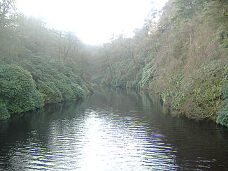
Goyt

Goyt
Goyt
River Goyt

River GoytVorlage:Infobox Fluss/KARTE_fehlt

DatenVorlage:Infobox Fluss/GKZ_fehlt
Lage Derbyshire und Greater Manchester, England
Flusssystem Mersey
Abfluss über Mersey → Irische See
Quelle in den Mooren von Axe Edge, ungefähr
53° 14′ 24″ N, 1° 59′ 34″ W53.239862-1.99267520
Quellhöhe 520 m ASL[1]
Zusammenfluss in Stockport mit dem Tame zum Mersey
53.414305555556-2.156666666666740

53° 24′ 52″ N, 2° 9′ 24″ W53.414305555556-2.156666666666740
Mündungshöhe 40 m ASL[2]
Höhenunterschied 480 mVorlage:Infobox Fluss/LÄNGE_fehltVorlage:Infobox Fluss/EINZUGSGEBIET_fehlt

Vorlage:Infobox Fluss/ABFLUSS_fehlt

Rechte Nebenflüsse Etherow
Durchflossene Stauseen Errwood Reservoir, Fernilee Reservoir

Der Goyt ist ein Fluss im Nordwesten Englands und, zusammen mit dem Etherow und dem Tame, einer der drei Quellflüsse des Mersey. Er entspringt in den Mooren von Axe Edge in einer Gegend, die als oberes Goyttal bekannt ist. Nach seiner Vereinigung mit dem Etherow fließt er bei Stockport mit dem Tame zusammen, um dann als Mersey weiterzufließen.

Belege

  1. Environment Agency (März 2004): The Tame, Goyt and Etherow catchement abstraction management strategy (Englisch) (PDF) S. 6. Environment Agency North West, Warrington. Abgerufen am 13. März 2007.
  2. Boyce, D (August 2005): Mersey and Bollin Catchment abstraction management strategy (Englisch) (PDF) S. 5. Environment Agency North West, Warrington. Abgerufen am 21. August 2010.

Wikimedia Foundation.

Игры ⚽ Нужна курсовая?

Schlagen Sie auch in anderen Wörterbüchern nach:

  • Göytəpə — or Gëytepe may refer to: *Göytəpə, Agdam, Azerbaijan *Göytəpə, Ismailli, Azerbaijan *Göytəpə, Jalilabad, Azerbaijan …   Wikipedia

  • Göytəpə, Agdam — Infobox Settlement official name =Göytəpə native name = pushpin pushpin mapsize =300 subdivision type = Country subdivision name = flag|Azerbaijan subdivision type1 = Rayon subdivision name1 =Agdam leader title = leader name = established title …   Wikipedia

  • Göytəpə, Ismailli — Infobox Settlement name =Göytəpə settlement type=Municipality native name = pushpin pushpin mapsize =300 subdivision type = Country subdivision name = flag|Azerbaijan subdivision type1 = Rayon subdivision name1 =Ismailli leader title = leader… …   Wikipedia

  • Göytəpə, Jalilabad — Infobox Settlement name =Göytəpə settlement type=Municipality native name = pushpin pushpin mapsize =300 subdivision type = Country subdivision name = flag|Azerbaijan subdivision type1 = Rayon subdivision name1 =Jalilabad leader title = leader… …   Wikipedia

  • Goyt (Fluss, Yorkshire) — Der Goyt ist ein Fluss im Nordwesten Englands und, zusammen mit dem Etherow und dem Tame, einer der drei Quellflüsse des Mersey. Er entspringt in den Mooren von Axe Edge in einer Gegend, die als oberes Goyttal bekannt ist. Nach seiner Vereinigung …   Deutsch Wikipedia

  • goyt —  the stream of a water mill. York, West Riding. Called GOWTE at Bristol …   A glossary of provincial and local words used in England

  • goyt — …   Useful english dictionary

  • River Goyt — Infobox River river name = River Goyt |200px caption = origin = Pennines mouth = River Mersey basin countries = England length = elevation = 520mcite web url = http://publications.environment agency.gov.uk/epages/eapublications.storefront/45f71ee5… …   Wikipedia

  • Upper Goyt Valley — The Upper Goyt Valley is the valley of the River Goyt in north west England.The western side of the valley is a long ridge, running from Shining Tor to Windgather Rocks, which forms the county boundary between Derbyshire and Cheshire; the… …   Wikipedia

  • New Mills — For other uses, see New Mills (disambiguation). Coordinates: 53°22′01″N 2°00′25″W / 53.367°N 2.007°W / 53.367; 2.007 …   Wikipedia

Share the article and excerpts

Direct link
Do a right-click on the link above
and select “Copy Link”