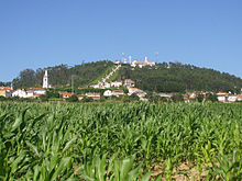
Laundos

Laundos
Laundos
Wappen Karte
Das Wappen fehlt noch Lagekarte für Laundos
Basisdaten
Region: Norte
Unterregion: Grande Porto
Distrikt: Porto
Concelho: Póvoa de Varzim
Koordinaten: 41° 26′ N, 8° 43′ W41.434336-8.722819Koordinaten: 41° 26′ N, 8° 43′ W
Einwohner: 2.131 (Stand: 2001)
Fläche: 8,6 km²
Bevölkerungsdichte: 248 Einwohner pro km²

Vorlage:Infobox Ort in Portugal/Wartung/Art ist leer

Vorlage:Infobox Ort in Portugal/Wartung/Karte ist ausgefüllt


Vorlage:Infobox Ort in Portugal/Wartung/Höhe ist leer Vorlage:Infobox Ort in Portugal/Wartung/PLZ ist leer Vorlage:Infobox Ort in Portugal/Wartung/Bürgermeister ist leer

Vorlage:Infobox Ort in Portugal/Wartung/Einwohnerstand ist leer

Vorlage:Infobox Ort in Portugal/Wartung/Verwaltungsort ist leer Vorlage:Infobox Ort in Portugal/Wartung/Webseite ist leer Vorlage:Infobox Ort in Portugal/Wartung/Email ist leer

Laundos ist eine Gemeinde im Norden Portugals.

Laundos

Laundos gehört zum Kreis Póvoa de Varzim im Distrikt Porto, besitzt eine Fläche von 8,6 km² und hat 2.131 Einwohner (Stand: 2001).[1]

Einzelnachweise

  1. Daten zu Laundos. alea.pt, abgerufen am 5. Juni 2011 (englisch).

Weblinks


Wikimedia Foundation.

Игры ⚽ Нужен реферат?

Schlagen Sie auch in anderen Wörterbüchern nach:

  • Laundos — Freguesia de Portugal Entidad Freguesia  • País …   Wikipedia Español

  • Laundos — Infobox Parish pt official name = Laundos image coat of arms = Brasao PVZ Laundos.jpg Municipality = Póvoa de Varzim area total = 9.69 population total = 2,131 (2001) population density = 219.9 website = none footnotes =Laundos or Laúndos is a… …   Wikipedia

  • Castro de Laundos — Saltar a navegación, búsqueda El Castro de Laundos es un poblado castreño del siglo II a. C., situado en un monte con 200 metros de altitud, en la freguesia de Laundos, Póvoa de Varzim, Portugal. Casi nada se sabe sobre la estructura… …   Wikipedia Español

  • Póvoa de Varzim — Saltar a navegación, búsqueda Póvoa de Varzim …   Wikipedia Español

  • Póvoa de Varzim — ] Culture and contemporary lifeJunqueira is Póvoa de Varzim s busiest and most traditional shopping district, the main street opened in the 18th century and is a pedestrian area since 1955. Currently, it has about 1 km (or 0.62 mi) of pedestrian… …   Wikipedia

  • Cividade de Terroso — Present day ruins of Cividade. The city s fall was the basis of the book Uma Deusa na Bruma (A Goddess in the Mist) by João Aguiar …   Wikipedia

  • Geography of Póvoa de Varzim — Póvoa de Varzimcoord|41|22|59|N|8|46|00|W|display=title, with an area of 82.06 square kilometres, lies between the Cávado and Ave rivers, or, from a wider perspective, halfway between the Minho and Douro rivers on the northern coast of Portugal… …   Wikipedia

  • Economy of Póvoa de Varzim — In 2001, the population working in the primary sector, industries and other similar activities made up almost 39% of the population of Póvoa de Varzim, while 46% of the population (plus 27% in related activities) worked in civil construction,… …   Wikipedia

  • Civil Parishes of Póvoa de Varzim — Map with the 12 civil parishes of Póvoa de Varzim Póvoa de Varzim is divided into twelve civil parishes. These are grouped in two areas: urban (city) and rural. Between 1308 and 1836, the municipality was made up of a single parish territory of… …   Wikipedia

  • Лаундуш — Район Лаундуш Laundos Страна ПортугалияПортугалия …   Википедия

Share the article and excerpts

Direct link
Do a right-click on the link above
and select “Copy Link”