- Linua
-
Linua Karte der Torres-Inseln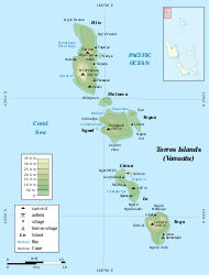
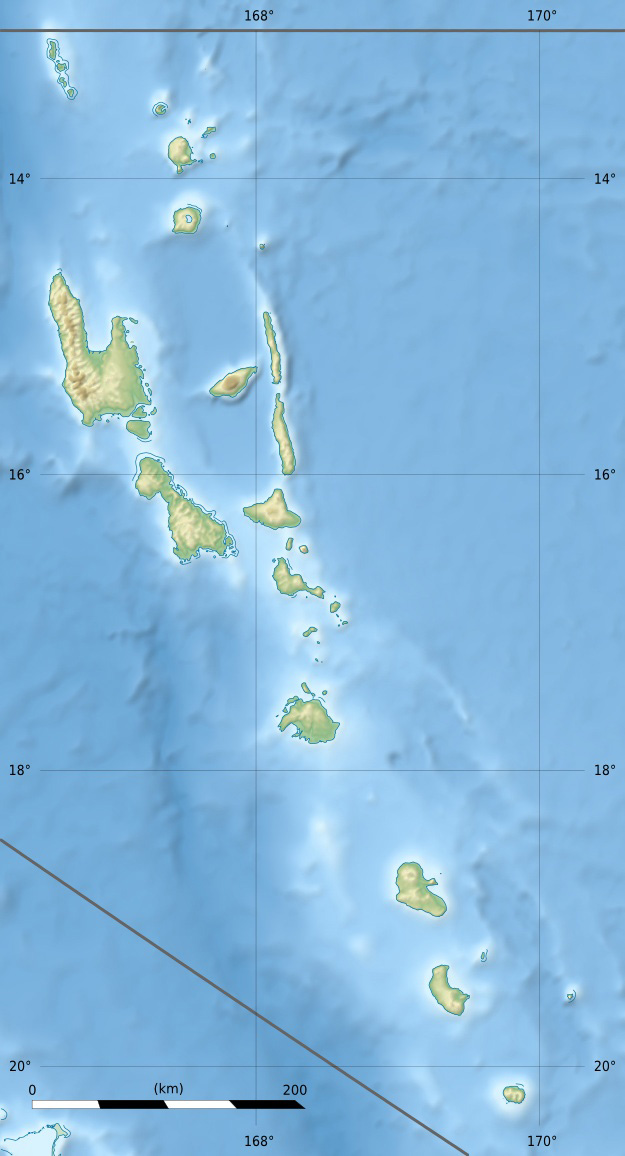
Linua in der BildmitteGewässer Korallenmeer Inselgruppe Torres-Inseln Geographische Lage 13° 19′ 36″ S, 166° 37′ 55″ O-13.326666666667166.6319444444426Koordinaten: 13° 19′ 36″ S, 166° 37′ 55″ O 

Länge 2,7 km Breite 900 m Fläche 2,5 km² Höchste Erhebung 26 m Hauptort unbewohnt Linua, vereinzelt auch Linaua genannt, ist eine unbewohnte Insel des pazifischen Inselstaats Vanuatu. Sie liegt sechs Kilometer südlich der Insel Tegua im Zentrum der Torres-Inseln, welche geopolitisch zur vanuatuischen Provinz Torba zählen.
Die Insel erstreckt sich von West nach Ost über etwa 2,7 Kilometer und ist maximal 900 Meter breit. Linua ist nur durch eine etwa 100 m breite, flache Sandbank von ihrer südlichen Nachbarinsel Loh getrennt. Außer bei Hochwasser ist eine Passage zu Fuß möglich.
Auf Linua befindet sich das kleine Flugfeld der Torres-Inseln, das Linua Airfield[1], auch Torres Airstrip (TOH)[2] genannt.
Abgesehen von ein paar für Touristen im Westen der Insel errichteten Ferienhütten ist Linua unbewohnt.[3]
Einzelnachweise
- ↑ Michelle Bennett, Jocelyn Harewood: Vanuatu, S. 164
- ↑ Flughafendaten im Aviation Safety Network
- ↑ Jocelyn Harewood: Vanuatu and New Caledonia, S. 96
Schlagen Sie auch in anderen Wörterbüchern nach:
Islas Torres — No debe confundirse con Islas de Torres (Uruguay) o Islas del Estrecho de Torres (Australia). Islas Torres (Torres Islands) Localización geográfica / administrativa Océano (mar) Océano Pacíf … Wikipedia Español
Torres Islands — For the island group between Australia and New Guinea, see Torres Strait Islands. Coordinates: 13°15′S 166°37′E / 13.25°S 166.617°E / … Wikipedia
Loh (Insel) — Loh Karte der Torres Inseln Loh (Lo) in der Bildmitte Gewässer Korallenmeer … Deutsch Wikipedia
Loh — Pour les articles homonymes, voir LO. Loh Lo Carte des îles Torres … Wikipédia en Français
Torres-Inseln (Vanuatu) — Torres Inseln Topographische Karte der Torres Inseln Gewässer Korallenmeer … Deutsch Wikipedia
Torres Islands — ▪ islands, Vanuatu northernmost group of Vanuatu, southwestern Pacific Ocean, about 60 miles (100 km) north of Espiritu Santo. They extend for 35 miles (56 km) and comprise Hiu (Hiw), the largest at 10 miles (16 km) long by 2 miles (3 km)… … Universalium
Tegua — Tugue Carte des îles Torres. Tegua est la plus au centre. Géographie Pays … Wikipédia en Français
Îles Torres — Ne pas confondre avec les îles du Détroit de Torrès en Australie. Pour les articles homonymes, voir Torres. îles Torres Torres Islands … Wikipédia en Français
Islands of Vanuatu — This is a list of the islands by province, largely from north to south, subdivided by archipelago when appropriate. Vanuatu is usually said to contain 83 islands. *Torba Province **Torres Islands ***Hiw ***Metoma ***Tegua ***Nmwel (uninhabited)… … Wikipedia
Jupiter (Mythologie) — Jupiter (römische Kamee) Jupiter (lateinisch Iuppiter, seltener Iupiter, Genitiv: Iovis) oder Diēspiter, seltener Juppiter, oft mit erweitertem Namen Iuppiter Optimus Maximus („bester und größter Jupiter“; in Inschriften meist abgekürzt zu IOM),… … Deutsch Wikipedia
Linua

18+
© Academic, 2000-2026
- Kontaktieren Sie uns: Unterstützung, Werbung
Wörterbücher Export, schritte mit PHP, Joomla, Drupal, WordPress, MODx.