Majdal Anjar

Majdal Anjar
Majdal Anjar
مجدل عنجر
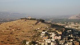
Majdalanjarcastle.jpg
Staat: Libanon Libanon
Gouvernement: Bekaa
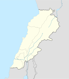
Koordinaten: 33° 42′ N, 35° 54′ O33.70749166666735.904008333333970Koordinaten: 33° 42′ N, 35° 54′ O
Höhe: 970 m
Fläche: 25,6 km²
 
Einwohner: 23.000 (2006)
Bevölkerungsdichte: 898 Einwohner je km²
Zeitzone: UTC+2
 
Bürgermeister: Sami El Ajame
Webpräsenz:
Majdal Anjar (Libanon)
Majdal Anjar
Majdal Anjar

Majdal Anjar (arabisch ‏مجدل عنجر‎, auch Majdel Anjar transkribiert) ist eine Mittelstadt im Distrikt Zahlé des Governorats Bekaa in der Bekaa-Ebene im Libanon mit 23.000 Einwohnern (2006).

Die Stadt liegt mit einem Areal von 25,64 km² an der Straßenverbindung BeirutDamaskus etwa 5 km vor der syrischen Grenze – die Grenzstation Masnaa liegt unmittelbar hinter der Stadt – auf einer Höhe von 970 m. Beirut ist 55 km entfernt und Damaskus 57 km. Der überwiegend von Armeniern bewohnte Ort kleine Anjar mit den Überresten seiner antiken Siedlung und Relikten der Umayyaden befindet sich wenige Kilometer nördlich.

Auf einem Hügel über der Stadt thront eine ehemalige Kirche, die heute als Burg bezeichnet wird.

Gegenwärtig (Januar 2011) besteht eine Reisewarnung des Deutschen Auswärtigen Amtes[1] für die Stadt.

Weblinks

Einzelnachweise

  1. http://www.auswaertiges-amt.de/DE/Laenderinformationen/00-SiHi/LibanonSicherheit.html

Wikimedia Foundation.

Игры ⚽ Нужно сделать НИР?

Schlagen Sie auch in anderen Wörterbüchern nach:

  • Majdal Anjar — مجدل عنجر Majdal Anjar …   Wikipedia

  • Majdal Anjar — مجدل عنجر Majdel Anjar Majdal 3njar Majdal Anjar Bandera …   Wikipedia Español

  • Anjar, Lebanon — Anjar عنجر Անճար Ruins of the Umayyad city of Anjar …   Wikipedia

  • Majdal — (Arabic: مجدل‎, meaning tower ) is a common place name in Syria and Palestine and can refer to: Al Majdal, Askalan, a village depopulated in 1948, now part of Ashkelon in Israel Al Majdal, Tiberias, a village depopulated in 1948, now in Israel,… …   Wikipedia

  • al-Majdal, Tiberias — al Majdal al Majdal, sea of Galilee circa 1890/1900. Shrine of Muhammad al Ajami in the foreground …   Wikipedia

  • Battle of Anjar — The Battle of Anjar took place on 31 October 1622 near Majdal Anjar in the modern day Lebanon between the army of Fakhr ad Din II al Ma ni and an Ottoman army led by the governor of Damascus Mustafa Pasha.The Ottoman army was defeated, and… …   Wikipedia

  • Dakoue — Location 3 kilometres (1.9 mi) southwest of Mejdel Anjar, Lebanon History Periods Heavy Neolithic, Neolithic Cultures Qaraoun culture Site notes Public access …   Wikipedia

  • Nabi Zair — Location 1.5 kilometres (0.93 mi) northwest of Anjar, Lebanon History Periods Heavy Neolithic, Neolithic Cultures Qaraoun culture Site notes Archaeologists …   Wikipedia

  • Beirut — This article is about the Lebanese city. For other uses, see Beirut (disambiguation). Coordinates: 33°53′13″N 35°30′47″E / 33.88694°N 35.51306°E …   Wikipedia

  • Sarepta — Coordinates: 33°27′27″N 35°17′45″E / 33.4575°N 35.29583°E / 33.4575; 35.29583 This article is about the ancient Phoenician city. F …   Wikipedia

Share the article and excerpts

Direct link
Do a right-click on the link above
and select “Copy Link”