- Old Orchard Shoal Light
-
Old Orchard Shoal Light 
Ort: Staten Island Geographische Lage 40° 30′ 44,3″ N, 74° 5′ 55,4″ W40.512297777778-74.09871361111111Koordinaten: 40° 30′ 44,3″ N, 74° 5′ 55,4″ W Höhe Turmbasis: 11 m Feuerträgerhöhe: 10,7 m Feuerhöhe: 16 m 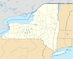

Kennung: Fl W 6s (rot zwischen 87° und 203° Bauzeit: 1833 Betriebszeit: 1893–heute Internationale Ordnungsnummer: USCG = 1-35395 ARLHS = USA-565
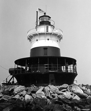
Old Orchard Shoal Light ist ein Leuchtturm in der Lower New York Bay, mit dem eine Untiefe markiert wird. Das Bauwerk wurde am 25. April 1893 in Betrieb genommen.[1] Am 20. September 2006 wurde das Bauwerk in das National Register of Historic Places aufgenommen.[2] Außerdem wird das Old Orchard Shoal Light auch im Maritime Heritage Program des National Park Service als sehenswerter Leuchtturm geführt [3][4].
Der 1893 gebaute Leuchtturm liegt etwa 5,5 km südlich vom New Dorp Beach am Gedney Channel in der Lower New York Bay auf einem 0,72 Acre großen Grundstück, das von der Flut überspült wird. Der Turm ist eine 35 Fuß (10,5 m) hohe Konstruktion aus Gusseisen, die im Innern auf drei Etagen die etwa 90 qm große Wohnung des Leuchtturmwärters beinhaltet. Im Innern sind die Wände bis in den dritten Stock mit Backsteinen kaschiert.[5] Die Fresnel-Linse wurde 1950 entfernt.
Frank Schubert, der der letzte zivile Leuchtturmwärter in den Vereinigten Staaten gewesen sein soll, war hier stationiert, bevor er auf Governors Island und schließlich zum Coney Island Light versetzt wurde.
Am 29. Mai 2007 entschied das Secretary of the Interior, dass die Old Orchard Shoal Light Station Ausschuss gemäß dem National Historic Lighthouse Preservation Act von 2000 sei.
Es fand sich keine Gruppe, die bereit und in der Lage dazu war, das Bauwerk nach dem National Historic Lighthouse Preservation Act zu erhalten. Deswegen bot die General Services Administration das Old Orchard Shoal Light ab Juni 2008 zum Verkauf durch eine Auktion an. Es wurde am 27. August 2008 für 235.000 US-Dollar zugeschlagen.[6]
Belege
- ↑ Annual report of the Light-House Board to the Secretary of the Treasury for the Fiscal Year ended June 30, 1893, Treasury Department, Document No 1647
- ↑ National Register Information System. National Register of Historic Places. National Park Service. Abgerufen am 13. März 2009.
- ↑ National Park Service's Maritime Heritage Program's Inventory of Historic Light Stations
- ↑ National Park Service's Maritime Heritage Program's Inventory of NY Historic Light Stations
- ↑ Available properties through the National Historic Lighthouse Preservation Program for 2007
- ↑ GSA listing (1-PR-08-005): Old Orchard Shoal
Kategorien:- Erbaut in den 1890er Jahren
- Leuchtturm in den Vereinigten Staaten
- Denkmal im National Register of Historic Places (New York)
- Bauwerk in Staten Island

Wikimedia Foundation.