- Olentangy River
-
Olentangy River 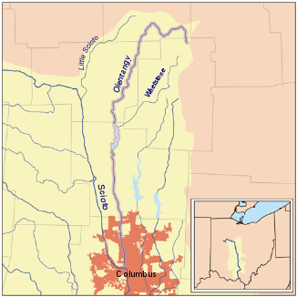
Olentangy River innerhalb des Einzugsbebiets des Scioto Rivers
Daten Gewässerkennzahl US: 1066873 Lage Nördliches zentrales Ohio, USA Flusssystem Mississippi River Abfluss über Scioto River → Ohio River → Mississippi River → Golf von Mexiko Ursprung 3,2 km nordöstlich von Galion, Ohio
40° 42′ 0″ N, 82° 43′ 36″ W40.7000589-82.72656665363Quellhöhe 363 m[1] Mündung Scioto River bei Columbus, Ohio 39.9658976-83.0165727216Koordinaten: 39° 57′ 57″ N, 83° 1′ 0″ W
39° 57′ 57″ N, 83° 1′ 0″ W39.9658976-83.0165727216Mündungshöhe 216 m[1] Höhenunterschied 147 m Länge 142 km[2] Einzugsgebiet 8.737 km²[2] Durchflossene Stauseen Delaware Lake Großstädte Columbus  Olentangy River in Columbus
Der Olentangy River ist der größte linke Nebenfluss des Scioto River im US-Bundesstaat Ohio. Seine Quelle liegt im Crawford County rund 3,2 km nordöstlich der Stadt Galion. Er fließt zunächst in westlicher Richtung, biegt östlich der Gemeinde Bucyrus nach Süden, fließt durch den Delaware Lake und erreicht nach etwa 90 km den Campus der Ohio State University, bevor er in der Innenstadt von Columbus in den Scioto River mündet.[3]
Der Olentangy River hieß ursprünglich Whetstone River, wurde 1833 jedoch infolge eines Gesetzes umbenannt, nach dem die alten indianischen Flussbezeichnungen eingeführt werden sollten. Das Wort Olentangy bedeutet in der Sprache der Delaware Fluss der roten Gesichtsbemalung. Der Fluss dient als Trinkwasserreservoir für die Bewohner des Delaware County. Ein Abschnitt von etwa 35 km des Olentary River wurde vom Ohio Department of Natural Resources mit dem Prädikat State Scenic River ausgezeichnet und unter besonderen Schutz gestellt.
Am Oberlauf des Olentangy Rivers fand während des Crawford-Feldzugs im Juni 1782 ein Gefecht zwischen den Truppen Crawfords gegen Indianer und mit ihnen verbündete Briten statt. In der Schlacht am Olentangy wurden drei Amerikaner getötet und acht verwundet; die vermutlich weit höheren Verluste der Indianer und Briten sind unbekannt.[4]
Einzelnachweise
- ↑ a b Google Earth Höhenlage für GNIS-Koordinaten, abgerufen am 25. Juli 2010.
- ↑ a b Einzugsgebiet des Olentangy
- ↑ Olentangy. Abgerufen am 25. Juli 2010.
- ↑ Crawford’s Expedition against Sandusky
Weblinks
Kategorien:- Flusssystem Ohio River
- Fluss in Ohio
- Fluss in Nordamerika


Wikimedia Foundation.