Røyken

Røyken
Wappen Karte
Wappen der Kommune Røyken
Røyken (Norwegen)
Røyken
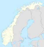
Røyken
Basisdaten
Kommunennummer: 0627 (auf Statistik Norwegen)
Provinz (fylke): Buskerud
Verwaltungssitz: Midtbygda
Koordinaten: 59° 44′ N, 10° 25′ O59.74027777777810.4125Koordinaten: 59° 44′ N, 10° 25′ O
Fläche: 113 km²
Einwohner:

19.290 (1. Jan. 2011)[1]

Bevölkerungsdichte: 171 Einwohner je km²
Sprachform: Bokmål
Webpräsenz:
Politik
Bürgermeister: Rune Kjølstad (H) (1999)
Lage in der Provinz Buskerud
Lage der Kommune in der Provinz Buskerud

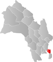
Røyken ist eine Kommune in der Provinz (Fylke) Buskerud in Norwegen. Hurum hat 19.290 Einwohner (Stand: 1. Januar 2011) und erstreckt sich über eine Fläche von 113 km². Verwaltungssitz ist Midtbygda.

Weblinks

 Commons: Røyken – Album mit Bildern und/oder Videos und Audiodateien

Einzelnachweise

  1. Statistics Norway – Berekna folkemengd 1. januar 2011 og berekna folketilvekst i 2010. Fylke og kommunar

Wikimedia Foundation.

Игры ⚽ Поможем написать курсовую

Schlagen Sie auch in anderen Wörterbüchern nach:

  • Røyken — Blason de Røyken Localisation de Røyken dans le Buskerud …   Wikipédia en Français

  • Røyken — Infobox Kommune name=Røyken idnumber=0627 county=Buskerud landscape= capital=Røyken governor=Rune Kjølstad (H) governor as of=2003 arearank=378 area=113 arealand=111 areapercent=0.03 population as of=2004 populationrank=59 population=17,082… …   Wikipedia

  • Royken — Admin ASC 2 Code Orig. name Røyken Country and Admin Code NO.04.0627 NO …   World countries Adminstrative division ASC I-II

  • Røyken Station — Infobox Norwegian station name = Røyken caption = locale = Røyken municipality = Røyken line = Spikkestadbanen distance = 33.63 km elevation = coordinates = start = 1872 architect = platforms = 1 owner = Jernbaneverket operator = Norges… …   Wikipedia

  • Royken — Original name in latin Ryken Name in other language State code NO Continent/City Europe/Oslo longitude 59.74743 latitude 10.39521 altitude 113 Population 2775 Date 2013 05 24 …   Cities with a population over 1000 database

  • Åsåker Station — Coordinates: 59°44′28.11″N 10°21′52.03″E / 59.7411417°N 10.3644528°E / 59.7411417; 10.3644528 …   Wikipedia

  • IL ROS — Infobox athletics club clubname = IL ROS fullname = Idrettslaget Røyken og Spikkestad founded = 6 November 1919 20 March 1963 (merger) ground = Spikkestad stadion Spikkestad Idrettslaget Røyken og Spikkestad is a Norwegian sports club from Røyken …   Wikipedia

  • Рёйкен — норв. Røyken   коммуна Норвегии   …   Википедия

  • List of schools in Norway — Schools in Norway are usually divided into the following categories: elementary schools ( barneskole ) 1st to 7th grade, lower secondary schools ( ungdomsskole ) 8th to 10th grade, upper secondary schools ( videregående skole ) 11th to 13th grade …   Wikipedia

  • Hallenskog Station — Infobox Norwegian station name = Hallenskog caption = locale = Hallenskog municipality = Røyken line = Spikkestadbanen distance = 30.88 km elevation = 100.9 m coordinates = start = 1933 architect = platforms = 1 owner = operator = Norges… …   Wikipedia

Share the article and excerpts

Direct link
Do a right-click on the link above
and select “Copy Link”