- Sačurov
-
Sačurov
Wappen Karte 
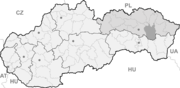

Sačurov BasisdatenKraj: Prešovský kraj Okres: Vranov nad Topľou Region: Horný Zemplín Fläche: 21,18 km² Einwohner: 2.214 (31. Dez. 2010) Bevölkerungsdichte: 104,53 Einwohner je km² Höhe: 129 m n.m. Postleitzahl: 094 13 Telefonvorwahl: 0 57 Geographische Lage: 48° 49′ N, 21° 42′ O48.82166666666721.694722222222129Koordinaten: 48° 49′ 18″ N, 21° 41′ 41″ O Kfz-Kennzeichen: VT Gemeindekennziffer: 529125 StrukturGemeindeart: Gemeinde VerwaltungBürgermeister: Peter Barát Adresse: Obecný úrad Sačurov
Osloboditeľov 385
09414 SačurovWebpräsenz: www.sacurov.sk/ Gemeindeinformation
auf portal.gov.skStatistikinformation
auf statistics.skSačurov (ungarisch Szacsúr) ist eine Gemeinde in der Ostslowakei.
Inhaltsverzeichnis
Geografie
Die Gemeinde liegt an der Topľa, kurz vor deren Mündung in die Ondava, etwa 40 Kilometer nordöstlich von Košice. Westlich der Gemeinde erhebt sich der Gebirgszug Slanské vrchy mit dem Strechový vrch (777 Meter über dem Meer). Das flache Relief um Sačurov gehört zum Ostslowakischen Tiefland. Die Stadt Vranov nad Topľou liegt etwa sechs Kilometer nördlich von Sačurov.
Bevölkerung
In der Gemeinde Sačurov leben fast ausschließlich Slowaken. 65% der Einwohner bekennen sich zur Römisch-katholischen Kirche. 32% sind Griechisch-katholische Christen.[1]
Geschichte
Der Ort wurde im Jahr 1399 erstmals urkundlich erwähnt. Bis 1882 war der seitdem zu Sedliská gehörende Ort Podčičva (damals ungarisch Csicsvaalja) ein Teil der Gemeinde.
Sehenswürdigkeiten
- Römisch-katholische Kirche aus dem Jahr 1769 in spätbarockem Stil
- Griechisch-katholische Kirche aus dem Jahr 1709
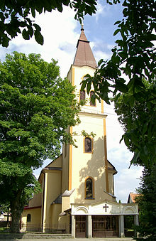 Römisch-katholische Kirche
Verkehrsanbindung
Sačurov liegt an der Fernstraße I/79, die von Vranov nad Topľou über Trebišov zum Grenzübergang Slovenské Nové Mesto/Sátoraljaújhely führt und die Teil der Transitstraße von Südostpolen nach Ungarn ist.
Persönlichkeiten
- Štefan Kasarda (1935-2006), in Sačurov geborener Schriftsteller und Dramaturg
Quellen
- ↑ Zahlen des Statistikportales MOŠ desJahres 2001. Abgerufen am 30. April 2011 (slowakisch).
Gemeinden im Okres Vranov nad TopľouBabie | Banské | Benkovce | Bystré | Cabov | Čaklov | Čičava | Čierne nad Topľou | Davidov | Detrík | Dlhé Klčovo | Ďapalovce | Ďurďoš | Giglovce | Girovce | Hanušovce nad Topľou | Hencovce | Hermanovce nad Topľou (Hermannsdorf) | Hlinné | Holčíkovce | Jasenovce | Jastrabie nad Topľou | Juskova Voľa | Kamenná Poruba | Kladzany | Komárany | Kučín | Kvakovce | Majerovce | Malá Domaša | Matiaška | Medzianky | Merník | Michalok (Michalok) | Nižný Hrabovec | Nižný Hrušov | Nižný Kručov | Nová Kelča | Ondavské Matiašovce | Pavlovce | Petkovce | Petrovce | Piskorovce | Poša | Prosačov | Radvanovce | Rafajovce | Remeniny | Rudlov | Ruská Voľa | Sačurov | Sečovská Polianka | Sedliská | Skrabské | Slovenská Kajňa | Soľ | Štefanovce | Tovarné | Tovarnianska Polianka | Vavrinec | Vechec | Vlača | Vranov nad Topľou (Frönel an der Töpl) | Vyšný Kazimír | Vyšný Žipov | Zámutov | Zlatník | Žalobín
Wikimedia Foundation.
Schlagen Sie auch in anderen Wörterbüchern nach:
Sačurov — (Village) Administration Pays Slovaquie … Wikipédia en Français
Sačurov — is a village and municipality in Vranov nad Topľou District in the Prešov Region of eastern Slovakia.HistoryIn historical records the village was first mentioned in 1402.GeographyThe municipality lies at an altitude of 129 metres and covers an… … Wikipedia
Sedliská — Wappen Karte … Deutsch Wikipedia
Prešov Region — Geobox | Region name = Prešov category = Region image caption = image caption = symbol = symbol type = etymology = official name = motto = nickname = country = Slovakia country state = region = district = commune = municipality = border = part… … Wikipedia
Vranov nad Topľou District — Infobox Slovak district subject name = Vranov nad Topľou District region district slovak region = Prešov Region population = 76,504 (2001) prefix = ? area = 769 car plate = VT image location = Okres vranov.png Vranov nad Topľou District ( okres… … Wikipedia
Nižný Hrabovec — Location of Vranov nad Topľou District in the Nižný Hrabovec (Hungarian: Alsógyertyán; earlier i.a.: Slovak Nižssí Hrabowec/Hungarian Alsóhrabóc) is a village and municipality in the Vranov nad Topľou District in the Prešov Region of Slovakia … Wikipedia
List of municipalities and towns in Slovakia — Slovakia This is a comprehensive list of municipalities and towns in Slovakia. For lists of towns and municipalities sorted by Regions see the individual articles on Regions. For an outdated list of towns only in Slovakia see also List of towns… … Wikipedia
Davidov (municipality) — Location of Vranov nad Topľou District Davidov is a village and municipality in the Vranov nad Topľou District in the Prešov Region of Slovakia … Wikipedia
Čičava — Location of Vranov nad Topľou District in the Prešov Region. Čičava is a village and municipality in Vranov nad Topľou District in the Prešov Region of eastern Slovakia. History In historical records t … Wikipedia
Čierne nad Topľou — Location of Vranov nad Topľou District in the Prešov Region. Čierne nad Topľou is a village and municipality in Vranov nad Topľou District in the Prešov Region of eastern Slovakia. History In historical re … Wikipedia
Sačurov

18+
© Academic, 2000-2026
- Kontaktieren Sie uns: Unterstützung, Werbung
Wörterbücher Export, schritte mit PHP, Joomla, Drupal, WordPress, MODx.