- Sagavanirktok River
-
Sagavanirktok River 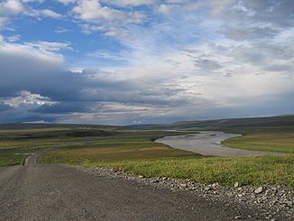
Sagavanirktok River und Dalton Highway
Daten Lage Alaska Quellgebiet Brookskette
68° 9′ 48″ N, 148° 55′ 53″ W68.163333-148.931389Mündung Beaufortsee bei Prudhoe Bay 70.320833-148.036111Koordinaten: 70° 19′ 15″ N, 148° 2′ 10″ W
70° 19′ 15″ N, 148° 2′ 10″ W70.320833-148.036111Länge 298 km Der Sagavanirktok River ist ein 298 km langer Fluss in der North Slope von Alaska. Er entspringt an der Nordflanke der Brookskette zwischen den Endicott und den Philip Smith Mountains und mündet bei Prudhoe Bay in die Beaufortsee.
Zwischen Atigun Pass und Deadhorse verlaufen der Dalton Highway und die Trans-Alaska-Pipeline über weite Strecken parallel zum Sagavanirktok River.
Die Bezeichnung der Eskimos für den Fluss wurde 1901 von S. J. Marsh, einem Prospektor, als „Sawanukto“ aufgezeichnet, was so viel wie „starke Strömung“ bedeutet.
Weblinks

Wikimedia Foundation.