- Sandy Bay (Devon)
-
Sandy Bay 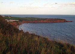
Blick über die Sandy Bay zum Straight Point
Gewässer Ärmelkanal Landmasse Großbritannien (Insel) Geographische Lage 50° 36′ 27″ N, 3° 22′ 3″ W50.60747-3.3674Koordinaten: 50° 36′ 27″ N, 3° 22′ 3″ W 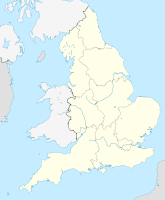

Breite ca. 1 km Die Sandy Bay ist eine abgelegene Bucht mit Sandstrand von circa zwei Kilometern Länge und befindet sich nahe Exmouth, in der Grafschaft Devon, an der Ärmelkanalküste von England. Die Bucht ist von hohen Klippen umgeben und Teil eines langen Sandstreifen, der bei Ebbe mit den Strand von Exmouth verbunden ist.
Lage
Sandy Bay liegt circa sechzehn Kilometer südlich der Stadt Exeter, vier Kilometer südöstlich von Exmouth und etwa elf Kilometer südwestlich von Sidmouth.
Das Badeort Sandy Bay ist für die riesigen Devon Cliffs bekannt. Westlich von Sandy Bay sind die Orcombe Felsen, sehr berühmt für seine Fossilien. Die Landzunge im Osten wird Straight Point genannt und wird von den Marines als Schießplatz genutzt. Weiter östlich befinden sich Otter Cove, Littleton Cove und der Kiesstrand von Budleigh Salterton.
Geologie
Die roten Felsen an der Steilküste bei Sandy Bay sind zumeist aus Schichten von „Aylesbeare Mudstone“ und stammen aus der Zeit vor 250.000.000 Jahren. Die Klippen bestehen überwiegend aus diversen Mudstone-Schichten, aber zugleich auch Schichten aus Sandstein. Beide Sedimente sind markant rot, was bezeugt, dass sie in einer Wüste gebildet wurden. Das Meerwasser färbt sich bei stürmischem Wellengang rot.
Die Küste und die Klippen entlang Ost Devon und Dorset am Ärmelkanal gehören zu den Naturwundern der Welt. Von Orcombe Point, bei Exmouth, bis zu Old Harry Rocks, östlich von Studland Bay, erstreckt sich ein 155 Kilometer langer Küstenstreifen, der als erste Naturlandschaft in England von der UNESCO zum Weltnaturerbe erklärt wurde[1]. Die Steilküste und der Sandstrand von Sandy Bay sind Teil der sogenannten Jurassic Coast.
Orcombe Point ist durch eine Geo-Nadel gekennzeichnet und zeigt den Ausgangspunkt für die World Heritage Tour. Die Steinschichten entlang der Jurassic Coast sind leicht nach Osten gekippt. Deswegen wird der älteste Teil der Küste in diesem Bereich gefunden, progressiv jüngere Gesteine bilden die Klippen weiter östlich.
- siehe auch Liste der Orte entlang der Jurassic Coast
Einzelnachweise
- ↑ Dorset and East Devon Coast. UNESCO World Heritage Centre (2001). Abgerufen am 19. Oktober 2010.
Kategorien:- Devon
- Bucht (Ärmelkanal)
- Bucht in England
- Bucht in Europa
- Jurassic Coast
- Weltnaturerbe (Europa)


Wikimedia Foundation.