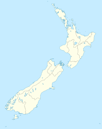
Waipapa (Northland)

Waipapa (Northland)

p1

Waipapa
Waipapa (Neuseeland)
Waipapa
Koordinaten 35° 12′ S, 173° 55′ O-35.206636111111173.91735Koordinaten: 35° 12′ S, 173° 55′ O
Region Northland
Distrikt Far North District

Waipapa (Māori:Fluss am flachen Land[1]) ist ein kleiner Ort in der Bay of Islands im Far North District der Region Northland auf der Nordinsel Neuseelands. Er liegt am State Highway 10, etwa 3 km nordwestlich vom nächsten größeren Ort, Kerikeri.[2] Waipapa hat weder einen Supermarkt noch eine Schule, so dass viele Einwohner täglich nach Kerikeri fahren.

Die meisten Unternehmen in Waipapa liegen am Highway, darunter eine Filiale des Discounters Warehouse in der Klinac Lane. Die ortsansässigen Māori gehören zum Iwi Ngāpuhi.

Waipapa liegt im Landesinneren und hat keinen Strand, jedoch eine Anlegestelle südlich der Mündung des Waipapa Stream in den Kerikeri Inlet. In der Nähe befindet sich der Stone Store von Kerikeri. Südlich von Waipapa verläuft der Kerikeri River mit den Rainbow Falls.

Einzelnachweise

  1. Das Neuseelandbuch, NZ Visitor Publications Ltd., Nelson 2003 S. 115 ISBN 1-877339-00-8
  2. New Zealand Travel Atlas, Wise Maps Auckland ISBN 0-908794-47-9

Weblinks


Wikimedia Foundation.

Игры ⚽ Поможем решить контрольную работу

Schlagen Sie auch in anderen Wörterbüchern nach:

  • Waipapa — bezeichnet in Neuseeland einen Ort in der Region Northland, siehe Waipapa (Northland) einen Ort in der Region Waikato, siehe Waipapa (Waikato) einen Ort in der Region Marlborough, siehe Waipapa Bay einen Fluss, siehe Waipapa River D …   Deutsch Wikipedia

  • Waipapa River (Northland) — Waipapa RiverVorlage:Infobox Fluss/GKZ fehlt Lage Region Northland, Nordinsel (Neuseeland) Flusssystem Hokianga Vorlage:Infobox Fluss/ABFLUSSWEG fehlt …   Deutsch Wikipedia

  • Waipapa — is a small township in the Bay of Islands, of Northland New Zealand. It is around 10 minutes drive from Kerikeri,the nearest urban centre to Waipapa, located on State Highway 10. Waipapa its self is so small, having no supermarket or school, that …   Wikipedia

  • Waipapa (canoe) — Infobox waka waka name =Waipapa (canoe) commander = priest = departed = landed =Doubtless Bay iwi = settled =NorthlandIn Māori tradition, Waipapa was one of the great ocean going, voyaging canoes that was used in the migrations that settled New… …   Wikipedia

  • Geology of New Zealand — The continent of Zealandia The geology of New Zealand is noted for its volcanic activity, earthquakes and geothermal areas because of its position on the boundary of the Australian Plate and Pacific Plates. New Zealand was earlier part of the… …   Wikipedia

  • List of dual place names in New Zealand — The agreed dual name of Te Koko o Kupe / Cloudy Bay remembers both the Māori and British explorations of New Zealand. Many official place names in New Zealand are dual names, incorporating both the original Māori place names and the English names …   Wikipedia

  • Mangapa River — Mouth Waipapa River Basin countries New Zealand Length 10 kilometres (6.2 mi) The Mangapa River is a river of the far north of New Zealand s North Island. It flows south from its sources in the Omahuta Forest to reach the Waipapa River 25… …   Wikipedia

  • The Catlins — (sometimes referred to as The Catlins Coast) comprises an area in the southeastern corner of the South Island of New Zealand. The area lies between Balclutha and Invercargill, straddling the boundary between the Otago and Southland regions. It… …   Wikipedia

  • Mataatua — Great Māori migration waka Commander Toroa Iwi Ngāi Tūhoe, Ngāti Awa, Te Whakatōhea, Te Whānau ā Apanui, Ngā Puhi, Ngāi Te Rangi, Ngāti Pūkenga In Māori tradition, Mataatua was one of the great voyag …   Wikipedia

  • The Catlins — Localización de The Catlins en la Isla Sur de Nueva Zelanda. Localización País: Nueva Zelanda Isla: Isla Sur …   Wikipedia Español

Share the article and excerpts

Direct link
Do a right-click on the link above
and select “Copy Link”