- Yayladağı
-
Yayladağı 
Hilfe zu Wappen

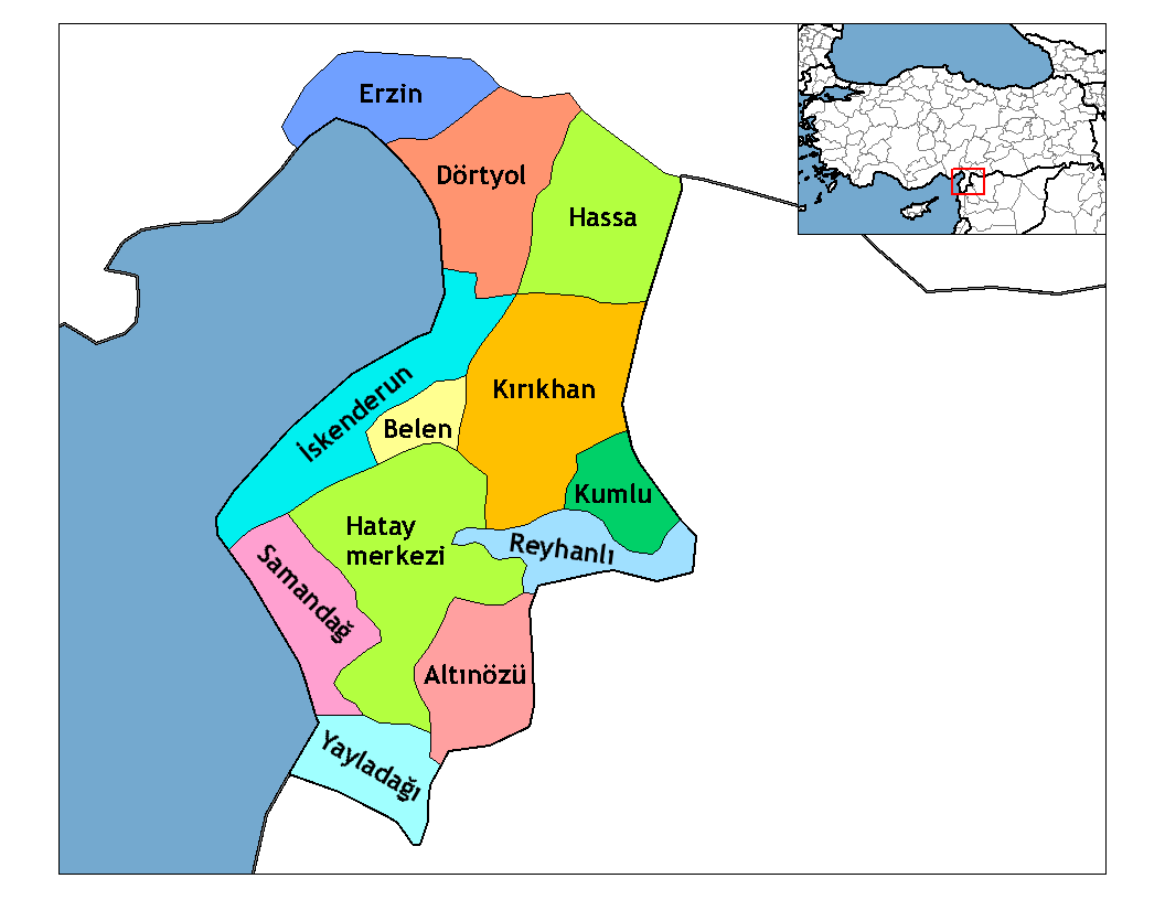
Basisdaten Provinz (il): Hatay Koordinaten: 35° 54′ N, 36° 4′ O35.902536.060555555556415Koordinaten: 35° 54′ 9″ N, 36° 3′ 38″ O Höhe: 415 m Einwohner: 6.471[1] (2010) Telefonvorwahl: (+90) 326 Postleitzahl: 31550 Kfz-Kennzeichen: 31 Struktur und Verwaltung (Stand: 2011) Bürgermeister: Mustafa Kemal Dağıstanlı (MHP) Webpräsenz: Landkreis Yayladağı Einwohner: 22.529[1] (2010) Fläche: 366 km² Bevölkerungsdichte: 62 Einwohner je km² Kaymakam: Tolga Polat Webpräsenz (Kaymakam): Yayladağı (früher Ordu) ist eine Kreisstadt in der türkischen Provinz Hatay. Gleichzeitig ist Yayladağı Hauptort des gleichnamigen Landkreises. Yayladağı liegt an der südlichen Spitze am Mittelmeer. Der Landkreis bildet den südlichsten Teil der Türkei und grenzt an Syrien (Gouvernements Idlib und Latakia). Hier gibt es einen Grenzübergang namens Yayladağı Gümrük Kapısı. Die Stadt hat 6.471 und der Landkreis 22.529 Einwohner (Stand 2010).
Einzelnachweise
- ↑ a b Türkisches Institut für Statistik, abgerufen am 22. Mai 2011
Weblinks
-
 Commons: Yayladağı – Sammlung von Bildern und/oder Videos und Audiodateien
Schlagen Sie auch in anderen Wörterbüchern nach:
Yayladağı — Administration Pays … Wikipédia en Français
Yayladağı — Infobox Settlement settlement type = District subdivision type = Country subdivision name = TUR timezone=EET utc offset=+2 map caption =Location of PAGENAME within Turkey. timezone DST=EEST utc offset DST=+3official name = Yayladağı image caption … Wikipedia
Yayladagi — Original name in latin Yaylada Name in other language Ordu, Yayladagi, Yaylada Yayladgi, Yayladi State code TR Continent/City Europe/Istanbul longitude 35.9025 latitude 36.06272 altitude 421 Population 8308 Date 2012 01 18 … Cities with a population over 1000 database
Yayladagi Ilcesi — Admin ASC 2 Code Orig. name Yayladağı İlçesi Country and Admin Code TR.31.438427 TR … World countries Adminstrative division ASC I-II
Yayladağı — is., öz. Hatay iline bağlı ilçelerden biri … Çağatay Osmanlı Sözlük
Hatay Province — Infobox Province TR name=Hatay region=Mediterranean area=5,403 total population= 1,386,224 licence = 31 area code= 326| Hatay is a province of southern Turkey, on the Mediterranean coast, with Syria to the south and east.Geography46% of the land… … Wikipedia
Mehmet Aksoy — Born 1939 (age 71–72) Kesap, Yayladağı, Hatay Province, Turkey Nationality Turkish Field Sculpture … Wikipedia
Extreme points of Turkey — The extreme points of Turkey are:*Northernmost: Tavşan Island situated 1 km from İnceburun(Cape İnce), by Sinop(42 5 53 N, 34 56 33 E) *Southernmost: The spring of Kale Stream, Yayladağı, Hatay Province(35 48 46 N, 36 9 8 E) *Westernmost: Cape… … Wikipedia
Яйладагы — Город Яйладагы тур. Yayladağı Страна ТурцияТурция … Википедия
Çukurova — This article is about a region in Turkey. For the district municipality in Adana, see Çukurova, Adana. Çukurova Region Location of Çukurova within Turkey … Wikipedia
Yayladağı


18+
© Academic, 2000-2026
- Kontaktieren Sie uns: Unterstützung, Werbung
Wörterbücher Export, schritte mit PHP, Joomla, Drupal, WordPress, MODx.