- Pennine Bridleway
-
Der Pennine Bridleway ist ein neuer National Trail in Nordengland.
Er läuft ungefähr parallel zum Pennine Way und ermöglicht die Nutzung für Reiter, Radfahrer und Fußgänger. In seinem südlichen Teil, folgt er dem High Peak Trail entlang dem Gleisbett der ehemaligen Cromford and High Peak Railway. Der Weg ist rund 209 km (130 Meilen) lang, 117 km (73 Meilen) von Derbyshire bis zu den südlichen Pennines plus der 76 km (47 Meilen) lange Mary-Towneley-Rundweg und der 16 km (10 Meilen) lange Settle-Rundweg.[1] Die höchsten Punkte entlang der Strecke sind South Head Hill in Derbyshire (zwischen Rushup Edge und Hayfield) und Top of Leach, dem höchsten Punkt auf dem Mary-Towneley-Rundweg.
Wegverlauf
Der Pennine Bridleway beginnt in Middleton-by-Wirksworth, Derbyshire, hauptsächlich auf historischen Routen und Wegen entlang der Flanken der Pennines. Er folgt zunächst dem High Peak Trail auf einer stillgelegten Bahnstrecke, die durch den Kalkstein des White Peaks führt. (Ein alternative Ausgangspunkt ist das Gelände des ehemaligen Hartington Bahnhofs über einen kurzen Abschnitt des Tissington Trail, bevor dieser in Parsley Hay auf den High Peak Trail stößt. Hinter dem Kalkplateau ist der Milestone Grit des Dark oder High Peak Gebiets, von wo der Weg einer Packesel-Straße von Tideswell über Peak Forest nach Hayfield folgt, wo er kurz auf der ehemaligen Bahnlinie einer anderen stillgelegten Eisenbahn entlanführt, dem Sett Valley Trail.
Sobald er Derbyshire Richtung Greater Manchester verlässt, folgt den Spuren der Kante eines Heidekraut Moor und einer alten Fernstraße entlang dem Tame Tal. Von hier führt der Weg hinab zu einer stillgelegegten Eisenbahn, von wo die Strecke in Richtung des Hollingworth Sees führt. Später folgt der Mary-Towneley-Rundweg, der zum höchsten Punkt des Trails ansteigt: Zum Leach mit 474 Metern (1.555 ft). Der Weg führt durch die Stadt Waterfoot im Rossendale-Tal und folgt einer neuen Route über Lumb, der Cliviger Schlucht und den Long Causeway. Der Weg folgt dann der Gorple Road, einem abgelegenen Teil des Weges, der zum Blackshaw Head führt. Der Weg führt dann ins Calder-Tal und durch die Stadt Hebden Bridge, wo die Strecke über die London Road in Richtung Bottomley führt.
Einzelnachweise
National Trails in England und Wales
Cleveland Way | Cotswold Way | Glyndŵr’s Way | Hadrian’s Wall Path | North Downs Way | Offa’s Dyke Path | Peddar’s Way | Pembrokeshire Coast Path | Pennine Bridleway | Pennine Way | The Ridgeway | South Downs Way | South West Coast Path | Thames Path | Yorkshire Wolds WayLong Distance Routes in Schottland
Great Glen Way | Southern Upland Way | Speyside Way | West Highland Way
Wikimedia Foundation.
Schlagen Sie auch in anderen Wörterbüchern nach:
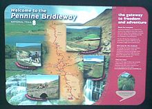
Pennine Bridleway — Infobox Hiking trail Name=Pennine Bridleway Photo=Pennine bridleway information board.jpg Caption=Information board at Hartington station Location=Northern England, United Kingdom Designation=UK National Trail Length=convert|130|mi|km|abbr=on… … Wikipedia
Pennine Way — in der Nähe von Marsden Daten Länge 429 km Lage Nordengland … Deutsch Wikipedia
Pennine Way — Infobox Hiking trail Name=Pennine Way Photo=Pennine scenery.jpg Caption=View from the Pennine Way, near Marsden Location=Northern England, United Kingdom Designation=UK National Trail Length=429 km (268 mi) Start/End Points=Edale, Derbyshire Kirk … Wikipedia
Pennine Cycleway — The Pennine Cycleway is a Sustrans sponsored route from the English city of Derby to Berwick upon Tweed on the Scottish border. It is part of the National Cycle Network (NCN 68) and was opened in 2003. It has a total length of about 355 miles,… … Wikipedia
National Trails — This article is about the official UK network of long distance walking and riding routes . For National Trails of the United States, see National Trails System. National Trail redirects here. For other uses, see National Trail (disambiguation).… … Wikipedia
National Trails (United Kingdom) — National Trails is an umbrella agency of the UK government which has a mandate to promote, maintain and develop the network of long distance footpaths in England and Wales. National Trails is funded by Natural England and the Countryside Council… … Wikipedia
Tissington Trail — MetaSidebar|26%|#eeffff|right|Access points on the route Parsley Hay (where it joins High Peak Trail) Hartington station Ruby Wood Alsop en le Dale Tissington Thorpe (for Dovedale) Narlows Lane Mapleton Lane (Ashbourne) The Tissington Trail is a… … Wikipedia
High Peak Trail — The High Peak Trail is a convert|17|mi|adj=on trail for walkers, cyclists and horse riders in the Peak District, England. Running from Dowlow, near Buxton, to High Peak Junction, Cromford, it follows the trackbed of the former Cromford and High… … Wikipedia
Hayfield — infobox UK place official name = Hayfield static static image caption=Hayfield from the north west os grid reference = population = country = England region = East Midlands shire county = Derbyshire shire district = High Peak latitude = 53.38… … Wikipedia
Hail Storm Hill — The Pennine Bridleway just to the north of the summit Elevation 477 m (1,565 ft) … Wikipedia


