Cowarts (Alabama)

Cowarts (Alabama)
Cowarts
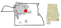
Lage in Alabama
Basisdaten
Staat: Vereinigte Staaten
Bundesstaat: Alabama
County: Houston County
Koordinaten: 31° 12′ N, 85° 18′ W31.199444444444-85.3063888888897Koordinaten: 31° 12′ N, 85° 18′ W
Zeitzone: Central Standard Time (UTC−6)
Einwohner: 1604 (Stand: 2006)
Bevölkerungsdichte: 85,8 Einwohner je km²
Fläche: 18,7 km²
davon 18,7 km² Land
Höhe: 106 m
Postleitzahl: 36321
Vorwahl: +1 334
FIPS: 01-18088
GNIS-ID: 0116756

Cowarts ist ein Ort im Houston County, Alabama, USA. Die Gesamtfläche des Ortes beträgt 18,8 km².

Politik

Am 9. November 2007 ertrank der 71jährige Bürgermeister Henry Ellis Johnston von Cowarts nach einem Schlaganfall im Olympia Spa in Dothan[1].

Demographie

Nach einer Schätzung aus dem Jahr 2006 hatte Cowarts 1604 Einwohner, die sich auf 603 Haushalte und 469 Familien verteilten. Die Bevölkerungsdichte betrug somit 84,7 Einwohner/km². 84,93% der Bevölkerung waren weiß, 12,35% afroamerikanisch. In 32,3% der Haushalte lebten Kinder unter 18 Jahren. Das Durchschnittseinkommen eines Haushaltes betrug 36688 Dollar, wobei 13,1% der Bevölkerung unterhalb der Armutsgrenze lebten.

Quellen

  1. Cowarts Mayor Drowns at Dothan Spa

Wikimedia Foundation.

Игры ⚽ Нужна курсовая?

Schlagen Sie auch in anderen Wörterbüchern nach:

  • Cowarts, Alabama —   Town   Location in …   Wikipedia

  • Alabama locations by per capita income — Alabama has the thirty eighth highest per capita income in the United States of America, at $18,189 (2000). Its personal per capita income is $26,338 (2003), the fortieth highest in the country. Its median household income is $34,135 (2000),… …   Wikipedia

  • Cowarts — Lage in Alabama …   Deutsch Wikipedia

  • Cowarts — Cowarts, AL U.S. town in Alabama Population (2000): 1546 Housing Units (2000): 684 Land area (2000): 7.236943 sq. miles (18.743595 sq. km) Water area (2000): 0.012684 sq. miles (0.032851 sq. km) Total area (2000): 7.249627 sq. miles (18.776446 sq …   StarDict's U.S. Gazetteer Places

  • Cowarts, AL — U.S. town in Alabama Population (2000): 1546 Housing Units (2000): 684 Land area (2000): 7.236943 sq. miles (18.743595 sq. km) Water area (2000): 0.012684 sq. miles (0.032851 sq. km) Total area (2000): 7.249627 sq. miles (18.776446 sq. km) FIPS… …   StarDict's U.S. Gazetteer Places

  • Liste der wichtigsten Städte in Alabama — Abbeville Abel Abernant Ada Adamsville Addison Adger Akron Alabama Port Alabaster Alberta Albertville Alexander City Alexandria Aliceville Allgood Alma Alpine Alton Altoona Andalusia Anderson Annemanie …   Deutsch Wikipedia

  • Houston County, Alabama — Verwaltung US Bundesstaat: Alabama Verwaltungssitz: Dothan Adresse des Verwaltungssitzes: County Courthouse P.O. Box 6406 Dothan, AL 36302 6406 Gründung …   Deutsch Wikipedia

  • Dothan, Alabama — Dothan   City   Downtown Dothan, Alabama, looking up Foster St. Nickname(s) …   Wikipedia

  • Condado de Houston (Alabama) — Para otros usos de este término, véase Condado de Houston. Condado de Houston Condado de los Estados Unidos …   Wikipedia Español

  • Houston County (Alabama) — Houston County Courthouse in Dothan, gelistet im NRHP Nr. 74000412[1] Verwaltung US …   Deutsch Wikipedia

Share the article and excerpts

Direct link
Do a right-click on the link above
and select “Copy Link”