- Datu Abdullah Sangki
-
Municipality of Datu Abdullah Sangki Lage von Datu Abdullah Sangki in der Provinz Maguindanao 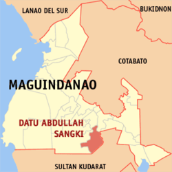
Basisdaten Bezirk: Autonomous Region in Muslim Mindanao Provinz: Maguindanao Barangays: 10 Distrikt: 2. Distrikt von Maguindanao PSGC: 153828000 Einkommensklasse: unbekannt (1-6) Haushalte: Zensus 1. Mai 2000Einwohnerzahl: 33.259 Zensus 1. August 2007Koordinaten: 6° 50′ N, 124° 30′ O6.8311124.5072Koordinaten: 6° 50′ N, 124° 30′ O Geographische Lage auf den Philippinen 

Datu Abdullah Sangki Datu Abdullah Sangki ist eine philippinische Stadtgemeinde in der Provinz Maguindanao.
Datu Abdullah Sangki wurde durch den Muslim Mindanao Autonomy Act Nr. 153 vom 20. August 2003, welcher am 3. Januar 2004 in einer Volksabstimmung ratifiziert wurde, gegründet[1]. Muttergemeinde ist die Stadtgemeinde Ampatuan, zu der die zehn Baranggays Datu Abdullah Sangkis zuvor gehörten.
Baranggays
Datu Abdullah Sangki ist politisch in zehn Baranggays unterteilt.
- Banaba
- Dimampao
- Guinibon
- Kaya-kaya
- Maganoy
- Mao
- Maranding
- Sugadol
- Talisawa
- Tukanolocong (Tukanologong)
Einzelnachweise
- ↑ National Statistical Coordination Board (22. August 2004): 2004 Factsheet (January to July 2004). Abgerufen am 24. Juni 2006.
Städte und Stadtgemeinden in der Provinz MaguindanaoStädte: Cotabato City
Stadtgemeinden: Ampatuan | Buluan | Datu Abdullah Sangki | Datu Anggal Midtimbang | Datu Paglas | Datu Piang | Datu Saudi-Ampatuan | Datu Unsay | Gen. S. K. Pendatun | Guindulungan | Mamasapano | Mangudadatu | Pagagawan | Pagalungan | Paglat | Pandag | Rajah Buayan | Shariff Aguak | South Upi | Sultan sa Barongis | Talayan | Talitay
Wikimedia Foundation.
Schlagen Sie auch in anderen Wörterbüchern nach:
Datu Abdullah Sangki — Saltar a navegación, búsqueda Datu Abdullah Sangki es un municipio filipino de la provincia de Maguindanao. El municipio fue creado bajo el Muslim Mindanao Autonomy Act No. 153 de 20 de agosto de 2003, ratificado a través de plebiscito el 3 de… … Wikipedia Español
Datu Abdullah Sangki, Maguindanao — Map of Maguindanao showing the location of Datu Abdullah Sangki Country Philippines … Wikipedia
Datu Piang, Maguindanao — Datu Piang Seal … Wikipedia
Datu Saudi-Ampatuan, Maguindanao — Datu Saudi biruar Ampatuan, Maguindanao Map of Maguindanao showing the location of Datu Saudi Ampatuan Country Philippines … Wikipedia
Datu Paglas, Maguindanao — Map of Maguindanao showing the location of Datu Paglas Coordinates … Wikipedia
Datu Unsay, Maguindanao — Map of Maguindanao showing the location of Datu Unsay Country Philippines Region … Wikipedia
Datu Anggal Midtimbang, Maguindanao — Country Philippines Region Autonomous Region in Muslim Mindanao Province Maguindanao Districts Lone district of Maguindanao … Wikipedia
Datu Hoffer Ampatuan, Maguindanao — Datu Hoffer Ampatuan is a municipality in the province of Maguindanao, Philippines. According to the 2007 census, it has a population of at least 22,471 people (not counting the population of barangays only partially included). It was created out … Wikipedia
Datu Salibo, Maguindanao — Datu Salibo is a municipality in the province of Maguindanao, Philippines. According to the 2007 census, it has a population of at least 13,876 people (not counting the population of barangays only partially included). It was created out of 4… … Wikipedia
Datu Anggal Midtimbang — Municipality of Datu Anggal Midtimbang Lage von Datu Anggal Midtimbang in der Provinz Maguindanao Basisdaten Bezirk … Deutsch Wikipedia
Datu Abdullah Sangki


18+
© Academic, 2000-2026
- Kontaktieren Sie uns: Unterstützung, Werbung
Wörterbücher Export, schritte mit PHP, Joomla, Drupal, WordPress, MODx.