- Pagagawan
-
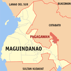
Municipality of Pagagawan Lage von Pagagawan in der Provinz Maguindanao Basisdaten Bezirk: Autonomous Region in Muslim Mindanao Provinz: Maguindanao Barangays: 11 Distrikt: 2. Distrikt von Maguindanao PSGC: 153822000 Einkommensklasse: unbekannt (1-6) Haushalte: 5466 Zensus 1. Mai 2000Einwohnerzahl: 32.995 Zensus 1. August 2007Koordinaten: 7° 6′ N, 124° 46′ O7.1124.76666666667Koordinaten: 7° 6′ N, 124° 46′ O Offizielle Webpräsenz: www.pagagawan.gov.ph Geographische Lage auf den Philippinen Pagagawan ist eine philippinische Stadtgemeinde in der Provinz Maguindanao. Nach dem Zensus vom 1. Mai 2000 hat sie 27.010 Einwohner in 5466 Haushalten.
Baranggays
Pagagawan ist politisch in elf Baranggays unterteilt.
- Balatungkayo (Batungkayo)
- Bulit
- Bulod
- Dungguan
- Limbalud
- Maridagao
- Nabundas
- Pagagawan
- Talapas
- Talitay
- Tunggol
Städte und Stadtgemeinden in der Provinz MaguindanaoStädte: Cotabato City
Stadtgemeinden: Ampatuan | Buluan | Datu Abdullah Sangki | Datu Anggal Midtimbang | Datu Paglas | Datu Piang | Datu Saudi-Ampatuan | Datu Unsay | Gen. S. K. Pendatun | Guindulungan | Mamasapano | Mangudadatu | Pagagawan | Pagalungan | Paglat | Pandag | Rajah Buayan | Shariff Aguak | South Upi | Sultan sa Barongis | Talayan | Talitay
Wikimedia Foundation.
Schlagen Sie auch in anderen Wörterbüchern nach:
Datu Montawal, Maguindanao — Datu Montawal (formerly Pagagawan) is a 1st class municipality in the province of Maguindanao, Philippines. According to the 2000 census, it has a population of 27,010 people in 5,466 households. Barangays Datu Montawal is politically subdivided… … Wikipedia
Cotabato (Stadt) — Cotabato City Lage von Cotabato innerhalb der Provinz Maguindanao Basisdaten Bezirk: SOCCSKSARGEN … Deutsch Wikipedia
Maganoy — Municipality of Shariff Aguak (Maganoy) Lage von Shariff Aguak in der Provinz Maguindanao Basisdaten Bezirk: Autonomous Region in Muslim … Deutsch Wikipedia
PH-MAG — Lage der Provinz Maguindanao (vor 2006) Maguindanao ist eine Provinz der Philippinen, die sich in der Zentralregion der Insel Mindanao befindet. Die Provinz gehört politisch zum Bezirk ARMM (Autonomous Region in Muslim Mindanao). Die Hauptstadt… … Deutsch Wikipedia
Geography of the Philippines — Country geography name = the Philippines continent = Asia region = Southeast Asia coordinates = 13°00 N 122°00 E area ranking = 72nd km area = 300000 percent land = 99.38 km coastline = 36289 borders = None northernmost point = Y Ami island… … Wikipedia
Maguindanao — redirects here. For other uses, see Maguindanao (disambiguation). Maguindanao Province … Wikipedia
List of cities and municipalities in the Philippines — This is a list of cities and municipalities in the Philippines arranged by province and in alphabetical order. As of 2006, there are 118 cities and 1509 municipalities.As of September 4, 2007, there are 136 cities, 1,495 municipalities, 81… … Wikipedia
Quadripoint — In geography, a quadripoint is a point on the Earth that touches four distinct regions. Such points are often called four corners , from the corners of the four regions meeting there. [One could argue that, if one region lies on one side of a… … Wikipedia
Legislative district of Maguindanao — The lone Legislative District of Maguindanao, is the representation of the Province of Maguindanao. Maguindanao was part of the representation of Region XII from 1978 to 1984. It first was first granted its own representations in the Regular… … Wikipedia
Ampatuan — Municipality of Ampatuan Lage von Ampatuan in der Provinz Maguindanao Basisdaten Bezirk … Deutsch Wikipedia