Addlestone

Addlestone
Addlestone
Koordinaten 51° 22′ N, 0° 29′ W51.3695-0.49010000000001Koordinaten: 51° 22′ N, 0° 29′ W
Addlestone (England)
Addlestone
Addlestone
Bevölkerung 16.657
Verwaltung
Post town Weybridge
Postleitzahlen­abschnitt KT15
Vorwahl 01932
Landesteil England
Region South East England
Shire county Surrey
District Runnymede
Civil parish Addlestone
Britisches Parlament Runnymede and Weybridge

Addlestone ist eine Stadt in der Grafschaft Surrey im Süden Englands.

Naheliegende Gemeinden sind Weybridge, Ottershaw, Chertsey, New Haw sowie Walton-on-Thames. Addlestone hat derzeit etwa 16 657 Einwohner.

Die Stadt befindet sich in der Nähe des Motorway M25.

Die Stadt wird in H. G. Wells’ Buch Krieg der Welten erwähnt.

Söhne und Töchter der Stadt

Weblinks

 Commons: Addlestone – Sammlung von Bildern, Videos und Audiodateien
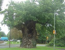
Alte Eiche in Addlestone

Wikimedia Foundation.

Игры ⚽ Поможем написать реферат

Schlagen Sie auch in anderen Wörterbüchern nach:

  • Addlestone — infobox UK place country = England official name= Addlestone map type= Surrey latitude= 51.3695 longitude= 0.4901 population = 16,657 shire district= Runnymede shire county = Surrey region= South East England constituency westminster= Runnymede… …   Wikipedia

  • Addlestone — Original name in latin Addlestone Name in other language Addlestone State code GB Continent/City Europe/London longitude 51.37135 latitude 0.49353 altitude 19 Population 14978 Date 2011 02 14 …   Cities with a population over 1000 database

  • Addlestone — This most interesting surname is of Anglo Saxon origin, and derives from an Olde English pre 7th Century personal name, Aethelstan , composed of the elements aethel , noble and stan , stone; hence noble stone . Variants of the surname in the… …   Surnames reference

  • Addlestone & Weybridge Town F.C. — Addlestone Weybridge Town F.C. was a football club based in Addlestone, England. They changed their name from Addlestone. in 1980. They reached the Quarter Finals of the FA Vase twice in their history. However in 1985, they stopped their… …   Wikipedia

  • Addlestone railway station — Infobox UK station name = Addlestone code = ASN manager = South West Trains locale = Addlestone borough = Runnymede start = 14 February 1848 platforms = 2 usage0405 = 0.213 usage0506 = 0.238 usage0607 = 0.286Addlestone railway station serves the… …   Wikipedia

  • River Bourne, Addlestone — River Addlestone Bourne should not be confused with the River Bourne, Chertsey. The River Bourne flows through Addlestone, Surrey with its source at West End, near Chobham. At St George s College, Surrey the River Addlestone Bourne joins with the …   Wikipedia

  • New Haw — Coordinates: 51°21′29″N 0°29′20″W / 51.358°N 0.4888°W / 51.358; 0.4888 …   Wikipedia

  • Liste von Automobilmarken — Automobilmarken, kurz Automarken, sind die Handelsnamen, unter denen Automobil Hersteller Fahrzeuge vertreiben. Aufgelistet werden Hersteller von Pkw und Rennwagen, die Automobile gebaut haben, bauen oder bauen wollten. Nutzfahrzeuge werden in… …   Deutsch Wikipedia

  • Air Navigation and Engineering Company — L Air Navigation and Engineering Company était un constructeur d avions britanniques. Elle a été créée en 1919 à cessé ses activités en 1927. Sommaire 1 Historique 2 Avions construits 3 Automobile construite 4 R …   Wikipédia en Français

  • Weybridge — infobox UK place country = England latitude=51.37204 longitude= 0.45270 official name= Weybridge map type= Surrey population = 19,463 shire district= Elmbridge shire county = Surrey region= South East England constituency westminster= Runnymede… …   Wikipedia

Share the article and excerpts

Direct link
Do a right-click on the link above
and select “Copy Link”