Detroit River

Detroit River
Detroit River
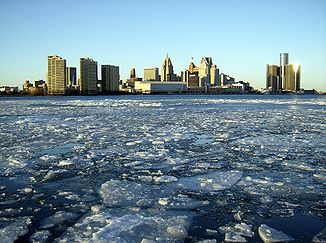
Der Detroit River im Winter

Der Detroit River im WinterVorlage:Infobox Fluss/KARTE_fehlt

DatenVorlage:Infobox Fluss/GKZ_fehlt
Lage Grenze Michigan, USA/Ontario, Kanada
Flusssystem Niagara RiverSankt-Lorenz-StromVorlage:Infobox Fluss/FLUSSSYSTEM_falsch

Vorlage:Infobox Fluss/ABFLUSSWEG_fehlt

Ursprung Lake St. Clair
42° 21′ 17″ N, 82° 55′ 35″ W42.35476-82.9263037175
Quellhöhe 175 mVorlage:Infobox Fluss/HÖHENBEZUG-QUELLE_fehltVorlage:Infobox Fluss/NACHWEISE_fehlen
Mündung in den Eriesee
42.041155-83.1496467174

42° 2′ 28″ N, 83° 8′ 59″ W42.041155-83.1496467174
Mündungshöhe 174 mVorlage:Infobox Fluss/HÖHENBEZUG-MÜNDUNG fehltVorlage:Infobox Fluss/NACHWEISE_fehlen
Höhenunterschied 1 m
Länge 51 kmVorlage:Infobox Fluss/NACHWEISE_fehlenVorlage:Infobox Fluss/EINZUGSGEBIET_fehlt

Vorlage:Infobox Fluss/ABFLUSS_fehlt

Großstädte Detroit

Der Detroit River ist ein ungefähr 51 Kilometer langer und bis zu vier Kilometer breiter Fluss im US-Bundesstaat Michigan und in der kanadischen Provinz Ontario. Der Name kommt aus dem französischen Rivière du Détroit, wobei das Wort Détroit eine Meerenge bezeichnet.

Der Fluss verbindet den Lake St. Clair mit dem Eriesee. Er bildet zudem die Grenze zwischen den USA und Kanada. Im Fluss liegen viele Inseln. Die drei größten sind Grosse Ile, Fighting Island und Belle Isle.

Der Detroit River liefert das Trinkwasser für über fünf Millionen Menschen.

Weblinks


Wikimedia Foundation.

Игры ⚽ Поможем решить контрольную работу

Schlagen Sie auch in anderen Wörterbüchern nach:

  • Detroit-River — (D. Street), der Theil des St. Lorenzstromes, welcher den St. Clair See mit dem Erie See (in Nordamerika) verbindet, 6 Ml. lang …   Pierer's Universal-Lexikon

  • Detroit River — Detroit River, Teilstrecke des St. Lorenzstroms (s.d.) zwischen St. Clair und Eriesee, 35 km lang und durch Ausbaggerung 5,5 m tief, mit einem jährlichen Durchgangsverkehr von gegen 40 Mill. Ton …   Meyers Großes Konversations-Lexikon

  • Detroit River — Coordinates: 42°03′06″N 83°09′05″W / 42.05167°N 83.15139°W / 42.05167; 83.15139 …   Wikipedia

  • Detroit River International Wildlife Refuge — IUCN Category Ib (Wilderness Area) North Maumee Bay Archeological District …   Wikipedia

  • Detroit River Light — Undated U.S.C.G. photo Location Lake Erie south of Detroit River Year first constructed 1875 (lightship) 1885 (current tower) Automated 1979 Foundation …   Wikipedia

  • Detroit River — River, southeastern Michigan, U.S. Forming part of the boundary between Michigan and Ontario, Can. , it connects Lake St. Clair with Lake Erie. It flows south for 32 mi (51 km) past Detroit and Windsor, Ont., where a bridge and tunnel connect the …   Universalium

  • Detroit River International Crossing — The Detroit River International Crossing (DRIC), alternatively New International Trade Crossing (NITC), is a multi national construction project and committee between Canada and the United States to create a new border crossing over the Detroit… …   Wikipedia

  • Detroit River Heritage Parkway — The Detroit River Heritage Parkway is a tourist route in Essex County, Ontario, stretching from Windsor to Amherstburg. The designation was given by the Essex Region Conservation Authority, and placed along roads that travel closely to the… …   Wikipedia

  • Detroit River International Wildlife Refuge — Sp Detròito Ùpės tarptautinis gamtõs rezervãtas Ap Detroit River International Wildlife Refuge L JAV (Mičigano v ja) …   Pasaulio vietovardžiai. Internetinė duomenų bazė

  • Detroit River — noun a short river flowing from Lake St. Clair to Lake Erie along the border between the United States and Canada; one the busiest inland waterways in the world • Instance Hypernyms: ↑river • Part Holonyms: ↑Michigan, ↑Wolverine State, ↑Great… …   Useful english dictionary

Share the article and excerpts

Direct link
Do a right-click on the link above
and select “Copy Link”