- Erewash
-
Borough of Erewash 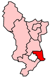
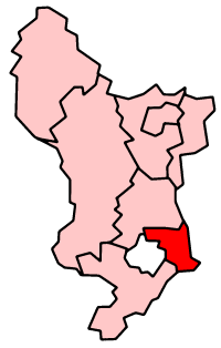
Lage in DerbyshireStatus Borough Region East Midlands Verw.grafschaft Derbyshire Verwaltungssitz Ilkeston Fläche 109,63 km² (235.) Einwohner 110.700 (198.) ONS-Code 17UG Website www.erewash.gov.uk Erewash ist ein Verwaltungsbezirk mit dem Status eines Borough in der Grafschaft Derbyshire in England. Verwaltungssitz ist die Stadt Ilkeston; weitere bedeutende Orte sind Long Eaton, Ockbrook and Borrowash, Sandiacre und West Hallam.
Der Bezirk wurde am 1. April 1974 gebildet und entstand aus der Fusion des Borough of Ilkeston, des Urban District Long Eaton und eines Teils des Rural District South East Derbyshire.
Amber Valley | Bolsover | Chesterfield | Derbyshire Dales | Erewash | High Peak | North East Derbyshire | South Derbyshire
Wikimedia Foundation.
Schlagen Sie auch in anderen Wörterbüchern nach:
Erewash — Infobox UK district name = Borough of Erewash status = Borough region = East Midlands admincounty = Derbyshire area = Ranked 235th 109.63 km² adminhq = Ilkeston onscode = 17UG population = Ranked English district rank|ONS=17UG English district… … Wikipedia
Erewash — ▪ district, England, United Kingdom borough (district), administrative and historic county of Derbyshire, England. Its eastern boundary is the River Erewash, from which the borough takes its name. It is bounded on the south by the Rivers… … Universalium
Erewash Valley Line — MetaSidebar|19%|#eeffff|right|Stations and landmarks Trent Junction Trent station * Long Eaton * Langley Mill Alfreton Tunnel Alfreton Chesterfield * closed The Erewash Valley Line runs from south of Chesterfield along the Erewash Valley to Trent … Wikipedia
Erewash Canal — The Erewash Canal is a broad canal in Derbyshire, England. It runs just under 12 miles (19 km) and has 14 locks. The first lock at Langley Bridge is actually part of the Cromford Canal. Origins The canal obtained its act of parliament in 1777… … Wikipedia
Erewash (UK Parliament constituency) — UK constituency infobox Name = Erewash Map1 = Erewash Map2 = Derbyshire Type = County Year = 1983 Entity = Derbyshire County = Derbyshire EP = East Midlands MP = Liz Blackman Party = LabourErewash is a county constituency represented in the House … Wikipedia
Erewash Valley — The Erewash Valley is the valley of the River Erewash (pronounced erry wash ) on the border of Derbyshire and Nottinghamshire as far as the River Trent. It runs along the boundary of the southern end of the Derbyshire hills and the more rolling… … Wikipedia
River Erewash — The River Erewash is a river in England that flows roughly southwards through Derbyshire, close to its eastern border with Nottinghamshire. Overview It rises at a point south east of Kirkby in Ashfield, flows roughly westward to Eastwood then… … Wikipedia
Derby and Sandiacre Canal Trust — The Derby and Sandiacre Canal Trust is a waterway society, a charitable trust no. 1042227[1], registered November 21, 1994, and a registered company No. 2956417, operating in Derbyshire and Nottingham, England, UK. The Society s aim is the… … Wikipedia
Nutbrook Canal — Parts of the canal still have water in 2006 Original owner Nutbrook Canal Proprietors Principal engineer Benjamin Outram … Wikipedia
Cromford Canal — The end of the canal, in Cromford Original owner Cromford Canal Company Principal engineer Benjamin Outram … Wikipedia
Erewash
18+
© Academic, 2000-2026
- Kontaktieren Sie uns: Unterstützung, Werbung
Wörterbücher Export, schritte mit PHP, Joomla, Drupal, WordPress, MODx.