- Derbyshire Dales
-
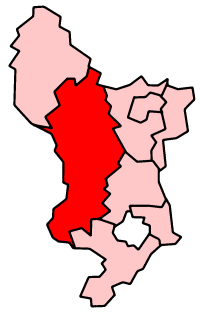
Derbyshire Dales District 
Lage in DerbyshireStatus District Region East Midlands Verw.grafschaft Derbyshire Verwaltungssitz Matlock Fläche 795,36 km² (46.) Einwohner 70.200 (316.) ONS-Code 17UF Website www.derbyshiredales.gov.uk Derbyshire Dales ist ein District in der Grafschaft Derbyshire in England. Der größte Teil liegt im Peak-District-Nationalpark, die Bevölkerung lebt hauptsächlich entlang des Flusses Derwent. Verwaltungssitz ist die Stadt Matlock; weitere bedeutende Orte sind Ashbourne, Bakewell, Baslow, Darley Dale, Eyam, Hathersage, Tideswell und Wirksworth.
Der Bezirk wurde am 1. April 1974 gebildet und entstand aus der Fusion der Urban Districts Ashbourne, Bakewell, Matlock und Wirksworth sowie der Rural Districts Ashbourne und Bakewell. Die Bezeichnung lautete zunächst West Derbyshire, wurde später aber in Derbyshire Dales geändert.
Amber Valley | Bolsover | Chesterfield | Derbyshire Dales | Erewash | High Peak | North East Derbyshire | South Derbyshire
Wikimedia Foundation.
Schlagen Sie auch in anderen Wörterbüchern nach:
Derbyshire Dales — For the Parliamentary constituency, see Derbyshire Dales (UK Parliament constituency). Derbyshire Dales District District … Wikipedia
Derbyshire Dales (UK Parliament constituency) — Derbyshire Dales County constituency for the House of Commons Boundary of Derbyshire Dales in Derbyshire for the 2010 general elect … Wikipedia
Derbyshire Dales local elections — Derbyshire Dales District Council in Derbyshire, England is elected every four years. Contents 1 Political control 2 Council elections 3 By election results 3.1 … Wikipedia
Derbyshire Dales National Nature Reserve — The Derbyshire Dales National Nature Reserve is a series of unconnected limestone dales in the Peak District National Park. It is managed by Natural England and has a permanent staff of wardens who carry out conservation works and ensure the… … Wikipedia
Derbyshire Dales Narrow Gauge Railway — [v · d · … Wikipedia
Derbyshire Dales — ▪ district, England, United Kingdom district, administrative and historic county of Derbyshire, England. About half of the district lies within the scenic Peak District National Park. The Romans mined lead in the area between… … Universalium
Osmaston, Derbyshire Dales — Not to be confused with Osmaston, Derby. Coordinates: 52°59′N 1°42′W / 52.99°N 1.70°W / 52.99; 1.70 … Wikipedia
Pilsley, Derbyshire Dales — Infobox UK place country = England static static image caption=Pilsley cottages latitude = 53.235 longitude = 1.641 map type = Derbyshire official name = Pilsley population = shire district = Derbyshire Dales shire county = Derbyshire region =… … Wikipedia
Derbyshire Constabulary — Logo of the Derbyshire Constabulary. Agency overview … Wikipedia
Derbyshire — Geografie Status: Zeremonielle und Verwaltungsgrafschaft Region: East Midlands Fläche … Deutsch Wikipedia
Derbyshire Dales
18+
© Academic, 2000-2026
- Kontaktieren Sie uns: Unterstützung, Werbung
Wörterbücher Export, schritte mit PHP, Joomla, Drupal, WordPress, MODx.