- Erikub
-
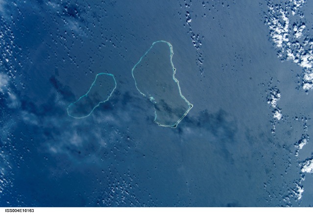
Erikub NASA-Bild von Erikub (links, Mitte Wotje)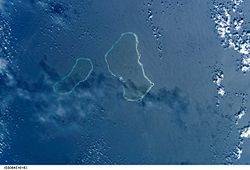
Gewässer Pazifischer Ozean Archipel Marshallinseln Geographische Lage 9° 9′ N, 170° 0′ O9.1416666666667170Koordinaten: 9° 9′ N, 170° 0′ O 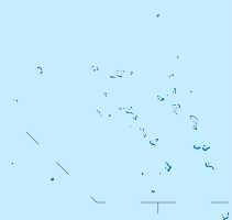

Anzahl der Inseln 16 Hauptinsel --- Landfläche 1,53 km² Lagunenfläche 230 km² Einwohner (unbewohnt) Erikub oder auch Ãdkup ist ein unbewohntes Atoll der Ratak-Kette der Marshallinseln. Das Atoll hat eine Landfläche von 1,53 km², die eine Lagune von 230 km² umschließt. Das Atoll liegt nur 3 km vom benachbarten Atoll Wotje entfernt. Die höchste Erhebung des Atolls liegt 9 m über dem Meeresspiegel. Auf dem Eiland wachsen Kokospalmen.
Weblinks
 Atolle und Einzel-Inseln der Marshallinseln
Ratak-Kette: Ailuk | Arno-Atoll | Aur | Bikar | Bokak | Erikub | Knox-Atoll | Likiep | Majuro-Atoll | Maloelap | Mili | Toke | Utirik | Wotje
Keinem Atoll zugehörige Inseln: Jemo | Mejit
Ralik-Kette: Ailinginae | Ailinglapalap | Bikini-Atoll | Ebon-Atoll | Eniwetok | Jaluit | Kwajalein | Lae-Atoll | Namorik | Namu | Rongdrik | Rongelap-Atoll | Ujae | Ujelang | Wotho
Keinem Atoll zugehörige Inseln: Jabwot | Kili | Lib
Wikimedia Foundation.
Schlagen Sie auch in anderen Wörterbüchern nach:
Erikub — Saltar a navegación, búsqueda Imagen satelital de el Atolón Erikub (el atolón mas pequeño que aparece en la imagen), tomada por la NASA. El Atolón Erikub es un atolón localizado en el área central de la Cadena de Ratak en las Islas Marshall. El… … Wikipedia Español
Erikub — 09°08′30″N 170°00′00″E / 9.14167, 170 Erikub est un atoll des Marshall. Erikub est composé de 6 îlots formant un t … Wikipédia en Français
Erikub Atoll — The Erikub Atoll is an atoll located in the central area of the Ratak Chain in the Marshall Islands. The atoll lies slightly south of a slightly larger atoll called Wotje. There are 6 islands which combine to create a total land area of 1.53 km² … Wikipedia
Erikub Atoll — Admin ASC 1 Code Orig. name Erikub Atoll Country and Admin Code MH.100 MH … World countries Adminstrative division ASC I-II
MH-WTJ — Wotje NASA Bild von Wotje (Mitte, links Erikub) Gewässer Pazifischer Ozean Archipel … Deutsch Wikipedia
MH-L — Ratak Kette Karte der Marshallinseln, im Osten die Ratak Kette Gewässer Pazifischer Ozean Anzahl der Inseln 16 … Deutsch Wikipedia
Wotje — Vorlage:Infobox Insel/Wartung/Höhe fehlt Wotje NASA Bild von Wotje (Mitte, links Erikub) Gewässer Pazifischer Ozean … Deutsch Wikipedia
Marshall Islands — Republic of the Marshall Islands Aolepān Aorōkin M̧ajeļ[1][2] … Wikipedia
Ailinglaplap — NASA Bild von Ailinglaplap Gewässer Pazifischer Ozean Archipel … Deutsch Wikipedia
Aur-Atoll — Aur NASA Bild von Aur (links), in der Mitte Maloelap Gewässer Pazifischer Ozean … Deutsch Wikipedia
Erikub

18+
© Academic, 2000-2026
- Kontaktieren Sie uns: Unterstützung, Werbung
Wörterbücher Export, schritte mit PHP, Joomla, Drupal, WordPress, MODx.