- Goblin Valley State Park
-
Der Goblin Valley State Park ist ein Staatspark im Südosten Utahs in der Nähe von Hanksville an der Utah State Route 24. Der Park wurde am 24. August 1964 gegründet und hat eine Fläche von 12,2 km². Es gibt ein Besucherzentrum und einen Campingplatz.
Inhaltsverzeichnis
Geschichte
Cowboys auf der Suche nach Rindern entdeckten zunächst dieses Tal, bevor Ende der 1920er Jahre Arthur Chaffin mit zwei Begleitern auf der Suche nach einer alternativen Verbindungsstrecke zwischen Green River und Caineville auf dieses Tal stießen. Chaffin war so beeindruckt, dass er 1949 für mehrere Tage in das von ihm "Pilztal" (Mushroom Valley) genannte Gebiet zurückkehrte und die Formationen untersuchte und fotografierte.
Geologie
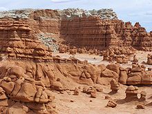
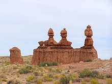
Wind, Wasser und Erosion haben im Laufe von Millionen Jahren aus dem Sandstein des Tales Figuren geformt, welche an versteinerte Pilze oder Kobolde erinnern – daher der Name Goblin Valley, Koboldtal.
Flora und Fauna
Die Vegetation ist begrenzt auf Pflanzen, welche sich dem heißen, trockenem Wüstenklima und dem wehenden Sand angepasst haben. Beispiele sind Mormon Tea (Ephedra viridis), Russische Distel (Salsola collina), Indian Ricegrass (Oryzopsis hymenoides) und verschiedene Kakteen.
Die meisten Tiere sind nachtaktiv. Es kommen u. a. Kaninchen, Skorpione, Klapperschlangen und Kojoten vor.
Medien
- Für die Science-Fiction-Parodie Galaxy Quest – Planlos durchs Weltall war das Goblin Valley Drehort bei den Szenen mit dem Steinmonster.
- Die US-amerikanische Rockband The Killers drehte das Video für ihren Song «Human» im Goblin Valley.
Weblinks
- Website des Parks (englisch)
- Reportage über das Goblin Valley
- Infosammlung über den Goblin Valley SP bei USA-TI
- Bildergalerie bei USA-TI
- Goblin Valley State Park im Geographic Names Information System des United States Geological Survey
Anasazi Indian | Antelope Island | Bear Lake | Camp Floyd | Coral Pink Sand Dunes | Dead Horse Point | Deer Creek | East Canyon | Edge Of the Cedars | Escalante | Fremont Indian | Goblin Valley | Goosenecks | Green River | Großer Salzsee | Gunlock | Historic Union Pacific Rail Trail | Huntington | Hyrum | Iron Mission | Jordanelle | Kodachrome | Millsite | Otter Creek | Palisade | Piute | Quail Creek | Red Fleet | Rockport | Sand Hollow | Scofield | Snow Canyon | Starvation | Steinaker | Utah Territorial Statehouse | Utahsee | Wasatch Mountain | Willard Bay | Yuba Lake
Wikimedia Foundation.


