Isehara (Kanagawa)

Isehara (Kanagawa)
伊勢原市
Isehara-shi
Isehara (Japan)
DEC
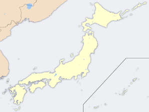
Geographische Lage in Japan
Region: Kantō
Präfektur: Kanagawa
Koordinaten: 35° 24′ N, 139° 19′ O35.403055555556139.3157Koordinaten: 35° 24′ 11″ N, 139° 18′ 54″ O
Basisdaten
Fläche: 55,52 km²
Einwohner: 100.620
(1. Mai 2008)
Bevölkerungsdichte: 1.812 Einwohner je km²
Gemeindeschlüssel: 14214-0
Symbole
Wappen:
Wappen von Isehara
Baum: Shii-Castanopsis
Blume: Ballonblume
Vogel: Kupferfasan
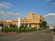
Rathaus
Adresse: Isehara City Hall
348 Tanaka
Isehara-shi
Kanagawa 259-1188
Webadresse:
Lage Iseharas in der Präfektur Kanagawa
Lage Iseharas in der Präfektur

Isehara (jap. 伊勢原市, -shi) ist eine Stadt im Zentrum der Präfektur Kanagawa.

Inhaltsverzeichnis

Geographie

Isehara liegt südlich von Tokio, westlich von Yokohama und Atsugi, nördlich von Hiratsuka und östlich von Hadano.

Geschichte

Isehara erhielt am 1. März 1971 das Stadtrecht.

Verkehr

Söhne und Töchter der Stadt

Angrenzende Städte und Gemeinden

Weblinks

Rathaus von Isehara

Wikimedia Foundation.

Игры ⚽ Поможем написать реферат

Schlagen Sie auch in anderen Wörterbüchern nach:

  • Isehara, Kanagawa — Infobox City Japan Name= Isehara JapaneseName= 伊勢原市 Map Region= Kantō Prefecture= Kanagawa District= Area km2= 55.52 PopDate= May 2008 Population= 100,620 Density km2= 1812 Coords= LatitudeDegrees= 35 LatitudeMinutes= 23 LatitudeSeconds=… …   Wikipedia

  • Isehara — shi 伊勢原市 Geographische Lage in Japan …   Deutsch Wikipedia

  • Isehara Station — (伊勢原駅) is a railway station in Isehara, Kanagawa, Japan. Lines*Odakyu Electric Railway **Odakyu Odawara LineBuildingThe station has two island platforms and four tracks.Platforms###@@@KEYEND@@@### …   Wikipedia

  • Isehara — shi (伊勢原市) Temple bouddhiste Hinata Yakushi Administration Pays Japon Région Kantō Préfe …   Wikipédia en Français

  • Kanagawa Prefectural Board of Education — (神奈川県教育委員会) is the board of education of the Kanagawa Prefecture, Japan.The board consists of six members; one of them is elected as the chair (教育委員長), and one of them is appointed by the board as the superintendent (教育長).The board administers to …   Wikipedia

  • Kanagawa — Préfecture de Kanagawa Préfecture de Kanagawa · 神奈川県 Kanagawa ken Carte du Japon avec la Préfecture de Kanagawa mise en évidence. Pays  Japon …   Wikipédia en Français

  • Kanagawa Prefecture — Infobox Prefecture Japan Name = Kanagawa JapaneseName = 神奈川県 Rōmaji = Kanagawa ken Symbol = PrefSymbol Kanagawa.png Capital = Yokohama Region = Kantō Island = Honshū TotalArea = 2,415.42 AreaRank = 43rd PCWater = 2.3 PopDate = September 1, 2007… …   Wikipedia

  • Prefectura de Kanagawa — Kanagawa 神奈川県 Kanagawa ken Prefectura de Japón …   Wikipedia Español

  • Naka District, Kanagawa — Map of Naka District with Meiji period area in yellow, modern area in green; 1= Ōiso Town; 2=Ninomiya Town Naka District (中郡, Naka gun?) is an administrative …   Wikipedia

  • Atsugi (Kanagawa) — 厚木市 Atsugi shi Geographische Lage in Japan …   Deutsch Wikipedia

Share the article and excerpts

Direct link
Do a right-click on the link above
and select “Copy Link”