- Amphoe Don Phut
-
Don Phut
ดอนพุดProvinz: Saraburi Fläche: 58,714 km² Einwohner: 6.957 (2000) Bev.dichte: 118,5 E./km² PLZ: 18210 Geocode: 1907 Karte 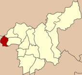
Amphoe Don Phut (in Thai: อำเภอ ดอนพุด) ist ein Landkreis (Amphoe - Verwaltungs-Distrikt) im Westen der Provinz Saraburi. Die Provinz Saraburi liegt in der Zentralregion von Thailand.
Inhaltsverzeichnis
Geographie
Benachbarte Distrikte (von Norden im Uhrzeigersinn): Amphoe Mueang Lopburi der Provinz Lopburi, Amphoe Nong Don und Amphoe Ban Mo der Provinz Saraburi, Amphoe Tha Ruea, Amphoe Nakhon Luang, Amphoe Maha Rat und Amphoe Ban Phraek der Provinz Ayutthaya.
Geschichte
Am 31. Mai 1971 wurde der Landkreis Don Phut zunächst als Unterbezirk (King Amphoe) eingerichtet, indem die Tambon Don Phut, Dong Ta Ngao, Ban Luang und Phai Lio vom Amphoe Ban Mo abgetrennt wurden.[1] Am 4. November 1993 bekam er offiziell den vollen Amphoe-Status. [2]
Die meisten Einwohner dieses Bezirks sind Thai Phuan (Thai: ไทยพวน), die während der Regierungszeit von König Phra Phuttaloetla (Rama II.) aus dem Amphoe Chiang Khong, aus Luang Prabang und Vientiane hier eingewandert waren.
Verwaltung
Amphoe Don Phut ist in vier Kommunen (Tambon) eingeteilt, die sich weiter in 28 Dörfer (Mubaan) unterteilen.
Don Phut selbst hat einen Kleinstadt-Status (Thesaban Tambon) und besteht aus allen Tambon des Kreises ausgenommen Dong Ta Ngau. Dong Ta Ngau wird von einer „Tambon Administrative Organization“ (TAO, องค์การบริหารส่วนตำบล - Verwaltungs-Organisation) verwaltet.
Nr. Name Thai Dörfer Einw. 1. Don Phut ดอนพุด 5 1.615 2. Phai Lio ไผ่หลิ่ว 7 1.352 3. Ban Luang บ้านหลวง 7 1.701 4. Dong Ta Ngao ดงตะงาว 9 2.034 Einzelnachweise
- ↑ ประกาศกระทรวงมหาดไทย เรื่อง แบ่งท้องที่ตั้งเป็นกิ่งอำเภอ Royal Gazette Ban 88, Ausg. 59 ง spezial (ฉบับพิเศษ) vom 4. Juni 1971, S. 12 (in Thai)
- ↑ พระราชกฤษฎีกาตั้งอำเภอลำทับ อำเภอร่องคำ อำเภอเวียงแหง อำเภอนาโยง อำเภอแก้งสนามนาง อำเภอโนนแดง อำเภอบ้านหลวง อำเภอกะพ้อ อำเภอศรีบรรพต อำเภอแก่งกระจาน อำเภอหนองสูง อำเภอสบเมย อำเภอเมยวดี อำเภอโคกเจริญ อำเภอทุ่งหัวช้าง อำเภอผาขาว อำเภอวังหิน อำเภอดอนพุด อำเภอบึงโขงหลง และอำเภอห้วยคต พ.ศ. ๒๕๓๖ Royal Gazette Band 110, Ausg. 179 ก spezial (ฉบับพิเศษ) vom 3. November 1993, S. 1-3 (in Thai)
Weblinks

Amphoe: Amphoe Mueang Saraburi | Kaeng Khoi | Nong Khae | Wihan Daeng | Nong Saeng | Ban Mo | Don Phut | Nong Don | Phra Phutthabat | Sao Hai | Muak Lek | Wang Muang | Chaloem Phra Kiat
Wikimedia Foundation.
Schlagen Sie auch in anderen Wörterbüchern nach:
Amphoe Don Phut — Infobox Amphoe thai=ดอนพุด name=Don Phut province=Saraburi coordinates=coord|14|35|32|N|100|37|42|E|type:adm2nd region:TH capital=Don Phut area=58.714 population=6,957 population as of=2000 density=118.5 postal code=18210 geocode=1907Don Phut (… … Wikipedia
Amphoe Don Phut — Admin ASC 2 Code Orig. name Amphoe Don Phut Country and Admin Code TH.37.7510687 TH … World countries Adminstrative division ASC I-II
Don Phut District — Don Phut ดอนพุด Amphoe Amphoe location in Saraburi Province … Wikipedia
Don Phut — Original name in latin Don Phut Name in other language Amphoe Don Phut, Ban Don Phut, Don Phut, King Amphoe Don Phut, dxnphud State code TH Continent/City Asia/Bangkok longitude 14.59175 latitude 100.62828 altitude 9 Population 0 Date 2012 01 16 … Cities with a population over 1000 database
Amphoe Nong Don — Nong Don หนองโดน Provinz: Saraburi Fläche: 88,07 km² Einwohner: 13.876 (2000) Bev.dichte: 157,5 E./km² PLZ: 18190 … Deutsch Wikipedia
Amphoe Ban Mo — Ban Mo บ้านหมอ Provinz: Saraburi Fläche: 203,6 km² Einwohner: 39.489 (2000) Bev.dichte: 194,0 E./km² PLZ: 18130 … Deutsch Wikipedia
Amphoe Ban Phraek — Ban Phraek บ้านแพรก Provinz: Ayutthaya Fläche: 39,1 km² Einwohner: 9.250 (2005) Bev.dichte: 236,6 E./km² PLZ: 13240 … Deutsch Wikipedia
Amphoe Tha Ruea — Tha Ruea ท่าเรือ Provinz: Ayutthaya Fläche: 106,2 km² Einwohner: 48.872 (2000) Bev.dichte: 460,2 E./km² PLZ: 13130 … Deutsch Wikipedia
Amphoe Maha Rat — Maha Rat มหาราช Provinz: Ayutthaya Fläche: 120,156 km² Einwohner: 23.282 (2000) Bev.dichte: 193,9 E./km² PLZ: 13150 … Deutsch Wikipedia
Amphoe Nakhon Luang — Nakhon Luang นครหลวง Provinz: Ayutthaya Fläche: 198,9 km² Einwohner: 33.197 (2000) Bev.dichte: 166,9 E./km² PLZ: 13260 … Deutsch Wikipedia
Amphoe Don Phut

18+
© Academic, 2000-2026
- Kontaktieren Sie uns: Unterstützung, Werbung
Wörterbücher Export, schritte mit PHP, Joomla, Drupal, WordPress, MODx.