- Amphoe Nong Saeng (Saraburi)
-
Nong Saeng
หนองแซงProvinz: Saraburi Fläche: 87,081 km² Einwohner: 14.781 (2000) Bev.dichte: 169,7 E./km² PLZ: 18170 Geocode: 1905 Karte 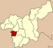
Amphoe Nong Saeng (Thai: อำเภอ หนองแซง) ist ein Landkreis (Amphoe - Verwaltungs-Distrikt) in der Provinz Saraburi. Die Provinz Saraburi liegt in der Zentralregion von Thailand.
Inhaltsverzeichnis
Geographie
Benachbarte Bezirke (von Norden im Uhrzeigersinn): Amphoe Sao Hai, Amphoe Mueang Saraburi und Amphoe Nong Khae der Provinz Saraburi sowie Amphoe Phachi und Amphoe Tha Ruea der Provinz Ayutthaya.
Geschichte
Nong Saeng war ursprünglich ein Unterbezirk (King Amphoe) des Amphoe Sao Hai. Er bekam jedoch den vollen Amphoe-Status im Jahr 1953.
Viele Einwohner von Nong Saeng sind von Vientiane eingewandert. Sie gründeten ihre neue Siedlung in der Nähe eines Sumpfgebiets (Thai: หนอง - Nong), in dem viele Saeng-Bäume wuchsen. Daher nannten sie ihr Dorf „Ban Nong Saeng“.
Verwaltung
Amphoe Nong Saeng ist in neun Kommunen (Tambon) eingeteilt, die weiterhin in 69 Dorfgemeinschaften (Muban) gegliedert sind.
Nong Saeng (Thai: เทศบาลตำบลหนองแซง) selbst hat einen Kleinstadt-Status (Thesaban Tambon), sie besteht aus Teilen der Tambon Nong Saeng, Nong Khwai So und Kai So.
Es gibt außerdem fünf Verwaltungs-Organisationen („Tambon Administrative Organizations“ - TAO, Thai: องค์การบริหารส่วนตำบล) im Landkreis.
1. Nong Saeng หนองแซง 2. Nong Khwai So หนองควายโซ 3. Nong Hua Pho หนองหัวโพ 4. Nong Sida หนองสีดา 5. Nong Kop หนองกบ 6. Kai Sao ไก่เส่า 7. Khok Sa-at โคกสะอาด 8. Muang Wan ม่วงหวาน 9. Khao Din เขาดิน Weblinks

Amphoe: Amphoe Mueang Saraburi | Kaeng Khoi | Nong Khae | Wihan Daeng | Nong Saeng | Ban Mo | Don Phut | Nong Don | Phra Phutthabat | Sao Hai | Muak Lek | Wang Muang | Chaloem Phra Kiat
Wikimedia Foundation.
Schlagen Sie auch in anderen Wörterbüchern nach:
Amphoe Nong Saeng, Saraburi Province — Infobox Amphoe thai=หนองแซง name=Nong Saeng province=Saraburi coordinates=coord|14|29|32|N|100|47|4|E|type:adm2nd region:TH area=87.081 population=14,781 population as of=2000 density=169.7 capital= location= postal code=18170 geocode=1905Nong… … Wikipedia
Amphoe Nong Saeng — There are two amphoe named Nong Saeng in Thailand, which, however, have two different Thai spellings Amphoe Nong Saeng, Saraburi Province (หนองแซง) Amphoe Nong Saeng, Udon Thani Province (หนองแสง) This disambiguation page lists articles about… … Wikipedia
Amphoe Nong Saeng — Es gibt in Thailand zwei Landkreise (Amphoe) mit dem Namen Nong Saeng. Sie können jedoch aufgrund ihrer thailändischen Schreibweise eindeutig zugeordnet werden: Amphoe Nong Saeng, Provinz Saraburi (หนองแซง) Amphoe Nong Saeng, Provinz Udon Thani… … Deutsch Wikipedia
Amphoe Nong Khae — Nong Khae หนองแค Provinz: Saraburi Fläche: 262,867 km² Einwohner: 88.213 (2005) Bev.dichte: 335,5 E./km² PLZ: 18140 … Deutsch Wikipedia
Nong Saeng District, Saraburi — Nong Saeng หนองแซง Amphoe Amphoe location in Saraburi Province … Wikipedia
Amphoe Nong Don — Nong Don หนองโดน Provinz: Saraburi Fläche: 88,07 km² Einwohner: 13.876 (2000) Bev.dichte: 157,5 E./km² PLZ: 18190 … Deutsch Wikipedia
Amphoe Nong Khae — Infobox Amphoe thai=หนองแค name=Nong Khae province=Saraburi coordinates=coord|14|20|21|N|100|51|42|E|type:adm2nd region:TH area=262.867 population=88,213 population as of=2000 density=335.5 capital= location= postal code=18140 geocode=1903Nong… … Wikipedia
Amphoe Mueang Saraburi — Mueang Saraburi เมืองสระบุรี Provinz: Saraburi Fläche: 301,6 km² Einwohner: 106.107 (2000) Bev.dichte: 351,8 E./km² PLZ … Deutsch Wikipedia
Amphoe Sao Hai — Sao Hai เสาไห้ Provinz: Saraburi Fläche: 111,8 km² Einwohner: 30.292 (2005) Bev.dichte: 270,9 E./km² PLZ: 18160 … Deutsch Wikipedia
Amphoe Tha Ruea — Tha Ruea ท่าเรือ Provinz: Ayutthaya Fläche: 106,2 km² Einwohner: 48.872 (2000) Bev.dichte: 460,2 E./km² PLZ: 13130 … Deutsch Wikipedia
Amphoe Nong Saeng (Saraburi)


18+
© Academic, 2000-2026
- Kontaktieren Sie uns: Unterstützung, Werbung
Wörterbücher Export, schritte mit PHP, Joomla, Drupal, WordPress, MODx.