Anamudi

Anamudi
Anamudi
Anaimudi.jpg
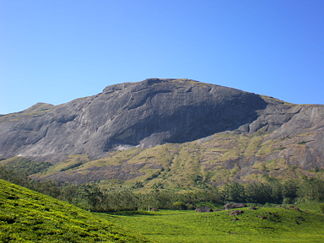
Höhe 2.695 m
Lage Kerala, Indien
Gebirge Westghats
Geographische Lage 10° 10′ 0″ N, 77° 4′ 0″ O10.16666666666777.0666666666672695Koordinaten: 10° 10′ 0″ N, 77° 4′ 0″ O
Anamudi (Kerala)
Anamudi

Anamudi oder Ana mudi (Malayalam ആനമുടി; tamilisch Anai mudi ஆனைமுட) ist der höchste Gipfel der Westghats im indischen Bundesstaat Kerala. Er liegt im Süden des Staates im Eravikulam-Nationalpark an der Verbindung der Cardamom Hills, Anaimalai Hills und der Palni Hills.

Mit einer Höhe von 2.695 m ist er der höchste Berg Südindiens.

Weblinks

 Commons: Anamudi – Sammlung von Bildern, Videos und Audiodateien

Wikimedia Foundation.

Игры ⚽ Поможем решить контрольную работу

Schlagen Sie auch in anderen Wörterbüchern nach:

  • Anamudi — Infobox Mountain Name = Anamudi Photo = Anaimudi.jpg Caption = Anamudi from Eravikulam National Park Elevation = convert|2695|m|ft|0 Location = Kerala, India Range = Western Ghats Prominence = convert|2479|m|ft|0 Coordinates =… …   Wikipedia

  • Anamudi Shola National Park — is a protected area located along the Western Ghats in Idukki District, Kerala state, South India. It is composed of Mannavan shola, Idivara shola and Pullardi shola, covering a total area of around 7.5 km². Draft notification of this new park… …   Wikipedia

  • Parque Nacional de Anamudi Shola — Saltar a navegación, búsqueda Parque Nacional de Anamudi Shola …   Wikipedia Español

  • Munnar — (മുന്നാര്‍ )   town   Munnar Hill station …   Wikipedia

  • Cardamom Hills — f1p5 Kardamomberge Die Kardamomberge (Cardamom Hills) auf der Karte des indischen Subkontinents. Höchster Gipfel Anamud …   Deutsch Wikipedia

  • Eravikulam National Park — Infobox Indian Jurisdiction native name= Eravikulam National Park other name = type= national park iucn category = II latd = 10.2|longd=77.083 locator position=left inset inset map size = 75px inset map x = 175px inset map y = 225px inset map… …   Wikipedia

  • Kardamomberge — f1p5 Kardamomberge Die Kardamomberge auf der Karte des indischen Subkontinents. Höchster Gipfel Anamudi ( …   Deutsch Wikipedia

  • Idukki district — Infobox Indian Jurisdiction type = district native name = Idukki hq = Painavu area total = 5105.22 area magnitude = 9 area total cite = latd = 9.85 longd = 76.94 locator position = left state name = Kerala altitude = 1200 abbreviation = IN KL IDU …   Wikipedia

  • Kerala — Malayalam is written in a non Latin script. Malayalam text used in this article is transliterated into the Latin script according to the ISO 15919 standard …   Wikipedia

  • Udumalaipettai — Infobox Indian Jurisdiction native name = Udumalpet| type = city | latd = 10.58| longd = 77.24 state name = Tamil Nadu district = Coimbatore leader title = leader name = altitude = population as of = 2001 population total = 59668| population… …   Wikipedia

Share the article and excerpts

Direct link
Do a right-click on the link above
and select “Copy Link”